The day after the selection of the teams for Paris-Nice 2018 on Monday 8 January, the Paris-Nice 2018 race route got announced. Unfortunately velowire.com has not been able to present you the race route of the 2018 edition of the Race to the sun at that time, but we catch up now with the usual presentation of the race route with detailed maps on Google Maps/Google Earth!
The 76th edition of Paris-Nice which starts this Sunday is made up of 8 stages (including 1 time trial) for a total distance of 1,198.9 km, visiting no less than 16 French departments and containing 27 climbs.
Let's now have a detailed look at the 8 stages of this Paris-Nice:
CONTINUE READING AFTER THIS ADVERTISEMENT
1/ Sunday 4 March 2018 - Chatou > Meudon - 135 km
As usual now since 2010, Paris-Nice 2018 starts in the Yvelines department, and more precisely in Chatou. In the neighbour department of the Hauts-de-Seine, at only about fifteen kilometers from there, the finish will be in Meudon, but the total distance of this stage will be 135 kilometers, following a race route which mainly stays in the Yvelines department.In Meudon, the finish could - contrary to what we're used to in Paris-Nice - this time not take place as a bunch sprint because the white line will be drawn after a severe climb (...), in front of the "Observatoire".
In addition to this final way up to the finish, the riders will have to climb the Côte des 17 tournants, well known to Parisian amateur cyclists, and the Côte de Méridon, both 3rd category climbs. They'll also find two intermediate sprints on their route, in Les Mesnuls and in Châteaufort.
Hereunder you'll find the time- and route schedule, the profile and the race route on Google Maps for the 1st stage of Paris-Nice 2018. Click on the images to open them.


2/ Monday 5 March 2018 - Orsonville > Vierzon - 187.5 km
Back in the Yvelines department at the start of the second stage which will be a bit longer, with its 187.5 kilometers between Orsonville and Vierzon (Cher departement).During this stage the peloton will cross the Loiret department where they'll find the intermediate sprint in Patay and the feeding zone in Huisseau-sur-Mauves.
Just after the second intermediate sprint in Saint-Georges-sur-la-Prée, the finish in Vierzon will be in the Avenue du 14 Juillet, slightly uphill, or -as the mayor of Vierzon, Nicolas Sansu, said in Le Berry Républicain - "a short ramp for the professional riders but an important climb for the Sunday amateur riders", adding to that that this will be "a beautiful finish, very large, with 800 meters straight: 400 meters flat and 400 meters climbing".
Hereunder you'll find the time- and route schedule, the profile and the race route on Google Maps for the 2nd stage of Paris-Nice 2018. Click on the images to open them.


3/ Tuesday 6 March 2018 - Bourges > Châtel-Guyon - 210 km
The longest stage of this Paris-Nice 2018 will take place between Bourges in the Cher department and Châtel-Guyon in the Puy-de-Dôme, with a local circuit around the finish city to end with.In the first half of the stage the riders will battle for the intermediate sprint in Le Brethon and get some additional energy in the feeding zone in Verneix. In the second half, they'll climb two 3rd category climbs before they get on the local circuit around the finish city, the Côte de la Bosse and the Côte des Boulards. After a first crossing of the finish line in the Avenue de l'Europe in Châtel-Guyon they'll get on the last climb of the day, the Côte de Charbonnières (3rd category).
Hereunder you'll find the time- and route schedule, the profile and the race route on Google Maps for the 3rd stage of Paris-Nice 2018. Click on the images to open them.


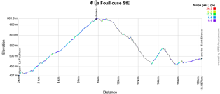
4/ Wednesday 7 March 2018 - La Fouillouse > Saint-Etienne - individual time trial - 18.4 km
Halfway the week, there'll be an individual effort during the time trial of a bit under twenty kilometers between La Fouillouse and Saint-Etienne on a race route which is slightly uphill in the first 8 kilometers, as you can see in the stage profile below.Hereunder you'll find the time- and route schedule, the profile and the race route on Google Maps for the 4th stage of Paris-Nice 2018. Click on the images to open them.


CONTINUE READING AFTER THIS ADVERTISEMENT
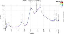
5/ Thursday 8 March 2018 - Salon-de-Provence > Sisteron - 165 km
After a transfer towards the south, the riders of Paris-Nice 2018 will get back together at the start in Salon-de-Provence for the 5th stage of the race, which will go up north ... this will be pretty much a transition stage but one or more strong riders could decide to get off in a breakaway towards the fortifications of Sisteron.They'll have quite some playfield for that, with the Col de Pointu (2nd category) in the first half of the stage and the Col de Lagarde-d'Apt of the 1st category and, after the intermediate sprint and the feeding zone in Revest-du-Bion, two 3rd category climbs: the Col du Négron and, on the circuit around the finish, the Côte de la Marquise. Going back towards the point where the riders got on the local circuit they'll find an intermediate sprint in Sisteron before going up north again towards the finish line in the same city.
Hereunder you'll find the time- and route schedule, the profile and the race route on Google Maps for the 5th stage of Paris-Nice 2018. Click on the images to open them.


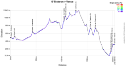
6/ Friday 9 March 2018 - Sisteron > Vence - 198 km
Sisteron will also be the start location of the 6th stage of Paris-Nice 2018. That's where the mountaineous triptych which forms the final part of the 76th edition of Paris-Nice will start, via Vence, the finish of this stage, La Colmiane the next day and finally Nice. These three days will offer a maximum of possibilities for attacking riders.This Friday, after the intermediate sprint early in the stage in Préfaissal, the road will slowly go up towards the foot of the first climb, the Col de Luens (6,9 km à 4,7%, 2nd category) where the riders will find the intermediate sprint in La Garde, and rapidly afterwards they'll go on with another climb, the Col Bas (1,7 km à 7,2%, 2nd category). After an easier part, two other climbs of the 2nd category will be awaiting the riders, the Côte de Cipières (2,8 km à 5,6%) and the Côte de Gourdon (3,8 km à 4,2%).
After a long descent, there will still be the steep Côte de la Colle-sur-Loup (1st category, 1,8 km à 10%) which awaits the riders and via the intermediate sprint in Saint-Paul-de-Vence they'll climb towards the finish in Vence where the gaps for the general classification might thus be high due to the climbs all along this stage!
Hereunder you'll find the time- and route schedule, the profile and the race route on Google Maps for the 6th stage of Paris-Nice 2018. Click on the images to open them.


7/ Saturday 10 March 2018 - Nice > Valdeblore La Colmiane - 175 km
On Saturday 10 March 2018 the second part of the mountaineous tryptich of Paris-Nice 2018 will start in Nice. Quite quickly after the km 0, the riders will have to climb the Côte de Gattières (2nd category), followed by the intermediate sprint of Le Broc. Getting further in the backland of Nice, 3 climbs will follow up on each other, starting with the Côte de la Sainte-Baume of the 1st category (16,7 km à 3,8%) and, after the feeding zone in La Penne, the Col de Saint-Raphaël (2nd category, 5,8 km à 4,2%) and the Côte de Villars-sur-Var (2nd category, 2,1 km à 6,7%). The intermediate sprint of Tournefort might be disputed by breakaway riders due to these preceding climbs. Will they manage to keep ahead in the final climb towards La Colmiane in Valdeblore? Or will this climb be decisive and maybe even lead to a change of the rider who wears the yellow jersey with the white band as the leader of the general classification?Hereunder you'll find the time- and route schedule, the profile and the race route on Google Maps for the 7th stage of Paris-Nice 2018. Click on the images to open them.


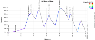
8/ dimanche 11 March 2018 - Nice > Nice - 110 km
The very last stage of Paris-Nice 2018 will be short, with only 110 kilometers, but not without difficulties, starting and finishing in Nice. Indeed, there will be no less than 6 climbs on the programme of these 110 kilometers! The first one will be the Côte de Levens (2nd category, 6,2 km à 5,6%). After the sprint in Levens, they'll continue towards the Côte de Châteauneuf (2nd category, 5,3 km à 4,3%), the Col de Calaïson (2nd category, 6,3 km à 4,5%) and the Côte de Peille (1st category, 6,6 km à 6,8%).Once they get closer to the coast, the riders will find the last intermediate sprint of Paris-Nice 2018 in La Turbie before they'll continue on the climb of the Col d'Eze (1st category, 1,6 km à 8,1%) and the circuit around the "Observatoire de la Côte d'Azur" which ends in the climb of the Col des Quatre Chemins (2nd category, 5,5 km à 5,5%). And that's where they'll go on towards Nice where the race will end -as usual- on the Promenade des Anglais!
Hereunder you'll find the time- and route schedule, the profile and the race route on Google Maps for the 8th stage of Paris-Nice 2018. Click on the images to open them.


CONTINUE READING AFTER THIS ADVERTISEMENT
The Paris-Nice 2018 race route in Google Earth
Hereabove you have discovered the race route of the stages of Paris-Nice 2018 on Google Maps, as well as the stage profiles and their time- and route schedules. If you'd like to see the complete Paris-Nice 2018 race route in a single view or if you'd like to do a virtual fly-over of one or more of these stages for example, you can find a link below which allows you to download the Paris-Nice 2018 race route in Google Earth, thanks to its KML file:>> Download the Paris-Nice 2018 race route in Google Earth

Vond u dit artikel interessant? Laat het uw vrienden op Facebook weten door op de buttons hieronder te klikken!
3 comments | 6961 views
this publication is published in: Paris-Nice | Paris-Nice 2018


 by Thomas Vergouwen over
Très beau et bon travail comme à chaque fois (je n'arrete pas de le répéter ici :) )
Cependant, je note une erreur sur l'arrivée d'aujourd'hui et notamment sur la dernière côte de la Colle sur Loup .
Le tracé passe en effet par le Boulevard Honoré Teisseire,Rue Clara Gasquet, Chemin du Brusquet, Rue Pierre Raybaud, Chemin de la Puade, Chemin de l’Avencq, Avenue des Jardins de France, Avenue de La Colle.
Plus de renseignements "lacollesurloup.fr/fr/actualites/course-cycliste-parisnice"
Cdt
Merci pour cette précision Nico ! :)
C'est le souci d'un livre de route, il faut tenter de deviner le passage en ville / village sur la base de l'itinéraire horaire et la carte. Je me rends compte que sur ce passage précis je n'ai pas assez bien vérifié la carte car effectivement, j'aurais vu que le passage tracé ci-dessus n'est pas tout à fait juste :-(. Désolé !
Merci pour le travail