This Sunday, the 67th edition of the Critérium du Dauphiné will start in Ugine (Savoie) for a mountaineous ride of 1,212.5 kilometers.
Some sort of a mini Tour de France, as a preparation on the Grande Boucle which will start in Utrecht in less than 30 days! A few elements of the Tour will be present in this Critérium du Dauphiné 2015 including mainly the climb of the already famous Lacets de Montvernier and the stage Digne-les-Bains > Pra Loup!
In this article you'll discover all the details of the race route of this Dauphiné, including the time- and route schedules, the stage profiles and the race route on Google Maps/Google Earth, which will give you all the information to know where the race will come by.
The Critérium du Dauphiné 2015 race route on Google Maps, the time- and route schedules and the stage profiles
The Critérium du Dauphiné 2015 race route is made up of 7 stages in line and one team time trial. Taking place on Tuesday, this time trial could allow a team to take over the general classification but if that's the case, that'll only be temporary because there will still be 5 other difficult stages which will allow the climbers to gain some time.CONTINUE READING AFTER THIS ADVERTISEMENT
1/ Sunday 7 June 2015 - Ugine > Albertville - 131.5 km
The first stage of the Critérium du Dauphiné 2015 will start in the small town Ugine in the Savoie department and the stage will be short with only 131.5 kilometers.The stage will have a particular form because it's only 7 kilometers after the km 0 that the riders will already get to the finish city, Albertville. That's however only where the stage really starts because, after a short visit south-east of Albertville - via Tours-en-Savoie, Saint-Paul-sur-Isère, La Bâthie and back to Tours-en-Savoie and Albertville, which includes the climb of the Côte d'Esserts-Blay -, the riders will get on a circuit west of the finish city. They first do one lap on a circuit of 19.5 kilometers (in purple on the map), with the Côte du Villard and the Côte du Cruet and than 5 laps on a similar circuit (16 km; in yellow on the map) which however cuts off before the Côte du Cruet and thus only contains the Côte du Villard which the riders will thus climb 6 times.
Hereunder you'll find the time- and route schedule, the stage profile and the race route on Google Maps for this stage. Click on the images to open them.


2/ Monday 8 June 2015 - Le Bourget-du-Lac > Parc des Oiseaux - Villars-les-Dombes - 173 km
The second stage will start in Le Bourget-du-Lac, on the side of the lake, and the riders will immediately start the climb of the Col du Chat (2nd category). About sixty kilometers further, the riders will climb the Col de Cuvéry (1st category), on top of which they'll also find the feeding zone.They'll be about halfway to their destination of the day, the Parc des Oiseaux in Villars-les-Dombes which saw a visit of the Critérium du Dauphiné for the last time in 2013, with an individual time trial (see the photos).
Hereunder you'll find the time- and route schedule, the stage profile and the race route on Google Maps for this stage. Click on the images to open them.


3/ Tuesday 9 June 2015 - Roanne > Montagny - team time trial - 24.5 km
After these two stages in line, there will be a timed effort. And this time it will not be an individual time trial like in 2013 at the Parc des Oiseaux, no, it'll be a team time trial between Roanne and Montagny over a distance of 24.5 kilometers.Without any big difficulties, the race route does however contain a small climb, followed by a progressive climb towards the finish.
Hereunder you'll find the time- and route schedule, the stage profile and the race route on Google Maps for this stage. Click on the images to open them.


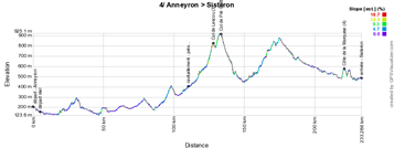
4/ Wednesday 10 June 2015 - Anneyron - Porte de DrômArdèche > Sisteron - 228 km
A bit more south-east, the riders will start in Anneyron the next day, for a stage of 228 kilometers of which the first half is just a bit hilly, followed by a bit more mountaneous second half. After the feeding zone close to Mornans, the riders will climb the Col de Lescou (3rd category) and the Col de Pré Guittard (4th category) followed by a non referenced climb close to Ribeyret before they continue downhill towards the finish in Sisteron.Hereunder you'll find the time- and route schedule, the stage profile and the race route on Google Maps for this stage. Click on the images to open them.


CONTINUE READING AFTER THIS ADVERTISEMENT
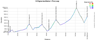
5/ Thursday 11 June 2015 - Digne-les-Bains > Pra Loup - 161 km
Between Digne-les-Bains and Pra Loup it'll be a real mountaneous stage on this Thursday 11 June and this same stage will be the 17th stage of the Tour de France 2015.After about fourty kilometers, the riders get on top of the first difficulty of the day, the Col des Léques (3rd category) and about 25 kilometers further they'll have already climbed the Col des Toutes Aures (3rd category).
After the feeding zone in Annot, things start to get serious with the climb of the Col de la Colle Saint-Michel of the 2nd category and, close to the finish, the climb of the Col d'Allos (1st category, 14 km at 5.5%). After the descent of this last climb, they'll still have to do the final climb towards the finish at Pra Loup.
Hereunder you'll find the time- and route schedule, the stage profile and the race route on Google Maps for this stage. Click on the images to open them.


6/ Friday 12 June 2015 - Saint-Bonnet-en-Champsaur > Villard-de-Lans - Vercors - 183 km
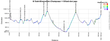
After a transfer north of Gap, the riders will start the 6th stage this Friday 12 June in Saint-Bonnet-en-Champsaur for 183 kilometers of racing full of small climbs.After a bit less than 20 kilometers, they'll be at the foot of the Rampe de Motty which is a steep climb with its 8.3% over 2.3 kilometers (3rd category). They'll than continue on the Côte du Barrage du Sautet (3rd category) before a slightly hilly part until the foot of the Col de la Croix Haute (2nd category). This climb goes on in the climb of the Col de Grimone (3rd category) which will be followed by a long descent towards the feeding zone in Die.
Just after the feeding zone they'll start a 13.8 kilometers long climb with an average steepness of 5.4% towards the top of the Col du Rousset (1st category) and after a hilly part, the riders will end with a short climb towards the finish in Villard-de-Lans.
Hereunder you'll find the time- and route schedule, the stage profile and the race route on Google Maps for this stage. Click on the images to open them.


7/ Saturday 13 June 2015 - Montmélian > Saint-Gervais Mont Blanc - 155 km
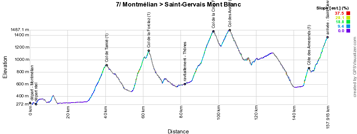
The forelast stage of the Critérium du Dauphiné 2015 will start a bit more north-east, in Montmélian, south of Chambéry.This will be a real mountain stage with its 4 first category climbs, one 3rd category climb and the final first category climb. The climbs the riders will do successively are the Col de Tamié (1st category, 8.5 km at 6.4%), the Col de la Forclaz (1st category, 8.1 km at 7.8%), the Col de la Croix Fry (1st category, 11.3 km at 7%), the Col des Aravis (3rd category, 4.3 km at 5.8%), the Côte des Amerands (1st category, 2.7 km at 11,2%) and the final climb towards Saint-Gervais Mont Blanc of the 1st category (a climb of 7 km at 7.7%).
Hereunder you'll find the time- and route schedule, the stage profile and the race route on Google Maps for this stage. Click on the images to open them.


8/ Sunday 14 June 2015 - Saint-Gervais Mont Blanc > Modane Valfréjus - 156,5 km
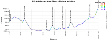
The last stage is a bit easier after the start in Saint-Gervais Mont Blanc, with the Côte d'Héry-sur-Ugine (2nd category) followed by a descent and the Côte d'Aiton (4th category), Côte de Saint-Georges-d'Hurtières (3rd category), the feeding zone in Saint-Rémy-de-Maurienne and the Lacets de Montvernier (2nd category) which will also be part of the Tour de France 2015 and which will give some superb images facing the mountain.Close to the finish the riders climb the Côte de Saint-André (3rd category) followed by the final climb towards Modane Valfréjus (1st category, a climb of 8.4 km at 5.7%). That's where we'll know the name of the rider who will follow up on Andrew Talansky as the winner of the Critérium du Dauphiné.
Hereunder you'll find the time- and route schedule, the stage profile and the race route on Google Maps for this stage. Click on the images to open them.


The Critérium du Dauphiné 2015 race route in Google Earth
Do you prefer to see the full race route of the Critérium du Dauphiné 2015 in Google Earth, simply to have an overall look of it or because you want to do a virtual fly-over of one or more of the stages? That's possible by downloading the following KML file! ATTENTION - copyright: despite the fact that this KML is made available for your own use, you must keep in mind that it's stricly forbidden to reproduce the contents of this KML file or of any other file (including the maps, the profiles, the KML files and others) which make up the race route of the Critérium du Dauphiné 2015. These contents - as any other contents on velowire.com and more generally on the internet - are protected by copyright and I thus ask you to pay some respect for the important amount of time spent on the creation of them. This protection thus concerns the reproduction of the maps or any other elements in no matter which form (as a map, a fly-over video of the maps or any other creation based on the contents published on velowire.com).
>> Download the full race route of the Critérium du Dauphiné 2015 in Google Earth (KML file, 595 kB)

Vond u dit artikel interessant? Laat het uw vrienden op Facebook weten door op de buttons hieronder te klikken!
no comments yet | 21622 views
this publication is published in: Criterium du Dauphiné | Critérium du Dauphiné 2015 | OpenStreetMap/Google Maps/Google Earth


 by Thomas Vergouwen over