


As usual, velowire.com allows you to discover all details of the race route of this 101ème edition of the Grande Boucle, on Google Maps/Google Earth, and this time this exclusive content is already available at about two weeks from the start of the Tour de France 2014.
With the information in this article you'll get to know all details, all cities and all villages which will be visited by the Tour and it will thus allow you to prepare your visit if you go watch the race live or to simply better understand the race!
Some preliminary information ...
Some of you might have already discovered the race route on Google Maps as published by the organisor of the Tour de France on this official website of the race.velowire.com could thus have simply forwarded you to that website or integrate the maps as published on letour.fr. When you look a little closer however, you quickly discover that these maps are not as detailed as those you usually find on velowire.com (the tracks don't really correctly follow the roads) and there are also several errors in the track which are quite visible if you zoom enough. Furthermore, on letour.fr you would not have been able to watch the race route in Google Earth and thus for example do a virtual fly-over of the stages of the Tour de France 2014.
That's why you'll find in this article, as usual for many cycling races, all information about the race route of the 101st Tour, with the race route on Google Maps, the itineraries and the stage profiles, as well as detailed information about the cities the race visits, the departments (French administrative areas) it goes through, the climbs, the sprints, the feeding zones, the roads the riders will follow between the fictive start and km 0 of each of the stages and some other information which might be useful to better understand the race route of this Tour de France with a British-Belgian-French accent!
Two further important bits of information before you get to discover the details of all stages of the Tour de France 2014:
- as for any contents on velowire.com, its reproduction is strictly forbidden, whether that's in original or modified form, as indicated on the copyright page. Please show your respect for the time spent on the preparation of exclusive contents like these!
- the stage profiles have been generated automatically based on altitude informations known for the places the race visits; it could thus be a bit unprecise at some places but in general the profile is right!
The programme of the Grand Départ of the Tour de France 2014
Here are the main dates to keep in mind for the Grand Départ of the Tour de France 2014:- Wednesday 2 July 2014 : opening of the permanence and the press room in Wellington Place in Leeds
- Thursday 3 July 2014 : teams presentation in the Leeds Arena
- Saturday 5 July 2014 : first stage of the Tour de France 2014 between Leeds and Harrogate, over 190.5 km
- Sunday 6 July 2014 : second stage of the Tour de France 2014 between York and Sheffield, over 201 km
- Monday 7 July 2014 : third stage of the Tour de France 2014 between Cambridge and London, over 155 km
The race route of the Tour de France 2014 on Google Maps
Let's now discover all the details of the Tour de France 2014 race route, stage by stage:CONTINUE READING AFTER THIS ADVERTISEMENT
1/ Saturday 5 July 2014 - Leeds (UK) > Harrogate - 190.5 km
One of the specialists of the sprint could well be the first to wear the yellow jersey after the first stage in Harrogate since this stage will end in a long straight line in the city center of Yorkshire. Before they get there, the riders will start in Leeds at the foot of the Leeds Art Gallery and the Town Hall. They'll first go off north up to Harewood where they'll leave the main road to come by Harewood House (photo Elliott Brown), a magnificent and monumental domain which is part of the Treasure Houses of England. In front of this domain the official start ceremony of the Tour de France 2014 will take place.
They'll then continue west up to Skipton and then turn north again to go visit the Yorkshire Dales National Park where the race route becomes hilly, with the climb of the Côte de Cray (4 ; ^ 416 m / 1.6 km @ 7.1 %), the Côte de Buttertubs (3 ; ^ 532 m / 4.5 km @ 6.8 %) and the Côte de Griton Moor (3 ; ^ 383 m / 3 km @ 6.6 %). Between the two first climbs, the riders will battle for the first intermediate sprint of this 101st Grande Boucle in Newbiggin. Once they leave this park, the race route will turn south-east via Leyburn and Ripon and then off to the finish line in Harrogate more south.
Since the final part of the stage is again flat and the last straight line is very long towards the white line drawn in the center of Harrogate, it is most probable that this stage ends in a sprint! While the organisor indicated for the Tour de France 2013 that a sprinter could take the first yellow jersey for the first time since 1967 and the creation of the prologue (see the article Tour de France 2013: the Hundredth, a legendary Tour? for more information), this could thus again be the case in 2014.
Hereunder you'll find the itinerary, the profile and the race route on Google Maps for this stage. Click on the images to open them.


 start : after the rendez-vous in front of the Leeds Art Gallery on The Headrow, the riders will follow the roads in Leeds from 11.10AM over 14.6 km towards Harewood and more precisely Harewood House for the official start ceremony while this historical site will be alors que the site historique sera survolé par les Royal Air Force Red Arrows (photo Airwolfhound. A little bit over 2 kilometers further, the km 0 of this first stage of the Tour de France 2014 will be at noon
- climbs : 3 climbs are on the programme of this first stage, the Côte de Cray of the 4th category (^ 416 m / 1.6 km @ 7.1 %), the Côte de Buttertubs of the 3rd category (^ 532 m / 4.5 km @ 6.8 %) and the Côte de Griton Moor of the 3rd category (^ 383 m / 3 km @ 6.6 %)
- feeding zone : Aysgarth
- intermediate sprint : Newbiggin at km 77, sur la B6160
- finish : W Park in Harrogate
- visited departments : West Yorkshire from km 0 till km 24, North Yorkshire from km 24 till km 190.5
- main cities : Leeds, Skipton, (Yorkshire Dales National Park), Leyburn, Ripon, Harrogate
 start : after the rendez-vous in front of the Leeds Art Gallery on The Headrow, the riders will follow the roads in Leeds from 11.10AM over 14.6 km towards Harewood and more precisely Harewood House for the official start ceremony while this historical site will be alors que the site historique sera survolé par les Royal Air Force Red Arrows (photo Airwolfhound. A little bit over 2 kilometers further, the km 0 of this first stage of the Tour de France 2014 will be at noon
Now discover exclusively on velowire.com the race route of this 1st stage of the Tour de France 2014 in a virtual fly-over in the video below:
2/ Sunday 6 July 2014 - York > Sheffield - 201 km
 The second stage of the Tour de France 2014 will start in York, still in Yorkshire and turn around Leeds towards Sheffield. This stage contains, mainly in its second half, many hills: there are no less than 9 referenced for the King of the Mountains classification.
After having visited the city of York, the riders will go off west, again visit Harrogate (the finish city of the previous stage), down to Beamsley. They'll then turn south, via Keighley, Haworth and Hebden Bridge. A short visit east will bring them to Huddersfield before they again go south towards Woodhead where they enter - in eastern direction - the Peak District National Park where the riders will find even more climbs than in the first 140 kilometers of the stage.
The last climb will be at about 5 kilometers from the finish, the Côte de Jenkin Road in Wincobank, before the finish in Sheffield, not far from the Don Valley Stadium.
Hereunder you'll find the itinerary, the profile and the race route on Google Maps for this stage. Click on the images to open them.


- start : after the rendez-vous at the York Racecourse, the fictive start will be at 11AM and the riders will follow the streets of York, passing in front of Clifford's Tower, Mansion House and the York Minster cathedral (photo above chippykev), towards the A59 where the km 0 will be reached at 11.20AM at 8.1 km of the meeting place
- climbs : Côte de Blubberhouses of the 4th category (^ 301 m / 1.8 km @ 6.1 %), Côte d'Oxenhope Moor of the 3rd category (^ 431 m / 3.1 km @ 6.4 %), Côte de Ripponden of the 3rd category (^ 252 m / 1.3 km @ 8,6 %), Côte de Greetland of the 3rd category (^ 200 m / 1,6 km @ 6,7 %), Côte de Holme Moss of the 2nd category (^ 521 m / 4,7 km @ 7 %), Côte de Midhopestones of the 3rd category (^ 341 m / 2.5 km @ 6.1 %), Côte de Bradfield of the 4th category (^ 350 m / 1 km @ 7.4 %), Côte d'Oughtibridge of the 3rd category (^ 241 m / 1.5 km @ 9.1 %) and finally the Côte de Jenkin Road of the 4th category (^ 132 m / 800 m @ 10.8 %)
- feeding zone : Hebden Bridge
- intermediate sprint : on the A629 at the entrance of Keighley at km 68.5
- finish : Attercliffe Common in Sheffield
- visited departments : North Yorkshire from km 0 till km 54.5, West Yorkshire from km 54.5 till km 143.5, Derbyshire from km 143.5 till km 148 and South Yorkshire from km 148 till km 201
- main cities : York, Harrogate, Keighly, Huddersfield, Sheffield
3/ Monday 7 July 2014 - Cambridge > London - 155 km
The riders will go off south-east down to Chelmsford and then south-west via the sprint in Epping and then entering the capital via the Olympic Park of the 2012 Olympic Games, followed by an entranced in the city center from the east side, which allows to rediscover the TV images of the Tower Bridge, of the Big Ben (photo, © Thomas Vergouwen/velowire.com), of the Palace and the Abbey of Westminster before a finish on The Mall in London, in front of Buckingham Palace where we also saw the finish of the prologue of the Tour de France 2007 and of the road race of the Olympic Games.
Hereunder you'll find the itinerary, the profile and the race route on Google Maps for this stage. Click on the images to open them.


- start : after the rendez-vous on Gonville Place, the fictive start will be at 12.15PM and the riders will follow Regent Street, St Andrew's Street, Sidney Street, Bridge Street, Trinity Street, King's Parade, Trumpington Road/A1134, High Street/A1309 where the km 0 will be reached at 12.25PM at 4.9 km of the meeting place
- climbs : no difficulties
- feeding zone : Chelmsford
- intermediate sprint : Epping Forest at km 108
- finish : The Mall in London
- visited departments : Cambridgeshire from km 0 till km 5.5, Essex from km 5.5 till km 118, Greater London from km 118 till km 155
- main cities : Cambridge, Saffron Walden, Finchingfield, (close to Braintree), Chelmsford, London
4/ Tuesday 8 July 2014 - Le Touquet-Paris-Plage > Villeneuve-d'Ascq / Lille Métropole - 163.5 km
 The 4th stage of the Tour de France is the first in France and will start in Le Touquet-Paris-Plage where the riders will arrive after the previous stage by plane.
They'll briefly go south-east but then continue north-east towards Belgium and Steenvoorde where they'll turn right following the border. After having crossed Lille, this stage will end in a sprint at the foot of the Pierre Mauroy stadium in Villeneuve-d'Ascq.
Hereunder you'll find the itinerary, the profile and the race route on Google Maps for this stage. Click on the images to open them.


- start : the riders will start on the Boulevard de la Plage at 1.35PM and then follow the Rue Jean Monnet, Boulevard Daloz, Avenue Saint Jean / Avenue du Verger / Place de l'Hermitage, Avenue du Général de Gaulle (D939), Avenue des Anglais, Avenue François Godin (D144), Avenue de la Libération (D940) in Cucq, Avenue de la Côte Opale (D144) and finally the Route d'Etaples in Villiers where the km 0 will be reached at 1.55PM at 10 kilometers of the meeting place
- climbs : two difficulties of the 4th category are part of the King of the Mountains classification of the Tour de France 2014 in this 4th stage, the Côte de Campagnette at km 34 (^ 159 m / 1 km @ 6.5 %) and the Mont Noir at km 117.5 (^ 147 m / 1.3 km @ 5.7 %)
- feeding zone : Renescure
- intermediate sprint : in the Rue Bollaert le Gavrian in Cassel
- finish : in the Boulevard de Tournai, at the Stade Pierre Mauroy, in Villeneuve-d'Ascq
- visited departments : Pas-de-Calais (62) from km 0 till km 78,5, Nord (59) from km 78.5 till km 108 and from km 108.5 till km 163.5, short visit of the Province de Flandre Occidentale in Belgium over 500 meters at km 108
- main cities : Le Touquet-Paris-Plage, Montreuil, Hucqueliers, Lumbes, Saint-Omer, Cassel, Steenvoorde, Armentières (photo of the town hall, lilas59), Lille, Villeneuve-d'Ascq
CONTINUE READING AFTER THIS ADVERTISEMENT
5/ Wednesday 9 July 2014 - Ypres (BE) > Arenberg Porte du Hainaut - 155.5 km
After a brief part north, the riders will cross the border with France after 54 kilometers, towards Roubaix, followed by a visit (in opposite order) of the famous cobble stones of Paris-Roubaix. Indeeed, 15.4 kilometers of cobble stones are on the programme, spread out over 9 sections of which the longest is 3.7 km. The last section is at only 5 kilometers from the finish in Arenberg Porte du Hainaut where Thor Hushovd won the stage in 2010 (here on my photo in [[Paris-Roubaix 2014]], © Thomas Vergouwen/velowire.com). The impact that this stage will have on the general classification of the Tour de France 2014 remains completely uncertain until 9 July, but one thing is sure: Hushovd will not win this stage in 2014 since the Norwegian rider will not come to the start of the race!
Hereunder you'll find the itinerary, the profile and the race route on Google Maps for this stage. Click on the images to open them.


- start : the fictive start will be in the Rijsselstraat (Rue de Lille) in Ypres (in Belgium) at 1.45PM and the riders will follow the Zuiderring, the Zillebekevoetweg / Steverlyncklaan, Meenseweg, the Kruiskalsijdestraat and the Zonnebeekseweg where the km 0 will be reached at 2PM at 6.4 km from the meeting place
- cobble stones sections : from Gruson to the Carrefour de l'Arbre at km 87 (1,100 meters, from Ennevelin to Pont-Thibault at km 103.5 (1,400 meters), Mons-en-Pévèle at km 110 (1,000 meters), Bersée at km 114.5 (1,400 meters), from Orchies to Beuvry-la-Forêt at km 125.5 (1,400 meters), from Sars-et-Rosières to Tilloy-les-Marchiennes at km 131 (2,400 meters), from Brillon to Warlaing at km 135 (1,400 meters), from Wandignies-Hamage to Hornaing at km 140 (3,700 meters) and from Hélesmes to Wallers at km 149 (1,600 meters)
- feeding zone : Pont-à-Marcq
- intermediate sprint : Rue de l'Hardinière in Templeuve at km 97
- finish : avenue Michel Rondet in Arenberg Porte du Hainaut
- visited departments : Province de Flandre-Occidentale in Belgium from km 0 till km 54, Province de Hainaut in Belgium at km 54, Nord (59) from km 58 till km 155.5
- main cities : Ypres (BE), Roeselare (BE), Roubaix, Villeneuve-d'Ascq, Arenberg
6/ Thursday 10 July 2014 - Arras > Reims - 194 km
 During the 6th stage between Arras and Reims, the Tour de France continues its remembrance of the 100 years of the start of the first World War, visiting the battle fields of the Somme and most importantly in Péronne which the Germans occupied briefly in 1914 and longer in 1916/1917 and again in 1918.
The riders will also follow the Chemin des Dames (the Track of the Ladies, photo tofedupin) which got this name due to the fact that it was taken by the daughters of the King Louis XV, the Dames de France, to go to the Château de La Bove in the Aisne department from Paris, but which became famous in history after having been the place of big battles during the first World War (and also the second).
From a sports perspective, Thierry Gouvenou sees in this stage a stage for courageous riders with a breakaway which could resist until the finish, especially due to the numerous turns in the final in which the wind could play an important role. However, if no riders get away or if the breakaway is taken back, the stage will of course finish in Reims in a classical sprint, like in 2010 when Alessandro Petacchi won the stage.
Hereunder you'll find the itinerary, the profile and the race route on Google Maps for this stage. Click on the images to open them.


- start : the fictive start will be at 12.50PM in front of the Citadelle d'Arras and once they passed under the gat, the riders will follow the Boulevards du Général Leclerc, Vauban and Carnot, the Avenues du Maréchal Leclerc and Fernand Lobbedez, the Route de Bapaume, the Rue de la République, the Rue Pierre Curie / D917 where the km 0 will be reached at 1.00PM at 5.5 km from the meeting place
- climbs : two difficulties are on the programme, the Côte de Coucy-le-Château-Auffrique of the 4th category at km 107.5 (^ 113 m / 900 m @ 6.2 %) and the Côte de Roucy also of the 4th category at km 157 (^ 194 m / 1.5 km @ 6.2 %)
- feeding zone : Viry-Noureuil
- intermediate sprint : Rue du 52ème Régiment d'Infanterie in Pinon at km 119
- finish : Boulevard Victor Hugo in Reims
- visited departments : Pas-de-Calais (62) from km 0 till km 22.5, Somme (80) from km 22.5 till km 62.5, Aisne (02) from km 62.5 till km 157, Marne (51) from km 157 till km 194
- main cities : Arras, Bapaume, Péronne, Tergnier, Chauny, Reims
7/ Friday 11 July 2014 - Epernay > Nancy - 234.5 km
 One of the longer stages of the Tour de France 2014 will take this Friday 11 July. The riders will start in Epernay for a stage without any big difficulties (photo: a route close to Epernay in the middle of the wineyards, together with the previous stage, this stage is one of the rare stages where we'll see the champagne before the prize ceremony! ; photo Vincent Brassinne).
After a first easy part of the stage going east towards Verdun and the intermediate sprint of Hannonville-sous-les-Côtes, the riders will get via Toul on two climbs which will form the final part of this stage and with the top of the Côte de Boufflers at only 5.5 kilometers from the finish, this configuration could well prevent the sprinters to take the stage victory.
Hereunder you'll find the itinerary, the profile and the race route on Google Maps for this stage. Click on the images to open them.


- start : the fictive start of this stage will be at 11.35AM in the Rue Général Leclerc in Epernay and the riders will follow the Rue Saint-Martin and then the Boulevard de la Motte before they get back close to the meeting place via the Place Pierre Mendès France / Rue Jean Moët and then left on the Avenue de Champagne, Rue de Lorraine, Rue Charles Gounod, Avenue Beethoven, Rue Emmanuel Chabrier and again the Avenue de Champagne / D3 where the km 0 will be reached at 11.55AM at 9 km from the meeting place
- climbs : Côte de Maron of the 4th category at km 217.5 (^ 398 m / 3.2 km @ 5 %) and Côte de Boufflers also of the 4th category at km 229 (^ 333 m / 1.3 km @ 7.9 %)
- feeding zone : Charny-sur-Meuse
- intermediate sprint : Route de Thillot in Hannonville-sous-les-Côtes at km 148
- finish : Cours Léopold in Nancy
- visited departments : Marne (51) from km 0 till km 76.5, Meuse (55) from km 77 till km 163.5, Meurthe-et-Moselle (54) from km 163.5 till km 234.5
- main cities : Epernay, Châlons-en-Champagne, Sainte-Ménehould, Verdun (close) and its Mémorial de Verdun 1914-1918, Toul and Nancy
8/ Saturday 12 July 2014 - Tomblaine > Gérardmer (La Mauselaine) - 161 km
 At the start in Tomblaine, about 130 flat kilometers will be awaiting the riders for this 8th stage of the Tour de France 2014, before they get on the last 30 climbing kilometers in the Vosges. The two climbs of the 2nd category and the final climb of the 3rd category towards La Mauselaine above Gérardmer will lead to a battle for the general classification which will probably really start to show some differences after this stage.
Hereunder you'll find the itinerary, the profile and the race route on Google Maps for this stage. Click on the images to open them.


- start : in Tomblaine, the riders will take the fictive start on the Avenue de la Paix at 1.30PM and they'll follow the Boulevard Tolstoï / Avenue Sainte-Marguerite, D2 / Avenue de la Chartreuse where the km 0 will be reached at 1.40PM at only 3.85 km from the meeting place
- climbs : Col de la Croix des Moinats of the 2nd category at km 142 (^ 891 m / 7.6 km @ 6 %) and Col de Grosse Pierre of the 2nd category at km 150 (^ 901 m / 3 km @ 7.5 %), followed by the final climb on the Côte de la Mauselaine of the 3rd category (^ 859 m / 1.8 km @ 10.3 %)
- feeding zone : Sercoeur
- intermediate sprint : Rue Camille Krantz in Dinozé at km 100
- finish : on top of the Côte de la Mauselaine in Gérardmer
- visited departments : Meurthe-et-Moselle (54) from km 0 till km 57.5, Vosges (88) from km 57.5 till km 161
- main cities : Tomblaine, Lunéville (photo castle, Meurthe and Moselle Tourisme), Baccarat, Rambervillers, Epinal, Remiremont, La Bresse, Gérardmer
CONTINUE READING AFTER THIS ADVERTISEMENT
9/ Sunday 13 July 2014 - Gérardmer > Mulhouse - 170 km
 At the bottom of the final climb of the previous stage, in Gérardmer, the riders will start a middle mountain stage, in the Vosges and the Haut-Rhin, towards Mulhouse.
In direction of Colmar, the riders will climb the Col de la Schlucht and the Col du Wettstein, and then turn right at Turckheim, to go climb the Côte des Cinq Châteaux and the Côte de Gueberschwihr.
After the intermediate sprint, they'll get on the combination of climbs of the Markstein and the Grand Ballon (photo Sjaak Kempe) followed by 43 kilometers towards the finish line.
Hereunder you'll find the itinerary, the profile and the race route on Google Maps for this stage. Click on the images to open them.


- start : the fictive start of this stage will be at 1.10PM in the Avenue du 19 Novembre in Gérardmer and the riders will follow the Rue Lucienne, Rue Charles de Gaulle, Boulevard de Saint-Dié, Boulevard de Colmar and Route de Colmar (D417) where the km 0 will be reached at 1.20PM at 3.2 km from the meeting place
- climbs : Col de la Schlucht of the 2nd category at km 11.5 (^ 1,140 m / 8.6 km @ 4.5 %), Col du Wettstein of the 3rd category at km 41 (^ 880 m/ 7.7 km @ 4.1 %), Côte des Cinq Châteaux of the 3rd category at km 70 (^ 560 m / 4.5 km @ 6.1 %), Côte de Gueberschwihr of the 2nd category at km 86 (^ 559 m / 4.1 km @ 7.9 %), Le Markstein of the 1st category at km 120 (^ 1,183 m / 10.8 km @ 5.4 %) and the Grand Ballon of the 3rd category at km 127 (^ 1,336 m / 1.4 km @ 8.6 %)
- feeding zone : Hattstatt
- intermediate sprint : Rue du Markstein in Linthal at km 73
- finish : Rue de la Mertzau in Mulhouse
- visited departments : Vosges (88) from km 0 till km 19.5, Haut-Rhin (68) from km 19.5 till km 170
- main cities : Gérardmer, Cernay, Wittelsheim, Mulhouse
10/ Monday 14 July 2014 - Mulhouse > La Planche des Belles Filles - 161.5 km
 This third day of the long weekend, on the national bank holiday, this stage will connect yesterday's finish city, Mulhouse, to a destination which was discovered by the Tour de France in 2012. This is of course the mountain top finish La Planche des Belles Filles (photo at the bottom of the climb, mcmrbt).
Between the start and the finish, several climbs are awaiting the riders. The top of the Col du Firstplan will be reached after 30.5 kilometers towards the north of Mulhouse and after the sprint in Muhlele, the riders will climb two first category mountains, the Petit Ballon at km 54,5 (^ 1,163 m / 9.3 km @ 8.1 %) and Col du Platzerwasel at km 71.5 (^ 1,193 m / 7.1 km @ 8.4 %) and a bit further the Col d'Oderen of the 2nd category at km 103.5 (^ 884 m / 6.7 km @ 6.1 %), Col des Croix of the 3rd category at km 125.5 (^ 678 m / 3.2 km @ 6.2 %) and Col des Chevrères of the 1st category at km 143.5 (^ 914 m / 3.5 km @ 9.5 %). The riders will then be at 18 kilometers from the finish, including a final climb of 5.9 kilometers towards La Planche des Belles Filles.
Hereunder you'll find the itinerary, the profile and the race route on Google Maps for this stage. Click on the images to open them.


- start : the fictive start will be at 1PM in the Rue de l'Illberg in Mulhouse and the riders will follow the Rue de Brunstatt, Avenue François Mitterrand, Rue Daguerre, Boulevard Charles Stoessel, Rue Jacques Preiss, Rue de la Sinne, Avenue Auguste Wicky, Avenue Clémenceau, Rue Louis Pasteur / D66, Rue de Metz, Boulevard de l'Europe, Rue du Nordfeld, Allée Nathan Katz, Rue Lefebvre, Rue Vauban / Rue Vauban Prolongée, Rue de Mulhouse, Place de la République, Rue Hoffet, Rue d'Illzach, Rue de Ruelisheim, Rue de Lyon, Rue de Hirschau, Faubourg de Mulhouse / D20, Rue de Kingersheim, Rue de Saint-Cloud, Rue d'Ensisheim, Rue de Colmar / D20 where the km 0 will be reached at 1.30PM at 14.5 km from the meeting place
- climbs : Col du Firstplan of the 2nd category at km 30.5 (^ 722 m / 8.3 km @ 5.4 %), Petit Ballon of the 1st category at km 54.5 (^ 1,163 m / 9.3 km @ 8.1 %), Col du Platzerwasel of the 1st category at km 71.5 (^ 1,193 m / 7.1 km @ 8.4 %), Col d'Oderen of the 2nd category at km 103.5 (^ 884 m / 6.7 km @ 6.1 %), Col des Croix of the 3rd category at km 125.5 (^ 678 m / 3.2 km @ 6.2 %), Col des Chevrères of the 1st category at km 143.5 (^ 914 m / 3.5 km @ 9.5 %) and the final climb towards La Planche des Belles Filles of the 1st category (^ 1,035 m / 5.9 km @ 8.5 %)
- feeding zone : Le Markstein
- intermediate sprint : Rue du Muhlele in Muhlele at km 39.5
- finish : on top of La Planche des Belles Filles, at the end of a 250 m long straight line and after a climb of 5.9 km @ 8.5% with the last 300 meters at 14% average and with a part of 60 meters at 20%
- visited departments : Haut-Rhin (68) from km 0 till km 103.5, Vosges (88) from km 103.5 till km 125.5, Haute-Saône (70) from km 125.5 till km 161,5
- main cities : Mulhouse, Ensisheim, Munster, Servance, Plancher-les-Mines, La Planche des Belles Filles
R1/ Tuesday 15 July 2014 - Besançon
After the 10th stage, the riders will rather quickly get in Besançon to spend the first rest day ...11/ Wednesday 16 July 2014 - Besançon > Oyonnax - 187.5 km
Hereunder you'll find the itinerary, the profile and the race route on Google Maps for this stage. Click on the images to open them.


- start : the riders will start in Besançon in the Avenue d'Helvétie at 12.30PM and follow the Avenue du Maréchal Foch, Avenue Edgar Faure, Avenue Charles Sifflet, Rue de Dole, Rue Alexandre Ribot, Rue Léon Bourgeois, Place Georges Risler, Rue Jules Ferry, Rue des Vignerons, Rue Louis Duplain, Avenue François Mitterrand, Boulevard Salvador Allende, Rue des Causses, Rue Alfred de Vigny, Rue d'Avanne, Rue des Cerisiers, AVANNE-AVENEY, Rue de l'Eglise, Rue Saint-Vincent, D106 where the km 0 will be reached at 12.50PM at 9.9 km from the meeting place
- climbs : Côte de Rogna of the 3rd category at km 141 (^ 766 m / 7.6 km @ 4.9 %), Côte de Choux of the 3rd category at km 148.5 (^ 834 m / 1.7 km @ 6.5 %), Côte de Désertin of the 4th category at km 152.5 (^ 998 m / 3.1 km @ 5.2 %) and Côte d'Echallon of the 3rd category at km 168 (^ 969 m / 3 km @ 6.6 %)
- feeding zone : Boissia at km 94.5
- intermediate sprint : Grande Rue in Charchier at km 89
- finish : Cours de Verdun in Oyonnax, at the end of a final straight line of 1700 m (light curve at 230 m), 7 m large
- visited departments : Doubs (25) from km 0 till km 27.5, Jura (39) from km 27.5 till km 153, Ain (01) from km 153 till km 187.5
- main cities : Besançon, Arc-et-Senans, Arbois, Clairvaux-les-Lacs, Vir, Echallon, Oyonnax
CONTINUE READING AFTER THIS ADVERTISEMENT
12/ Thursday 17 July 2014 - Bourg-en-Bresse > Saint-Etienne - 185.5 km
Between Bourg-en-Bresse and Saint-Etienne another transition stage will bring the riders to the Alps they'll enter the next day. The sprinters won't have any difficulties in getting over the 4 3rd and 4th category climbs and they should thus battle for the victory in this 12th stage, except if they get surprised by a breakaway which holds on until the finish!Hereunder you'll find the itinerary, the profile and the race route on Google Maps for this stage. Click on the images to open them.


- start : after the rendez-vous at the Champ de Foire for the signature from 11.40AM at 12.40PM, the fictive start will be at 12.50PM and the riders will follow the avenue Paul Barberot, boulevard André Levrier, avenue Maginot, rue du 19 mars 1962, cours de Verdun, rue de la Bibliothèque, place Clemenceau, rue du Maréchal Joffre, place de l’Hôtel de Ville, avenue Alsace-Lorraine, avenue Alphonse Baudin, avenue Pierre Semard, rue Jean Puthet, rue du Peloux, avenue du Mail, D936, SAINT-DENIS-LÈS-BOURG, avenue de Trévoux, D936 where the km 0 will be reached at 1.05PM at 5.9 km from the meeting place
- climbs : Col de Brouilly of the 4th category (^ 335 m / 1.7 km @ 5.1 %), Côte du Saule d'Oingt of the 3rd category (^ 551 m / 3.8 km @ 4.5 %), Col des Brosses of the 3rd category (^ 867 m / 15.3 km @ 3.3 %) and Côte de Grammond of the 4th category (^ 778 m / 9.8 km @ 2.9 %)
- feeding zone : Châtillon-d'Azergues at km 100
- intermediate sprint : Les Perrières in Romanèche-Thorins at km 39.5
- finish : Rue des Aciériés in Saint-Etienne, at the end of a final straight line of 320 visible meters (last turn at 1500 m), 6.50 m large
- visited departments : Ain (01) from km 0 till km 31.5, Rhône (69) from km 31.5 till km 37 and from km 39.5 till km 154 and at km 157, Saône-et-Loire (71) from km 37 till km 39.5, Loire (42) at km 154 and from km 157 till km 185.5
- main cities : Bourg-en-Bresse, Villié-Morgon, Régnié-Durette, Le Bois-d'Oingt, Vaugneray, Saint-Etienne
13/ Friday 18 July 2014 - Saint-Etienne > Chamrousse - 197.5 km
 At the start in Saint-Etienne, the riders know that this stage will bring them to the Alps and thus to new difficulties. After only 24 kilometers from the start they'll get at an altitude of 812 meters on top of the Col de la Croix de Montvieux (3rd category), but the real difficulties await the riders at the end of the stage, with the Col de Palaquit of the 1st category and, after a short visit of Grenoble, the final climb towards the Chamrousse station (hors category, photo Stefan Schulz).
Hereunder you'll find the itinerary, the profile and the race route on Google Maps for this stage. Click on the images to open them.


- start : after the rendez-vous at the Zénith of Saint-Etienne Métropole for the signature from 10.40AM till 11.40AM, the fictive start will be at 11.50AM and the riders will follow the rue des Aciéries, boulevard Thiers, boulevard Jules Janin, rue Ferdinand, rue Cugnot, rue du Sergent René-Marie Rivière, esplanade de France, place du Général de Lafayette, rue Jean Bayle, rue de la Montat, rond-point Antoine Pinay, rue Jean Huss, SAINT-JEANBONNEFONDS, rue Émile Zola, rue Victor Hugo, boulevard Aristide Briand, rue Jean Jaurès, D32 where the km 0 will be reached at 12.10PM at 8.5 km from the meeting place
- climbs : Col de la Croix de Montvieux of the 3rd category at km 24 (^ 812 m / 8 km @ 4.1%), Col de Palaquit of the 1st category at km 152 (^ 1154 m / 14.1 km @ 6.1%) and the final climb towards Chamrousse hors category (^ 1730 m / 18.2 km @ 7.3 %)
- feeding zone : La Frette at km 95
- intermediate sprint : Avenue Ambroise Croizat / Avenue Jean Jaurès - at the crossing with the Avenue de la Commune de Paris in Saint-Martin-d'Hères at km 169.5
- finish : Avenue du Père Tasse in Chamrousse, at the end of a final straight line of 340 visible meters and after a climb of 18.2 km @ 7.3 % / 6 m large
- visited departments : Loire (42) from km 0 till km 37, Isère (38) from km 37 till km 197.5
- main cities : Saint-Etienne, Saint-Chamond, La Côte-Saint-André, Rives, Saint-Egrève, Grenoble, Chamrousse
14/ Saturday 19 July 2014 - Grenoble > Risoul - 177 km
Rapidly after the intermediate sprint in La Paute close to Bourg d'Oisans, the riders will start the progressive climb towards the Col du Lautaret of the 1st category. After the descent they arrive in Briançon where they'll find the feeding zone, and then go on with the climb of the Col d'Izoard (hors category).
The descent of this climb will bring them to the foot of the last difficulty of the day: the final climb towards the Risoul stage, which never before saw the Tour de France climb up! (photo: Chris Froome in yellow and in the fog at the finish of the Critérium du Dauphiné 2013, © Thomas Vergouwen / velowire.com)
Hereunder you'll find the itinerary, the profile and the race route on Google Maps for this stage. Click on the images to open them.


- start : after the rendez-vous at the Boulevard Clemenceau for the signature from 10.45AM till 11.45AM, the fictive start will be at 11.55AM and the riders will follow the boulevard Clemenceau, avenue Albert 1er de Belgique, place Gustave Rivet, boulevard du Maréchal Foch, cours de la Libération and du Général de Gaulle, avenue Paul Verlaine, avenue Edmond Esmonin, avenue de l’Europe, EYBENS, avenue du Général de Gaulle, avenue Jean Jaurès, avenue des Maquis de l’Oisans, D5 where the km 0 will be reached at 12.10PM at 9 km from the meeting place
- climbs : Col du Lautaret of the 1st category (^ 2058 m / 34 km @ 3.9%), Col d'Izoard which is a hors category climb where the rider who arrives first on top will win the Souvenir Henri Desgrange since this is the rooftop of the Tour de France 2014 (^ 2,360 m / 19 km @ 6%) and the final climb towards Risoul, 1st category climb (^ 1855 m / 12.6 km @ 6.9%)
- feeding zone : Briançon at km 112
- intermediate sprint : D1091 in La Paute
- finish : D186 in Risoul, at the end of a final straight line of 120 visible meters and after a climb of 12.6 km @ 6.9%, 6 m large
- visited departments : Isère (38) from km 0 till km 57, Hautes-Alpes (05) from km 57 till km 177
- main cities : Grenoble, Vizille, Le Bourg d'Oisans, Briançon, Guillestre, Risoul
15/ Sunday 20 July 2014 - Tallard > Nîmes - 222 km
In 2007 the Tour de France already had a stage start in Tallard, at the foot of the castle. When Gap doesn't want or cannot receive the Tour, Tallard is a small and nice town which can easily take the place of its bigger sister for a stage start of the Tour. This year, the start will not be at the foot of the castle but on the route which leads to the village from the Aérodrome and the riders will then pass in front of the castle and turn behind the village, with a view on the castle of Tallard.
Until Châteauneuf-Saint-Donat the riders go down south and there they'll turn a bit more west, via the feeding zone in Simiane-la-Rotonde and the intermediate sprint in La Galine.
This is clearly a transition stage since it doesn't contain any difficulty until the finish in Nîmes. The images will be nice for this finish because since they turn to the south of Nîmes and then go back up to the center, the riders will have the occasion to pass in front of the famous Arènes de Nîmes (photo: in 2008 the Village Départ was in front of the Arènes de Nîmes, © Thomas Vergouwen / velowire.com) and finally end on the bus lane in front of the local court in Nîmes. Not sure however that they'll have the time to observe all this because this stage most probably finishes in a sprint!
Hereunder you'll find the itinerary, the profile and the race route on Google Maps for this stage. Click on the images to open them.


- start : after the rendez-vous at the Parc des Sports in Tallard for the signature from 10.55AM till 11.55AM, the fictive start will be at 12.05PM and the riders will follow the avenue de Provence (D942), place du Commandant Dumont, avenue du 11 Novembre, rue du Barry, D46, Les Boulongeons / D46 where the km 0 will be reached at 12.10PM at 2.1 km from the meeting place
- climbs : no difficulties
- feeding zone : Simiane-la-Rotonde at km 105
- intermediate sprint : Route d'Orgon / D99, at the crossing with the Cours du Trou des Boeufs (in front of the Café Restaurant La Galine) at La Galine at km 175.5
- finish : Boulevard de la Libération (arènes de Nîmes) in Nîmes, at the end of a final straight line of 500 visible meters (last turn at 1 100 m), 6.50 m larg
- visited departments : Hautes-Alpes (05) at km 0, Alpes-de-Haute-Provence (04) from km 5 till km 105, Vaucluse (84) from km 105 till km 157, Bouches-du-Rhône (13) from km 157 till km 191.5, Gard (30) from km 192 till km 222
- main cities : Tallard, Sisteron, Saint-Saturnin-lès-Apt, Cavaillon, Saint-Rémy-de-Provence, Beaucaire, Nîmes
CONTINUE READING AFTER THIS ADVERTISEMENT
R2/ Monday 21 July 2014 - Carcassonne
16/ Tuesday 22 July 2014 - Carcassonne > Bagnères-de-Luchon - 237.5 km
After the second rest day, the stage starting in Carcassonne will be a nice entrance in the Pyrenees.Indeed, after a first pretty flat half of the stage (with only two 4th category climbs), the second half after the feeding zone in Saint-Girons will become more difficult, with the successive climbs of the Col de Portet d'Aspet (2nd category), Col des Ares (3rd category) and especially Port de Balès, a hors category climb which will have its summit at 21.5 kilometers from the finish in Bagnères-de-Luchon where Thomas Voeckler (Europcar) won the stage the last two times the Tour finished in this city (2010 and 2012). In 2010 the race route of the stage was almost identical from Pamiers, as you can see here (in orange the 2014 stage, in purple the 2010 stage, in 2010 the start was in Pamiers). In 2014, this will be the longest stage of the Tour de France with its 237.5 kilometers!
Hereunder you'll find the itinerary, the profile and the race route on Google Maps for this stage. Click on the images to open them.


- start : after the rendez-vous on the Place du Général de Gaulle for the signature from 9.35AM till 10.35AM, the fictive start will be at 10.45AM and the riders will follow the place du Général de Gaulle, boulevard du Commandant Roumens, boulevard Camille Pelletan, square Gambetta, boulevard Jean Jaurès, boulevard Omer Sarraut, pont de la Paix, avenue du Président Franklin Roosevelt, allée d’Iéna, avenue Bunau Varilla, avenue Henri Gout, voie romaine d’Aquitaine, rue Dupleix, D119 where the km 0 will be reached at 11AM at 6.5 km from the meeting place
- climbs : Côte de Fanjeaux of the 4th category at km 25 (^ 348 m / 2.4 km @ 4.9%), Côte de Pamiers of the 4th category at km 71.5 (^ 418 m / 2.5 km @ 5.4%), Col de Portet-d'Aspet of the 2nd category at km 155 (^ 1069 m / 5.4 km @ 6.9%), Col des Ares of the 3rd category at km 176.5 (^ 815 m / 6 km @ 5.2%) and the Port de Balès hors category at km 216 (^ 1755 m / 11.7 km @ 7.7%)
- feeding zone : Lafont at km 110
- intermediate sprint : Boulevard Frédéric Arnaud in Saint-Girons at km 123.5
- finish : Boulevard Edmond Rostand in Bagnères-de-Luchon , at the end of a final straight line of 180 m, 6 m large
- visited departments : Aude (11) from km 0 till km 52, Ariège (09) from km 52 till km 149.5, Haute-Garonne (31) from km 150 till km 187.5 and from km 216 till km 237.5, Hautes-Pyrénées (65) from km 188 till km 216
- main cities : Carcassonne, Pamiers, Saint-Girons, Bagnères-de-Luchon
17/ Wednesday 23 July 2014 - Saint-Gaudens > Saint-Lary-Soulan / Pla d'Adet - 124.5 km
In the mean time, the riders will have climbed 3 first category climbs: the Col de Portillon which brings them back in France, the Col de Peyresourde and the Col de Val Louron Azet.
Thierry Gouvenou, the new director of the race instead of Jean-François Pescheux, sets the tone by saying that this will definitely be a difficult day with short elimination delays, which will oblige the sprinters to follow all day. Several candidates for the green jersey could by the way be sent home after this stage!. So apparently there won't be any excuse if the gruppetto arrives too late!
Hereunder you'll find the itinerary, the profile and the race route on Google Maps for this stage. Click on the images to open them.


- start : after the rendez-vous in the Rue des Compagnons du Tour de France for the signature from 12.25PM till 1.25PM, the fictive start will be at 1.35PM and the riders will follow the rue des Compagnons du Tour de France, rue de la République, boulevard Louis Pasteur, avenue du Maréchal Foch, boulevard Raymond Sommer, VALENTINE (close), D8 where the km 0 will be reached at 1.45PM at 3.7 km from the meeting place
- climbs : Col du Portillon of the 1st category at km 57.5 (^ 1292 m / 8.3 km @ 7.1%), the Col de Peyresourde of the 1st category at km 82 (^ 1569 m / 13.2 km @ 7%), the Col de Val Louron-Azet of the 1st category at km 102.5 (^ 1580 m / 7.4 km @ 8.3%) and the final climb towards Pla d'Adet, hors category, at km 124.5 (^ 1680 m / 10.2 km @ 8.3 %, 6 m large)
- feeding zone : Bagnères-de-Luchon at km 68.5
- intermediate sprint : D125 in Saint-Béat at km 31
- finish : on top of Pla d'Adet, at the end of a final straight line of 110 m and after a climb of 10.2 km @ 8.3 %, 6 m large
- visited departments : Haute-Garonne (31) from km 0 till km 37.5 and from km 58 till km 82, Lleida in Spain from km 38 till km 57.5, Hautes-Pyrénées (65) from km 82 till km 124.5
- main cities : Saint-Gaudens, Saint-Béat, Bagnères-de-Luchon, Saint-Lary-Soulan, Pla d'Adet
18/ Thursday 24 July 2014 - Pau > Hautacam - 145.5 km
The first half of the stage contains only two short climbs of the 3rd category which are nothing compared to the two climbs in the second half. At kilometer 95.5 the riders will get on the summit of the Col du Tourmalet (hors category) and when they descend towards Luz-Saint-Sauveur they'll still have to do the final climb, again a hors category climb, towards Hautacam where the Tour de France finished for the last time in 2008 (photo © Thomas Vergouwen / velowire.com).
Hereunder you'll find the itinerary, the profile and the race route on Google Maps for this stage. Click on the images to open them.


- start : after the rendez-vous at the Palais Beaumont for the signature from 11.50AM till 12.50PM, the fictive start will be at 1PM at the usual start location for the Tour stages in Pau and the riders will follow the boulevard des Pyrénées, rue Adoue, rue Henri IV, rue Gassion, rue Bordenave d’Abère, rue de Liège, rue Ambroise Bordelongue, place de Verdun, rue du Maquis Le Béarn, rue Bayard, avenue du 18ème Régiment d’Infanterie, tunnel, pont d’Espagne, JURANÇON, avenue des Vallées, PAU, rue du Colonel Gloxin, rue Jacques Terrier, rue du 14 Juillet, avenue de Gelos (D37), passage à niveau n°3, GELOS, avenue de Gelos (D37), avenue de la Vallée Heureuse (D209), D285 where the km 0 will be reached at 1.15PM at 6.6 km from the meeting place
- climbs : Côte de Bénéjacq of the 3rd category at km 28 (^ 470 m / 2.6 km @ 6.7%), Côte de Loucrup of the 3rd category at km 56 (^ 530 m / 2 km @ 7%), Col du Tourmalet hors category at km 95.5 (Souvenir Jacques Godet ; ^ 2115 m / 17.1 km @ 7.3%) and the final climb towards Hautacam hors category at km 145.5 (^ 1520 m / 13.6 km @ 7.8 %)
- feeding zone : Campan at km 73.5
- intermediate sprint : Avenue des Victimes du 11 Juin 1944 in Trébons at km 61.5
- finish : Plate-forme du Cardouet at Hautacam, at the end of a final straight line of 50 m and after a climb of 13.6 km @ 7.8 %, 5.50 m large
- visited departments : Pyrénées-Atlantiques (64) from km 0 till km 32.5, Hautes-Pyrénées (65) from km 33 till km 145.5
- main cities : Pau, Nay, Bagnères-de-Bigorre, Hautacam
CONTINUE READING AFTER THIS ADVERTISEMENT
19/ Friday 25 July 2014 - Maubourguet > Bergerac - 208.5 km
 This Friday 25 July a transition stage will allow the riders to leave the Pyrenees and go up north towards the time trial of the next day.
After the start from Maubourguet (at the start, the riders will pass in front of the Saint-Martin church - © Christopher O'Byrne), the riders will go up north towards the feeding zone in Lavardac and the intermediate sprint in Tonneins via Vic-Fezensac where a Salsa Festival will take place on the same date and via Condom.
After the intermediate sprint, the trip continues north but before they go off to the finish line, the race route turns right at Monbazillac to climb the Côte de Monbazillac and the riders will continue towards the finish in Bergerac from there.
Hereunder you'll find the itinerary, the profile and the race route on Google Maps for this stage. Click on the images to open them.


- start : after the rendez-vous on the Place de la Libération in Maubourguet for the signature from 11.05AM till 12.05PM, the fictive start will be at 12.15PM and the riders will follow the Place de la Libération, rue Darricau, rue du Général de Gaulle, rue du Régiment de Bigorre, avenue d’Auch, D943 where the km 0 will be reached at 12.25PM at 3.3 km from the meeting place
- climbs : Côte de Monbazillac of the 4th category at km 195.5
- feeding zone : Lavardac at km 102
- intermediate sprint : Cours de Verdun (D120), just before the Rue Lavauguyon in Tonneins at km 130.5
- finish : Allée Lucien Videau (Plaine de jeux de Picquecailloux) in Bergerac, at the end of a final straight line of 490 m, 7 m large
- visited departments : Hautes-Pyrénées (65) from km 0 till km 74, Lot-et-Garonne (47) from km 74 till km 170.5, Dordogne (24) from km 171 till km 208.5
- main cities : Maubourguet, Vic-Fezensac, Condom, Tonneins, Miramont-de-Guyenne, Monbazillac, Bergerac
20/ Saturday 26 July 2014 - Bergerac > Périgueux - individual time trial - 54 km
 This 20th stage is the only time trial stage of the Tour de France 2014 and it'll be quite a long time trial with its 54 kilometers which precede the last finish on the Champs-Elysées in Paris the next day.
The race route is not completely flat but it's not a mountain stage either, as once could think having a look at the stage profile as published by the organisor of the Tour de France on letour.fr! The profile below uses a more realistic scale.
In the 54 kilometers which separate Bergerac and Périgueux (and its famous Saint Front cathedral, photo © Javier), north-east, the time for each of the riders will be registered at two intermediate timing points, in Beleymas and in Font-de-Meaux. A feeding zone can be found in Manzac-sur-Vern.
Hereunder you'll find the itinerary, the profile and the race route on Google Maps for this stage. Click on the images to open them.


- start : the riders will leave every 2 minutes (and every 3 minutes for the last riders), from the start ramp in the Rue de la Résistance in Bergerac; the first rider will leave around 10.10AM (depending on the number of riders still in the race) and the last one at 4.27PM
- climbs : no difficulties
- feeding zone : Manzac-sur-Vern
- intermediate sprint : not applicable
- finish : Boulevard Montaigne, at the end of a final straight line of 400 m, 5.50 m large; the finish of the last rider is expected around 5.34
- visited departments : Dordogne (24) from km 0 till km 54
- main cities : Bergerac, Périgueux
Now discover exclusively on velowire.com the race route of this 20th stage of the Tour de France 2014 in a virtual fly-over in the video below:
21/ Sunday 27 July 2014 - Evry > Paris Champs-Elysées - 137.5 km
Hereunder you'll find the itinerary, the profile and the race route on Google Maps for this stage. Click on the images to open them.


- start : after the rendez-vous in the Boulevard François Mitterrand in Evry for the signature from 2.05PM till 3.05PM, the fictive start will be at 3.15PM and the riders will follow the Boulevard François Mitterrand, boulevard des Champs-Élysées, boulevard de l’Europe, rue Montespan, boulevard Decauville, avenue de la Liberté, boulevard des Champs-Élysées, boulevard de l’Europe, avenue de l’Orme à Martin, COURCOURONNES, rue des Osiers, avenue du Bois de l’Épine, RIS-ORANGIS, rue Jules Guesde, avenue Émile Zola, avenue Ambroise Croizat, avenue du Front Populaire, D31, BONDOUFLE (where they'll be close to one of the logistical sites of A.S.O.), rue de Paris, D31 where the km 0 will be reached at 3.45PM at 10 km from the meeting place
- climbs : Côte de Briis-sous-Forges of the 4th category at km 31 (^ 172 m / 800 m @ 5.2%)
- feeding zone : none
- intermediate sprint : Paris, on the Champs-Elysées at km 91, just after the 2nd crossing of the finish line
- finish : Avenue des Champs-Elysées in Paris, at the end of a straight line of 400 m, 9 m large
- visited departments : Essonne (91) from km 0 till km 55 and from km 57 till km 58.5, Hauts-de-Seine (92) from km 55 till km 57 and from km 59 till km 72, Paris (75) from km 73.5 till km 137.5
- main cities : Evry, Arpajon, Orsay, Châtenay-Malabry, Issy-les-Moulineaux, Paris
The race route of the Tour de France 2014 in Google Earth
Do you prefer to see the complete race route of the Tour de France 2014 on one map? Or would you like to do a virtual fly-over of one of the stages of this 101st edition of the Tour de France? That's of course possible, by downloading the following KMZ file (a zipped KML file, due to its big size) and opening it in Google Earth! ATTENTION - copyright: despite the fact that this KMZ file is provided for your own use, you should know that it is stricly forbidden to reproduce the contents of this KMZ file or any other file (including the maps, profiles, KML files and others) which make up the race route of the Tour de France 2014. These contents are protected by copyright and I ask you to respect the important amount of time spent on the creation of it. This protection concerns the reproduction of these maps or other elements in any form (as a map, as a video which shows a fly-over of the maps or any other creation based on contents published on velowire.com).
>> Download the race route of all stages of the Tour de France 2014 in Google Earth (KMZ file, 915 kB)

Vond u dit artikel interessant? Laat het uw vrienden op Facebook weten door op de buttons hieronder te klikken!
23 comments | 90782 views
this publication is published in: Tour de France | Tour de France 2014 | OpenStreetMap/Google Maps/Google Earth
 by Bernard over
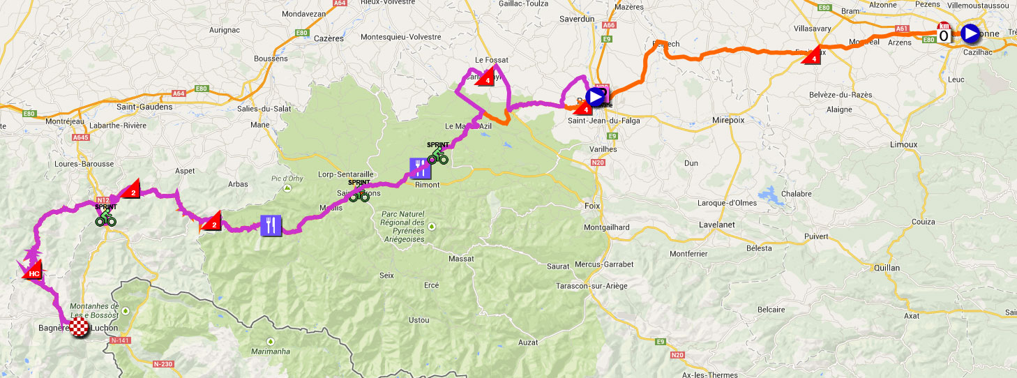