Monday 21 April 2014 at 22h24
After the Amstel Gold Race 2014 which was won by Philippe Gilbert last Sunday, the Ardennes classics continue this Wednesday with the Flèche Wallonne.
Not like last years, this race will not start west of Huy (Binche last year and Charleroi in the previous years), but from Bastogne, south-east of the finish location of this classic, to celebrate the 100th edition of Liège-Bastogne-Liège which will take place on Sunday.
In this article you'll also discover the final part of the race which has also been modified compared to last years.
CONTINUE READING AFTER THIS ADVERTISEMENT
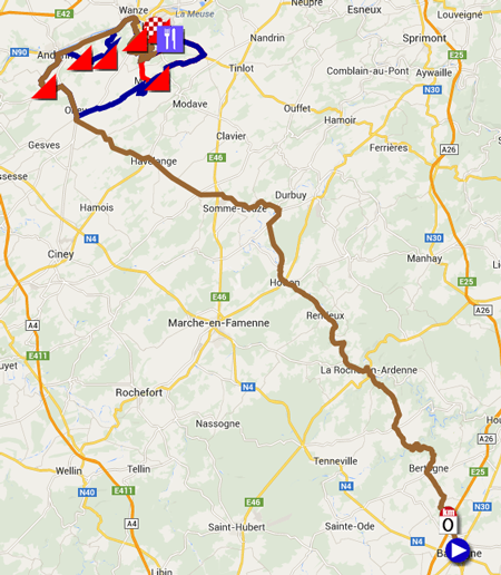
The race route of the Flèche Wallonne 2014 on Google Maps
As indicated, the race will start in Bastogne, where the Liège-Bastogne-Liège race usually turns around on the roundabout which carries its name.After the start in the Rue du Sablon, the peloton will follow the Place Saint-Pierre, the Rue Pierre Thomas, the Rue de la Roche, the aforementioned famous roundabout of La Doyenne and finally the N384 in Savy where the race will really start at 5 kilometers from the start location and where the riders will thus really start the 199 kilometer long race until the 3rd climb of the Mur de Huy.
It all starts with a first part of 111.5 kilometers towards the first climb of the Mur de Huy. From the start, the peloton visits La Roche-en-Ardenne, Hotton, Havelange and Ohey and the riders will then get on the first climb of the race, the Côte de Bellaire (1 km at 6.8%). After this first climb, their trip continues towards Andenne and then east towards Huy where the road towards the finish climb is slightly modified and goes via the Côte d'Ahin (2.1 km at 5.9%). Via Ronheuville they go back to Huy where they'll leave the N66 to geet on the famous climb of the Mur de Huy (1.3 km at no less than 9.3%). This first part of the race route is shown in brown in the map below.
After this first crossing of the finish line, the riders can get some new energy in the feeding zone in Huy and they get on the first circuit around the finish city, which is 64 long and which is shown in darkblue on the map. This first circuit around Huy is almost the same as last year and starts with the climb of the Côte d'Ereffe (2.2 km at 5.9%).
Other than last year, the race route turns right only in Ohey and the riders will then again climb the Côte de Bellaire (1 km at 6.8%). After this climb the riders will follow the race route which initially brought them to Huy but just after Andenne they briefly leave that road to climb the Côte de Bohisseau (1.3 km at 7.6%) and the Côte de Bousalle (1.7 km at 4.9%). After these two climbs the riders will return to the road which they already took for the first crossing of the finish line, up to the climb of the Mur de Huy.
The red part on the map is the second circuit around Huy, which is 23.5 kilometers long. This circuit is completely different to last year and the two last climbs of the Mur de Huy are thus now separated by only 23.5 kilometers. In this last circuit the riders will however find only one additional climb, the Côte d'Ereffe (2.2 km at 5.9%) (even though the profile seems to show another short climb just after that one), since they turn right just after this climb and get back on the road which brings them to the Mur de Huy which will, as usual, be the final judge of the Flèche Wallonne 2014!
Hereunder you'll find the race route on Maps, the profile and the time- and route schedule (with the times at which the race will cross the different cities and villages on the race route) of the Flèche Wallonne 2014. Click on the images to open them and see the details of this Ardennes classic:


The Flèche Wallonne 2014 race route in Google Earth
Would you like to see the Flèche Wallonne 2014 race route in Google Earth and for example do a virtual fly-over of the race route? Download the following KML file to do so:> Download the Flèche Wallonne 2014 race route in Google Earth

Vond u dit artikel interessant? Laat het uw vrienden op Facebook weten door op de buttons hieronder te klikken!
1 comment | 20882 views
this publication is published in: Classics | OpenStreetMap/Google Maps/Google Earth


 by marco1988 over
Un tracé Google Earth très bien réalisé compte tenu du peu d'informations sur certaines portions du parcours...