article originally published at Friday 27 June 2025 at 03:48 pm and updated on Saturday 28 June 2025 at 04:34 pm and on Saturday 28 June 2025 at 07:02 pm
The end of June is fast approaching, and so is the Tour de France 2025! The 112th edition will start in Lille, as part of the Grand Départ in the Nord de France region. For the first time in recent years, this will be a 100% French Tour de France, as it will not have a single meter outside France. However, it will also be a Tour de France with 48% transfers, as the distances between the stage finishes and the departures of the following stages is almost identical to the total distance of the Tour de France 2025, which is 3,338.8 km (the transfer distances are 3,055 km!)
You've probably already been looking forward to it: the publication with OpenStreetMap maps (equivalent to Google Maps) showing the routes of all the stages of the Tour de France 2025, zoomable as much as you like, as well as hourly itineraries and stage profiles are now available below. And, of course, the file (KML / KMZ) to open in Google Earth to visualize the entire Grand Tour, or to fly over the stages as if you were there! Now you can discover all the details of the stages that await the riders in their quest for the Yellow Jersey of the Tour de France 2025.
velowire.com once again offers you the chance to discover all the little details of the route of the Tour de France, which will be criss-crossing the roads of France for 3 weeks!
All the maps are already available as a preview in the velowire mobile app!
The maps are published here progressively, but they've already all been drawn. As you may already know, you can now find the maps for all the stages in the velowire mobile app.📲Indeed, velowire is launching its mobile app! It's still undergoing testing, but it's already available for any Android or iOS smartphone or tablet in full working version!
NEW: the application is now available on Android and iOS!
- on Android - it's easy: download the app directly from the Play Store

- on iOS (iPhone/iPad) - register to get the application - once I've received your registration, I'll give you access and tell you how to download the application.

In the mobile app, you'll be able to open the maps stage by stage, with a feature exclusively available in the app (and therefore not within this article): the ability to geolocate yourself on the map with the course, so you can determine precisely how to get there to watch the race from the roadside! (in the Maps section)
💡iPhone and/or iPad user? Good news: the velowire app will soon also be available on iOS. For the moment, you can't download it yet, but we can let you know when it's available. To be one of the first to test it on iPhone/iPad, simply fill in this form and we'll let you know (I promise, it'll only take 2 minutes 🙂)!Copyright notice
The entire content of this article (maps, timetables, descriptions, KML/KMZ files and others) is - like all content on velowire.com - protected by copyright. Consequently, its reproduction in any other form is forbidden, as specified on the copyright page. Thank you for respecting the time spent preparing content such as this! If you like this content, please promote it rather than reproduce it illegally!The program for the Grand Départ of the Tour de France 2025 in LilleAs you know, the Grand Départ of the Tour de France 2025 will take place in Lille, and more widely in the Nord de France region. Here are the dates to remember for the Grand Départ of the Tour de France 2025:
- Wednesday, July 2, 2025: opening of the welcome desk and press center at the Conseil Régional des Hauts-de-France
- Thursday July 3, 2025
- 2pm to 8pm: opening of the Fan Park on Place de la République in Lille
- 6:30pm to 8pm: presentation of the 23 Tour de France 2025 teams and their 184 riders, on the Grand'Place in Lille, preceded by a 1.1km parade through the city from the Lille Opera and going in front of the Lille Flandres train station before the trip to the Grand'Place:
- Friday, July 4, 2025: 10 a.m. to 7 p.m.: opening of the Fan Park on Place de la République in Lille
- Saturday, July 5, 2025:
- 1st stage of the Tour de France 2025 with start and finish in Lille
- from 10am to 6pm: opening of the Fan Park on Place de la République in Lille
- Sunday, July 6, 2025: stage 2 - Lauwin-Planque > Boulogne-sur-Mer
- Monday, July 7, 2025: 3rd stage - Valenciennes > Dunkirk
- Tuesday July 8, 2025: 4th stage - Amiens Métropole > Rouen
Detailed maps of all stages of the Tour de France 2025 on OpenStreetMap, hourly itineraries and stage profiles
Enough preliminary information, let's tackle the various stages of the Tour de France 2025 to discover the detailed route, on an OpenStreetMap map (similar to Google Maps), stage profiles and hourly itineraries, so you can find out around what time the caravan and the race will pass your chosen location. You'll also find details such as the precise location of the intermediate sprint, the passes and climbs that feature on the route, as well as the departments crossed and the main towns visited. Whether you're on the roadside or relaxing on your sofa in front of the TV, there's no excuse not to know the route of the Tour de France 2025.CONTINUE READING AFTER THIS ADVERTISEMENT
1/ Saturday, July 5, 2025 - Lille > Lille - 184.9 km
The very first stage of the Tour de France 2025 starts from the Citadelle of Lille. First of all, the riders will make a short detour to the official start ceremony of the Tour de France 2025, which will take place in Rue Pierre Mauroy, 2.5 km from the fictitious start. It's also to pass in front of the Conseil Régional des Hauts-de-France before heading towards Wattignies, where the real start of this stage takes place, after no less than 11 km of neutralized route. The first real kilometers of the Tour de France 2025 then take place, heading south towards Lens and the first difficulty of this 112th Tour de France, the Côte de Notre-Dame-de-Lorette (4th category). From there, the riders continue northwards, through the sprint at La Motte-au-Bois (Morbecque), past Hazebrouck, and on to the second difficulty of the day, the famous Mont Cassel (4th category). This is where the return journey to Lille begins, via the Mont Noir (4th category) as the stage's final difficulty, and Armentières, before entering the metropolis of Lille, where they follow a fairly straight course until they almost arrive at the stage's starting point, even if the finish line is just before it, on Boulevard Vauban (you could discover its location in the publication on D-100 of the Tour de France 2025, with the photo of the Mondial Relay vehicle at the traffic lights).
Below you'll find the itinerary, profile and OpenStreetMap of the first stage of the Tour de France 2025. Click on images to enlarge.


- start:
- the start will take place at the Citadelle de Lille in Lille (1:10 p.m.)
- the official start ceremony will take place in Rue Pierre Mauroy (1:15 p.m.), 2.5 km from the fictitious start and 8.5 km from the actual start
- the actual start is scheduled on the M147, 11 km from the meeting point (13h40)
- altitude gain: 1,150 m, with 4.2 km of difficulty listed as passes and climbs:
- Côte de Notre-Dame-de-Lorette (4th category) at km 41.2 - ^ 165 m / 1 km at 7.6
- Mont Cassel (4th category) at km 106 - ^ 144 m / 1.9 km at 3.5%.
- Mont Noir (4th category) at km 139.7 - ^ 143 m / 1.3 km at 6.4%.
- intermediate sprint: Rue de Merville in La Motte-au-Bois (Morbecque) at km 87.5
- finish: Boulevard Vauban in Lille, at the end of a 1.4 km / 7 m wide final straight.
- departments crossed: Nord (59) from km 0 to km 10.8 and from km 78.1 to km 184.9, Pas-de-Calais (62) from km 12.5 to km 72.7
- main towns: Lille, Seclin, Carvin, Lens, Noeux-les-Mines, Béthune, Hazebrouck, Cassel, Bailleul, Armentières, then Lille again
2/ Sunday, July 6, 2025 - Lauwin-Planque > Boulogne-sur-Mer - 209.1 km
South of Lille, the start of the second stage takes place in Lauwin-Planque, close to Douai, and the riders then head for Arras before continuing westwards. With around 100km to go, they climb a first difficulty before continuing to the intermediate sprint and reaching the climb at Etaples. In the last 30km of the stage, they then have to climb 3 difficulties, two of which are 3rd category, and even the finish in Boulogne-sur-Mer is uphill (1.2km at 3.8%).
Below you'll find the time schedule, profile and OpenStreetMap of the second stage of the Tour de France 2025. Click on images to enlarge.


- start:
- the start will be at Rue du Marais in Lauwin-Planque (12:15 p.m.)
- the actual start is on the D956, 9.5 km from the meeting point (12:35 p.m.)
- altitude gain: 2,550 m, with 4 km of difficulty listed as passes and climbs:
- Côte de Cavron-Saint-Martin (4th category) at km 104.3 - ^ 104 m / 1.1 km at 5.9
- Côte du Haut Pichot (3rd category) at km 179.3 - ^ 179 m / 1.1 km at 9.4%.
- Côte de Saint-Etienne-au-Mont (3rd category) at km 200.4 - ^ 111 m / 1 km at 10.6%.
- Côte d'Outreau (4th category) at km 203.8 - ^ 86 m / 800 m at 8.8%.
- intermediate sprint: Rue Nationale in Enocq (Bréxent-Enocq) at km 154.6
- finish: Boulevard Auguste Mariette in Boulogne-sur-Mer, at the end of a 100 m finishing straight and a 1.2 km climb at 3.8% / width 6 m
- departments crossed: Nord (59) from km 0 to km 1 and km 4.9, Pas-de-Calais (62) at km 3.9 and km 6.1 to km 209.1
- main towns: Douai, Arras, Etaples and Boulogne-sur-Mer
 QG Intermarché-Wanty: this year, the Intermarché-Wanty WorldTour team is staging a special event with its "Supporters' HQ" in the form of a guinguette. Fans of cycling and the team can enter free of charge to take on sporting challenges, sample local produce, discover the team's universe and cheer on the riders together. It takes place over 4 stages: the 2nd (this one), the 7th, the 11th and the 16th, and you can immerse yourself in the team's universe: discover the riders' favorite recipes, their culinary advice as top sportsmen and women, listen to their playlists, immerse yourself in their daily sporting life, discover the very complementary profiles of each rider, and at certain times meet members of the team.
"DU BOIS VINCENT" - 66 Rue Sadi Carnot - 62223 Anzin-Saint-Aubin at km 34
open : from 10am till 18pm
advertising caravan : 11.24am
race : 1.19pm
3/ Monday, July 7, 2025 - Valenciennes > Dunkirk - 178.3 km
The third stage will start at about the same height as the previous one, but further east, in Valenciennes. Passing between Lille and Lens, the riders then head for the intermediate sprint in Isbergues, before continuing via Hazebrouck to Mont Cassel and the finish in Dunkirk.
Below you'll find the time schedule, profile and OpenStreetMap for the third stage of the Tour de France 2025. Click on images to enlarge.


- start:
- the start will be on boulevard Pater in Valenciennes (1:10pm)
- the actual start is on the D375, 6.6 km from the assembly point (1:25 p.m.)
- altitude gain: 800 m, with 2.3 km of difficulty listed as passes and climbs:
- Mont Cassel (4th category) at km 147.4 - ^ 144 m / 2.3 km at 3.8
- intermediate sprint: Rue Verte in Isbergues at km 118.2
- finish: Rue de la Cunette in Dunkerque, at the end of a 1.5 km final straight (including 200 m at sight) / width 6 m
- departments crossed: Nord (59) from km 0 to km 75.1 and from km 127.2 to km 178.3, Pas-de-Calais (62) from km 77.5 to km 126.7
- main towns: Valenciennes, Saint-Amand-les-Eaux, Béthune, Lillers, Isbergues, Dunkerque
4/ Tuesday, July 8, 2025 - Amiens > Rouen - 174.2 km
Stage 4 from Amiens will be the last stage of the Grand Départ of the Tour de France 2025. Gone are the routes through the departments of Nord and Pas-de-Calais, for a route that heads south-west through the Somme and l'Oise to Normandy. Arriving in Les Andelys, the riders turn west towards the finish. Before they reach the finish, however, there are no fewer than 5 difficulties and the intermediate sprint on their route, with the last two climbs in the finishing town of Rouen, 12.1 and 5.2 km from the finish respectively. The finish itself will be preceded by a 500 m climb at 5%, followed by 300 m on the flat.
Below you'll find the time schedule, profile and OpenStreetMap of the fourth stage of the Tour de France 2025. Click on images to enlarge.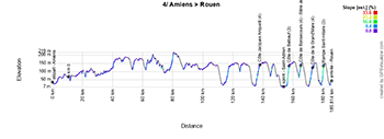


- start:
- the start will be on rue de la République in Amiens (1:15pm)
- the actual start is on the D210 / route de Beauvais in Vers-sur-Selle, 10.5 km from the assembly point (1:35 p.m.)
- altitude gain: 2,050 m, with 8.3 km of difficulty listed as passes and climbs:
- Côte Jacques Anquetil (4th category) at km 128.2 - ^ 149 m / 3.5 km at 3.6
- Côte de Belbeuf (3rd category) at km 146.6 - ^ 136 m / 1.3 km at 9.1%.
- Côte de Bonsecours (Stèle Jean Robic) (4th category) at km 154.4 - ^ 135 m / 900 m at 7.2%.
- Côte de la Grand'Mare (4th category) at km 162.1 - ^ 124 m / 1.8 km at 5%.
- Rampe Saint-Hilaire (3rd category) at km 169 - ^ 131 m / 800 m at 10.6%.
- intermediate sprint: Route de Paris in Saint-Adrien (Belbeuf) at km 143.3
- finish: Boulevard de l'Yser in Rouen, at the end of a final 250 m straight at sight / width 6 m
- departments crossed: Somme (80) from km 0 to km 16.3, Oise (60) from km 18 to km 58.4, Seine-Maritime (76) from km 62.4 to km 71.6 and from km 128.1 to km 174.2, Eure (27) from km 76.2 to km 124.4
- main towns: Amiens, Crèvecoeur-le-Grand, Ferrières-en-Bray, Les Andelys, Romilly-sur-Andelle, Rouen
CONTINUE READING AFTER THIS ADVERTISEMENT
5/ Wednesday, July 9, 2025 - Caen > Caen - individual time trial - 33 km
It's time for an individual time trial on stage 5, which will virtually be a loop, starting and finishing in Caen. From the start ramp, each rider will head north-west through the intermediate timing point at Cambes-en-Plaine to Colombay-sur-Thaon, before turning left through the intermediate timing point at Thaon. A little further on, each rider will then turn left again in their solitary effort, to begin the return route which passes through the Gruchy intermediate timing point, before re-entering the city of Caen.
Below you'll find the time itinerary, profile and OpenStreetMap of the route of the fifth stage of the Tour de France 2025. Click on images to enlarge.


- start:
- the start ramp is on boulevard des Alliés in Caen (first rider at 1:05 pm, last rider at 5:00 pm)
- elevation gain: 200 m, no difficulties listed passes and climbs
- finish: Cours Général de Gaulle in Caen, at the end of a 370 m / 5 m wide finishing straight
- departments crossed: Calvados (14) from km 0 to km 33
- main towns: Caen
6/ Thursday, July 10, 2025 - Bayeux > Vire Normandie - 201.5 km
Like the previous one, stage 6 will also take place entirely in Normandy. This time, however, it will be a road stage, starting from Bayeux. From there, the riders head south to the intermediate sprint at Villers-Bocage, and then on to the first two difficulties of the stage. After the last of these, they turn right to head via Flers to Barenton. Here they turn right again, heading for the final part of this 6th stage of the Tour de France 2025. They first encounter a series of three 3rd-category difficulties before heading for the town of Vire. There, they make a final loop to the east of the town, to pick up a final climb, this time of 4th category, whose summit lies 4.4 km from the finish line, while the road to the finish itself also climbs, for 700 meters at 10.2%.
Below you'll find the time itinerary, profile and OpenStreetMap of the route of stage 6 of the Tour de France 2025. Click on images to enlarge.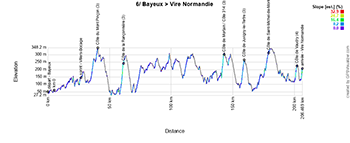


- start:
- the start will be at Rue Alain Chartier in Bayeux (12:35 p.m.)
- the actual start is on the D67, 5.2 km from the meeting point (12:45 p.m.)
- altitude gain: 3,550 m, with 16.6 km of difficulty listed as passes and climbs:
- Côte du Mont Pinçon (3rd category) at km 35.5 - ^ 353 m / 5.6 km at 3.7% gradient
- Côte de la Rançonnière (3rd category) at km 56 - ^ 216 m / 2.2 km at 7.9%
- Côte de Mortain / Côte 314 (3rd category) at km 138 - ^ 310 m / 1.6 km at 9.5%
- Côte de Juvigny-le-Tertre (3rd category) at km 154.5 - ^ 270 m / 2.2 km at 7.3%
- Côte de Saint-Michel-de-Montjoie (3rd category) at km 174.3 - ^ 331 m / 3.7 km at 4.5%
- Côte de Vaudry (4th category) at km 197.1 - ^ 225 m / 1.2 km at 7.2%
- Intermediate sprint: Rue d'Aunay in Villers-Bocage at km 22.2
- finish: Avenue de l'Atlacomulco in Vire, at the end of a final 100 m straight at sight and at the end of a 700 m climb at 10.2% / width 5.50 m
- departments crossed: Calvados (14) from km 0 to km 65.4 and from km 177.9 to km 201.5, Orne (61) from km 68 to km 104.1, Manche from km 111.9 to km 174.9
- main towns: Bayeux, Villers-Bocage, Flers, Mortain and Vire
7/ Friday, July 11, 2025 - Saint-Malo > Mûr-de-Bretagne (Guerlédan) - 197 km
Stage 7 of the Tour de France 2025 will be in Brittany, starting from Saint-Malo. The stage heads south, passing through Dinan. The riders then head northwest again, reaching the coast at Pléneuf-Val-André. On the way to Saint-Brieuc, they pass through Yffiniac, the birthplace of five-time Tour de France winner Bernard Hinault, 70 years ago, but this is unlikely to be a concern for the puncheurs who have marked this stage for its already legendary finish. After Saint-Brieuc, they contest the intermediate sprint at Plédran before continuing south to Mûr-de-Bretagne. By the time they reach the village, they will have already climbed a first hill, before arriving on a final circuit, which sees them climb the final difficulty of Mûr-de-Bretagne (Guerlédan) twice.
Below you'll find the time itinerary, profile and OpenStreetMap of the seventh stage of the Tour de France 2025. Click on images to enlarge.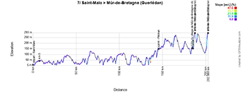


- start:
- the start will be on Chaussée du Sillon / D137 in Saint-Malo (12:10pm)
- the actual start is on the D6, 7.4 km from the assembly point (12:25 p.m.)
- altitude gain: 2,450 m, with 5.6 km of difficulty listed as passes and climbs:
- Côte du village de Mûr-de-Bretagne (4th category) at km 178.8 - ^ 182 m / 1.6 km at 4.1%
- Mûr-de-Bretagne (3rd category) twice, at km 181.7 and km 197 - ^ 293 m / 2 km at 6.9%
- intermediate sprint: Rue des Lilas in Plédran at km 139.2
- finish: D767 at Mûr-de-Bretagne, at the end of a 300 m straight finish at sight / width 6 m
- departments crossed: Ille-et-Vilaine (35) from km 0 to km 16.9 and from km 34.7 to km 42, Côtes-d'Armor (22) from km 17 to km 32.8 and from km 44.8 to km 197
- main towns: Saint-Malo, Dinan, Pléneuf-Val-André, Saint-Brieuc and Mûr-de-Bretagne
 QG Intermarché-Wanty (see explanation at stage 2):
19 ZA de la Croix Cabaret, 22150 SAINT CARREUC at km 139.2
open: from 12.30pm at 6.30pm
advertising caravan: 1.52pm
race: 3.35pm
8/ Saturday, July 12, 2025 - Saint-Méen-le-Grand > Laval - 171.4 km
Stage 8 also starts in Brittany, from Saint-Méen-le-Grand and passes over Rennes on its way to the intermediate sprint at Vitré. From there, the riders head south to Craon and Lagné, where they turn left to head north towards the finish line. It's more of a transition stage, but there will be a small 4th category difficulty, topping out 16.4km from the finish in Laval at l'Espace Mayenne, which should still be a bunch sprint.
Below you'll find the time schedule, profile and OpenStreetMap of the eighth stage of the Tour de France 2025. Click on images to enlarge.


- start:
- the start will be at Place du Stade in Saint-Méen-le-Grand (1:10pm)
- the actual start is on the D125, 6.4 km from the assembly point (1:25 p.m.)
- altitude gain: 1,700 m, with 900 m of difficulty listed as passes and climbs:
- Côte de Nuillé-sur-Vicoin (4th category) at km 155 - ^ 96 m / 900 m at 3.8
- intermediate sprint: Promenade Saint-Yves in Vitré at km 85.5
- finish: Boulevard Pierre Elain (D900) in Laval, at the end of a 1.5 km final straight (of which 200 m at sight) / width 6.50 m
- departments crossed: Ille-et-Vilaine (35) from km 0 to km 102.8, Mayenne (53) from km 104.7 to km 171.4
- main towns: Saint-Méen-le-Grand, Liffré, Vitré, Craon, Laval
CONTINUE READING AFTER THIS ADVERTISEMENT
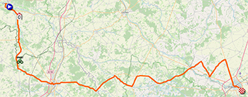
9/ Sunday, July 13, 2025 - Chinon > Châteauroux - 174.1 km
A new stage for sprinters awaits the riders on this second weekend of the Tour de France 2025, starting from Chinon in Indre-et-Loire. Soon after the start, the race joins the Vienne, where the stage's intermediate sprint will be held. At Orches, the descent to the south stops, before turning left and heading east via Châtellerault, before returning to Indre-et-Loire and arriving in Indre to head for the finish in Châteauroux. No difficulties are officially listed on the route of this stage, so the sprint teams should be able to organize themselves to take victory in the place where Mark Cavendish has shone 3 times (in 2008, 2011 and 2021)!
Below you'll find the time schedule, profile and OpenStreetMap of the route of the ninth stage of the Tour de France 2025. Click on images to enlarge.

- start:
- the start will be at Quai Jeanne d'Arc in Chinon (1:10pm)
- the actual start is on the D749, 7.6 km from the assembly point (1:25 p.m.)
- altitude gain: 1,400 m, with no listed difficulties as passes and climbs
- intermediate sprint: D757 at La Belle Indienne (Sérigny) at km 24.2
- finish: Avenue de la Châtre in Châteauroux, at the end of a 1.6 km / 6 m wide final straight
- departments crossed: Indre-et-Loire from km 0 to km 20.7 and from km 75.8 to km 88.8, Vienne from km 23.8 to km 72.5, Indre from km 93.3 to km 174.1
- main towns: Chinon, Châtellerault, La Roche-Posay, Buzançais, Châteauroux
10/ Monday, July 14, 2025 - Ennezat > Le Mont-Dore Puy de Sancy - 165.3 km
The last stage of this long weekend (for it is a long weekend, with the national holiday on Monday July 14!) is more in keeping with what you'd expect to see from a stage on a weekend and during peak TV viewing times (and even at the roadside, for that matter).
At the start in Ennezat, the riders know that there are no less than 8 difficulties awaiting them, all - with one exception - 2nd category, including the final climb! The actual start of the stage will be given in Riom, and the riders will then already find a first difficulty, before heading towards Volvic, then the intermediate sprint to Durtol and Clermont-Ferrand. They then head for the Puy de Dôme, but don't climb it (otherwise the stage would end there), but turn instead around Clermont-Ferrand and through the beautifully undulating and verdant Circuit de Charade. It was on this circuit that the film Grand Prix was shot (in part), and where Laurent Jalabert won the French Championship in 1998. The race will take in the southern part of the circuit before leaving it in the direction of Ceyrat and Saint-Bonnet-près-Orcival. Remaining in volcanic country, the difficulties continue to mount, and it's via Chambon-le-Lac and Murol that the riders approach the finish, climbing one more pass before beginning the final ascent to Le Mont-Dore Puy de Sancy.
Below you'll find the time schedule, profile and OpenStreetMap of the tenth stage of the Tour de France 2025. Click on images to enlarge.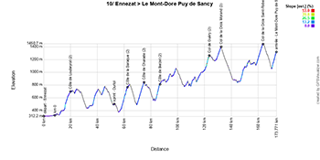

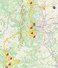
- start:
- the start will be at Rue de la République in Ennezat (1:10pm)
- the actual start is on Route d'Ennezat (D204) in Riom, 8.3 km from the assembly point (1:25 p.m.)
- altitude gain: 4,450 m, with 32.6 km of difficulty listed as passes and climbs:
- Côte de Loubeyrat (2nd category) at km 11.8 - ^ 707 m / 4.1 km at 6.3
- Côte de la Baraque (2nd category) at km 54.5 - ^ 788 m / 4.8 km at 7.4%.
- Côte de Charade (2nd category) at km 62.4 - ^ 850 m / 5.1 km at 6.8%
- Côte de Berzet (2nd category) at km 78.4 - ^ 818 m / 3.4 km at 7.4%
- Col de Guéry (2nd category) at km 115.4 - ^ 1,268 m / 3.4 km at 6.7%
- Col de la Croix Morand (3rd category) at km 124.1 - ^ 1,401 m / 3.4 km at 5.7%
- Col de la Croix Saint-Robert (2nd category) at km 155.4 - ^ 1,451 m / 5.1 km at 6.4%
- Le Mont-Dore Puy de Sancy (2nd category) at km 165.3 - ^ 1,324 m / 3.3 km at 8%
- intermediate sprint: Avenue de Pontgibaud (M943) in Durtol at km 44.4
- finish: Route du Sancy (D983) in Le Mont Dore, at the end of a 110 m straight final stretch at sight / width 6 m
- departments crossed: Puy-de-Dôme (63) from km 0 to km 165.3
- main towns: Ennezat, Riom, Volvic, Clermont-Ferrand, Ceyrat, Rochefort-Montagne, Chambon-sur-Lac, Murol, Mont-Dore
R1/ Tuesday July 15, 2025 - rest in Toulouse
After this long initial period of the Tour de France 2025, it's finally on Tuesday, July 15, that the riders will be able to enjoy the very first rest day. Before that, another transfer (there have been quite a few before) will be necessary, to arrive in Toulouse.11/ Wednesday, July 16, 2025 - Toulouse > Toulouse - 156.8 km
The day after the first rest day, stage 11 takes place in a loop around Toulouse. From the south of the pink city, the race climbs northwards, encountering its first 4th category difficulty at Castelnau-d'Estrétefonds, by which time the riders have almost reached the northernmost point of the stage. Heading south, they then skirt Toulouse to the east, until the sprint at Labastide-Beauvoir. On the way back to Toulouse, they follow roads with several difficulties: 3 in 4th category and the last in 3rd category, with the Côte de Pech David, whose summit lies 8.8 kilometers from the finish. It has gradients of up to 20%, and could see the strongest riders selected to avoid a sprint finish on Boulevard Lascrosses.
Below you'll find the time schedule, profile and OpenStreetMap for the eleventh stage of the Tour de France 2025. Click on images to enlarge.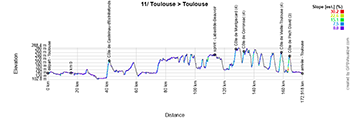

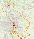
- start:
- the start will take place on the parvis du Stadium in Toulouse (1:15pm)
- the actual start is on the Chemin de Bel Air in Seilh, 16.5 km from the assembly point (1:45 p.m.)
- altitude gain: 1,750 m, with 6 km of difficult climbs and passes:
- Côte de Castelnau-d'Estrétefonds (4th category) at km 25.9 - ^ 218 m / 1.4 km at 6.6
- Côte de Montgiscard (4th category) at km 111.6 - ^ 282 m / 1.6 km at 5.3%.
- Côte de Corronsac (4th category) at km 117 - ^ 267 m / 900 m at 6.7%.
- Côte de Vieille-Toulouse (4th category) at km 117 - ^ 257 m / 1.3 km at 6.8%.
- Côte de Pech David (3rd category) at km 148 - ^ 249 m / 800 m at 12.4%.
- intermediate sprint: Route de Toulouse in Labastide-Beauvoir at km 97.3
- finish: Boulevard Lascrosses in Toulouse, at the end of a final straight 500 m at sight / width 6 m
- departments crossed: Haute-Garonne (31) from km 0 to km 156.8
- main towns: Toulouse, Blagnac, Castelnau-d'Estrétefonds, Labastide-Beauvoir, Castanet-Tolosan then Toulouse again
 QG Intermarché-Wanty (see explanation at stage 2):
65 Route d'Albi - 31180 CASTELMOUROU au km 59.6
open: from 11am till 6pm
advertising caravan: 1.08pm
race: 3.01pm
CONTINUE READING AFTER THIS ADVERTISEMENT
12/ Thursday, July 17, 2025 - Auch > Hautacam - 180.6 km
From Auch, the 12th stage of the Tour de France 2025 will be its first Pyrenean stage. After around 100 km, the riders will see the road rise for real (just before that, they will have climbed a 4th-category climb), and will then have two major cols to contend with, with a small col in the middle, and with the final col being the high-altitude finish.
The first of these will be the 1st-category Col du Soulor, whose descent will be interrupted at Arrens by turning onto the ascent of the Col des Bordères, a 2nd-category col. After the descent to Argelès-Gazost, a giant then rises in front of them, with the climb to Hautacam, arriving at altitude on a outside-category pass. If it hasn't been the case before, it's certainly here that the men in the general classification will stand out!
Below you'll find the time schedule, profile and OpenStreetMap of the twelfth stage of the Tour de France 2025. Click on images to enlarge.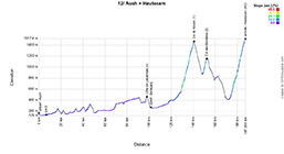

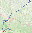
- start:
- the start will be on rue d'Étigny in Auch (1:10pm)
- the actual start is on the N21 at Pavie, 6.8 km from the meeting point (1:25 p.m.)
- altitude gain: 3,850 m, with 29.7 km of difficulty listed as passes and climbs:
- Côte de Labatmale (4th category) at km 91.4 - ^ 470 m / 1.3 km at 6.3
- Col du Soulor (1st category) at km 134.1 - ^ 1,474 m / 11.8 km at 7.3
- Col de Bordères (2nd category) at km 145.7 - ^ 1,156 m / 3.1 km at 7.7%.
- Hautacam (non-category) at km 180.6 - ^ 1,520 m / 13.5 km at 7.8%.
- intermediate sprint: Rue des Pyrénées in Bénéjacq at km 95.1
- finish: at the Hautacam main parking lot (D100), at the end of a 70 m straight final stretch at sight / width 5.50 m
- departments crossed: Gers (32) from km 0 to km 43.3, Hautes-Pyrénées (65) from km 47.2 to km 58.6 and from km 66.3 to km 70.3 and from km 122.3 to km 180.6, Pyrénées-Atlantiques (64) at km 64 and from km 74.1 to km 118.6
- main towns: Auch, Rabastens-de-Bigorre, Vic-en-Bigorre, Nay, Coarraze, Artens-Marsous, Argelès-Gazost, Hautacam
13/ Friday, July 18, 2025 - Loudenvielle > Peyragudes - individual time trial - 10.9 km
Stage 13, on the eve of the 3rd weekend of the Tour de France 2025, will still be a Pyrenean stage, and what a stage it will be! In the Giro d'Italia, the Italians call it a cronoscalata, i.e. an uphill individual time trial, and that's exactly what it's all about, because after about 3 km on the flat from the start in Loudenvielle, and after a gradual uphill part, it's at the first intermediate timing point in Escadaoux that the road rises sharply. In total, the climb is 8 km at 7.9%, all the way to the Peyresourde-Balestas Altiport in Peyragudes, where each rider will finish his solo effort on the runway of the altiport, which was transformed into an Afghan base in 1997 during the filming of the James Bond movie Tomorrow Never Dies (see this report or this one).
Below you'll find the timetable, profile and OpenStreetMap for the thirteenth stage of the Tour de France 2025. Click on images to enlarge.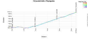

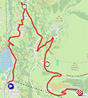
- start:
- the start ramp will be located in the Allée Laurent Brochard in Loudenvielle, with starts first every minute, then every 1'30", and finally every 2 minutes for the last competitors (first rider starts at around 1:10pm [depending on the number of riders remaining], last rider starts at 5:05pm)
- altitude gain: 650 m, with 8 km of difficulty listed as passes and climbs:
- Peyragudes (1st category) at km 10.9 - ^ 1,580 m / 8 km at 7.9%
- finish: Altiport de Peyresourde-Balestas in Peyragudes, at the end of a 400 m final straight, 100 m of which is on sight / width 6 m
- departments crossed: Hautes-Pyrénées (65) from km 0 to km 10.9
- main towns: Loudenvielle, Loudervielle and Peyragudes / Peyresourde-Balestas
14/ Saturday, July 19, 2025 - Pau > Luchon-Superbagnères - 182.6 km
The 14th stage of the 3rd Saturday of the Tour de France 2025 is a further extension of the Pyrenean sojourn, starting from the unmissable town of Pau. The first 70km, up to the intermediate sprint at Esquièze-Sère, are very slightly uphill, but it's from here on that the stage takes on a real mountainous aspect, with a series of cols up to the finish at altitude.
The riders will have to tackle the Col du Tourmalet (hors catégorie), the Col d'Aspin (2e catégorie), the Col de Peyresourde (1ère catégorie, which they had already partially climbed in the previous day's time trial) and finally the climb to the finish in Luchon-Superbagnères (hors catégorie).
Below you'll find the time schedule, profile and OpenStreetMap of the fourteenth stage of the Tour de France 2025. Click on images to enlarge.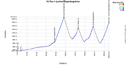

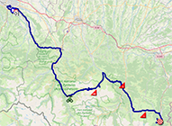
- start:
- the start will be on Avenue Gaston Lacoste in Pau (12:00)
- the actual start is on the D802 in Bizanos, 7.5 km from the assembly point (12:15 p.m.)
- altitude gain: 4,950 m, with 43.5 km of difficulty listed as climbs and passes:
- Col du Tourmalet (hors catégorie, Souvenir Jacques Goddet) at km 89.5 - ^ 2,115 m / 19 km at 7.4
- Col d'Aspin (2nd category) at km 119.3 - ^ 1,489 m / 5 km at 7.6%
- Col de Peyresourde (1st category) at km 150.1 - ^ 1,569 m / 7.1 km at 7.8%
- Luchon-Superbagnères (outside category) at km 182.6 - ^ 1,804 m / 12.4 km at 7.3%
- intermediate sprint: Avenue du Barège in Esquièze-Sère at km 70.1
- finish: D46 at Luchon-Superbagnères, at the end of a final 80 m straight line at sight / width 5.50 m
- departments crossed: Pyrénées-Atlantiques (64) from km 0 to km 24.5, Hautes-Pyrénées (65) from km 27.3 to km 150.1, Haute-Garonne (31) from km 155.8 to km 182.6
- main towns: Pau, Lourdes, Argelès-Gazost, Pierrefitte-Nestalas, Luz-Saint-Sauveur, Loudervielle, Montauban-de-Luchon, Luchon-Superbagnères
15/ Sunday July 20, 2025 - Muret > Carcassonne - 169.3 km
On the second day of the weekend, we're already out of the Pyrenees, but there's no guarantee that the stage from Muret will finish in a sprint. The Côte de Saint-Ferréol and the Côte de Sorèze, both 3rd category, shouldn't leave too many traces, but the Pas du Sant is a steeper climb, 2nd category, and when the riders reach the banner marking the top of this climb, they won't be finished for all that... For the next ten kilometers or so, the route continues to climb more gently, before heading downhill for forty kilometers or so, until the finish in Carcassonne.
Below you'll find the time schedule, profile and OpenStreetMap of the route for stage 15 of the Tour de France 2025. Click on images to enlarge.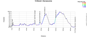

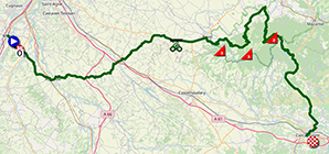
- start:
- the start will be at Place Léon Blum in Muret (1:20pm)
- the actual start is on the D12, 3.4 km from the assembly point (1:30 p.m.)
- altitude gain: 2,400 m, with 10.8 km of difficulty listed as passes and climbs:
- Côte de Saint-Ferréol (3rd category) at km 72.8 - ^ 350 m / 1.7 km at 7% gradient
- Côte de Sorèze (3rd category) at km 86.6 - ^ 702 m / 6.2 km at 5.5%
- Pas du Sant (2nd category) at km 116.6 - ^ 610 m / 2.9 km at 10.2%
- intermediate sprint: Route de Toulouse in Saint-Félix-Lauragais at km 59.8
- finish: Boulevard Marcou in Carcassonne, at the end of a final 200 m straight at sight / width 6 m
- departments crossed: Haute-Garonne (31) from km 0 to km 72.8, Tarn (81) from km 73.2 to km 127.3, Aude (11) from km 128.4 to km 169.3
- main towns: Muret, Auterive, Villefranche-de-Lauragais, Saint-Félix-Lauragais, Revel, Carcassonne
CONTINUE READING AFTER THIS ADVERTISEMENT
R2/ Monday July 21, 2025 - rest in Montpellier
After a transfer from Carcassonne to Montpellier, it's here, near the sea, that the riders and followers of the Tour de France 2025 will be able to rest after a second week of hard racing, particularly with the extended passage through the Pyrenees.16/ Tuesday, July 22, 2025 - Montpellier > Mont Ventoux - 171.5 km
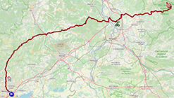
The day after the final rest day of the Tour de France 2025, the riders set off from Montpellier on stage 16. Bypassing Nîmes and Avignon on the north side, they arrive at the intermediate sprint in Châteauneuf-du-Pape. It's only some twenty kilometers later that the road rises, timidly at first, then more forcefully from Bédoin, where the real climb of difficulty begins, marking this stage as it has done with others on the Tour de France (everyone remembers Chris Froome on foot in 2016! [that was the last time the Tour de France had a stage finish on top]): the Mont Ventoux.
Below you'll find the itinerary, profile and OpenStreetMap of the sixteenth stage of the Tour de France 2025. Click on images to enlarge.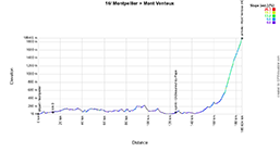

- start:
- the start will be at Esplanade de l'Europe in Montpellier (12.10pm)
- the actual start is on the M17 in Prades-le-Lez, 13.2 km from the assembly point (12:40 p.m.)
- altitude gain: 2,950 m, with 15.7 km of difficulty listed as cols and côtes:
- Mont Ventoux (out of category) at km 171.5 - ^ 1,910 m / 15.7 km at 8.8%
- intermediate sprint: Avenue Saint-Joseph in Châteauneuf-du-Pape at km 112.4
- finish: D9740 at Mont Ventoux, at the end of a final 80 m straight line at sight / width 4.50 m
- departments crossed: Hérault (34) from km 0 to km 17.2, Gard (30) from km 20.5 to km 104.3, Vaucluse (84) from km 107.5 to km 171.5
- main towns: Montpellier, Roquemaure, Courthézon, Bédoin
 QG Intermarché-Wanty (see explanation at stage 2):
620 Rte de Carpentras - 84410 BEDOIN at km 149.2
open: from 12.30pm till 6.30pm
advertising caravan: 2.13pm
race: 3.55pm
17/ Wednesday, July 23, 2025 - Bollène > Valence - 160.4 km
One of the last opportunities for sprinters will present itself this Wednesday, July 22, at the start in Bollène. Although two 4th category climbs will punctuate this stage, they shouldn't prevent the sprinters' teams from organizing themselves for a massive finish ... unless the wind gets in the way and creates breaking groups!
Below you'll find the time itinerary, profile and OpenStreetMap of the route of the seventeenth stage of the Tour de France 2025. Click on images to enlarge.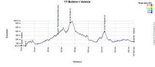


- start:
- the start will be on Cours de la République in Bollène (1:35pm)
- the actual start is on the D152 in Mondragon (1:50pm)
- elevation gain: 1,650 m, with 7.3 km of difficulty listed as passes and climbs:
- Col du Pertuis (4th category) at km 66.3 - ^ 632 m / 3.7 km at 6.6%
- Col de Tartaiguille (4th category) at km 117 - ^ 406 m / 3.6 km at 3.5%
- intermediate sprint: Route de Nyons à Roche-Saint-Secret-Béconne at km 47.9
- finish: Boulevard Franklin Roosevelt in Valence, at the end of a 600 m straight finish at sight / width 6.50 m
- departments crossed: Vaucluse (84) from km 0 to km 8.4, Drôme (26) from km 10.3 to km 160.4
- main towns: Bollène, Grane, Valence
18/ Thursday, July 24, 2025 - Vif > Courchevel Col de la Loze - 171.5 km
After this stage for sprinters, it's a real mountain stage that starts in Vif on Thursday. The first 40 km of the stage, including the intermediate sprint at Rioupéroux (Livet-et-Gavet), give the riders a moment's respite, but after that, the stage will be punctuated by the ascent of 3 out-of-category passes: Col du Glandon, Col de la Madeleine and the final climb from Brides-les-Bains to the Col de la Loze, above Courchevel. This will be the roof of the Tour de France 2025 and the rider who wins this stage also takes the prize associated with the Souvenir Henri Desgrange.
Below you'll find the time schedule, profile and OpenStreetMap of the eighteenth stage of the Tour de France 2025. Click on images to enlarge.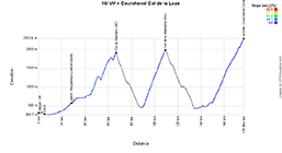

- start:
- the start will be on Boulevard de la Résistance in Vif (12.10pm)
- the actual start is on the D529, 4.6 km from the assembly point (12:20 p.m.)
- altitude gain: 5,450 m, with 65.3 km of difficulty listed as cols and côtes:
- Col du Glandon (out of category) at km 62.3 - ^ 1,924 m / 21.7 km at 5.1%
- Col de la Madeleine (non-category) at km 104.6 - ^ 2,000 m / 19.2 km at 7.9%
- Col de la Loze (non-category) at km 171.5 - ^ 2,304 m / 26.4 km at 6.5%
- intermediate sprint: Route des Alpes at Rioupéroux (Livet-et-Gavet) at km 23.7
- finish: Route du col de la Loze at col de la Loze (Courchevel), at the end of an 80 m / 4 m wide final straight
- departments crossed: Isère (38) from km 0 to km 55.8, Savoie (73) from km 58.8 to km 171.5
- main towns: Vif, Allemond, Oz, La Chambre, Bellecombe, Moûtiers, Salins-les-Thermes, Brides-les-Bains, Saint-Bon-Tarentaise, Courchevel
CONTINUE READING AFTER THIS ADVERTISEMENT
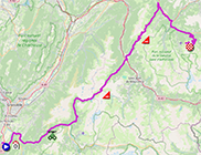
19/ Friday, July 25, 2025 - Albertville > La Plagne - 129.9 km
Albertville is the starting point for a short but explosive stage, with no fewer than 5 difficulties in less than 130 kilometers, including 2 out-of-category, one 1st category and two 2nd category.
After the intermediate sprint in Ugine, just 8 kilometers after the start, the road rises for the climb up Côte d'Héry-sur-Ugine (2nd category), followed by a short descent and the climb up the Col des Saisies (1st category), while after the descent of the latter, the Col du Pré (out-of-category) already awaits the riders. A short descent to the magnificent lake, followed by another climb, takes the riders to Cormet de Roselend (2nd category), before leaving this part of the mountain area via Bourg-Saint-Maurice for the plain and the final climb to La Plagne (out-of-category) starting at Mâcon-la-Plagne.
Below you'll find the time schedule, profile and OpenStreetMap for the nineteenth stage of the Tour de France 2025. Click on images to enlarge.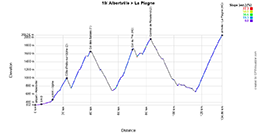

- start:
- the start will take place at the Henry Dujol Olympic Park in Albertville (1:30pm)
- the actual start is on the D1212, 4.6 km from the assembly point (1:40 p.m.)
- altitude gain: 4,550 m, with 62.6 km of difficulty listed as passes and climbs:
- Côte d'Héry-sur-Ugine (2nd category) at km 18.3 - ^ 1,004 m / 11.3 km at 5.1%
- Col des Saisies (1st category) at km 35.1 - ^ 1,650 m / 13.7 km at 6.4%
- Col du Pré (out-of-category) at km 66 - ^ 1,748 m / 12.6 km at 7.7%
- Cormet de Roselend (2nd category) at km 78.5 - ^ 1,968 m / 5.9 km at 6.3%
- La Plagne (out-of-category) at km 129.9 - ^ 2,052 m / 19.1 km at 7.2%
- intermediate sprint: Avenue André Pringolliet in Ugine at km 8
- finish: Route du Boulevard (D223) in La Plagne, at the end of a final straight 50 m at sight / width 5 m
- departments crossed: Savoie (73) from km 0 to km 129.9
- main towns: Albertville, Ugine, Les Saisies, Beaufort, Bourg-Saint-Maurice, Aime, Mâcon-la-Plagne, La Plagne
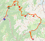
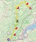
20/ Saturday, July 26, 2025 - Nantua > Pontarlier - 184.2 km
The penultimate stage of the Tour de France 2025 is a little off the beaten track compared with previous stages in the Alps, as it takes place in the Ain and Jura regions. The start is in Nantua, and the stage skirts Switzerland, exposing the riders to 4 difficulties: two in the first part and two in the last part of the stage. Soon enough, they climb up to the Col de la Croix de la Serra (3rd category), and soon after the descent of the latter, they continue on a new climb, which is a little gentler, as the Côte de Valfin is 4th category. They then compete in the intermediate sprint and descend to the foot of the Côte de Thésy (2nd category) much further on. Then follows a hilly route to the finish, with another referenced climb, the Côte de Longeville (4th category) before the finish in Pontarlier.
Below you'll find the hourly itinerary, profile and OpenStreetMap of the twentieth stage of the Tour de France 2025. Click on images to enlarge.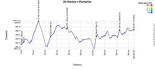

- start:
- the start will be on Avenue du Lac in Nantua (12.05pm)
- the actual start is on the D1084, 4.5 km from the assembly point (12:15 p.m.)
- altitude gain: 2,900 m, with 23.9 km of difficulty listed as cols and côtes:
- Col de la Croix de la Serra (3rd category) at km 24.7 - ^ 1,049 m / 12.1 km at 4.1%
- Côte de Valfin (4th category) at km 49.1 - ^ 667 m / 5.7 km at 4.2%
- Côte de Thésy (2nd category) at km 121.6 - ^ 685 m / 3.6 km at 8.9%
- Côte de Longeville (4th category) at km 160.1 - ^ 825 m / 2.5 km at 5.5%
- intermediate sprint: Route de Saint-Laurent à La Chaux du Dombief at km 72.3
- finish: Rocade Georges Pompidou (N57) in Pontarlier, at the end of a final straight line 150 m at sight / width 6.50 m
- Departments crossed: Ain (01) from km 0 to km 19.5, Jura (39) from km 23.6 to km 184.2
- main towns: Nantua, Saint-Claude, La Chaux du Dombief, Champagnole Pontarlier
21/ Sunday, July 27, 2025 - Mantes-la-Ville > Paris Champs-Elysées - 132.3 km
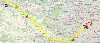
You had already been able to discover the detailed presentation of this 21st and final stage of the Tour de France 2025 with finish in Paris and the circuit to Montmartre, with an explanation of the history of the stage and the 50 years of the finish on the Champs-Elysées as well as a detailed description of the route of this stage. Its route is precisely a clever mix between the historic circuit of the last stage of the Tour de France to the Champs-Elysées and the main elements of the course of the Paris 2024 Olympic Games. More precisely, this stage will start from Mantes-la-Ville and head directly east/south-east. 61.6 kilometers separate the riders from the first crossing of the finish line, and it's this sixty kilometers or so that will be used for a little parade, champagne glass in hand for the winner and his team-mates, and this will be notably between the two climbs that are on this route. Very soon after the start, they'll climb the Côte de Bazemont, whose summit will be reached after just 10 kilometers from the actual start of this stage. The route then continues south-eastwards to Saint-Cyr-l'Ecole, where an easterly section will follow, passing the Château de Versailles and on to Viroflay, where the northeasterly ascent towards Paris will begin. After passing through Chaville, they turn onto the Côte du Pavé des Gardes. Arriving in Paris, the riders make the usual circuit 3 times along the banks of the Seine, through the small tunnel to Rue de Rivoli, then Place de la Concorde and the Champs-Elysées, before forking right to turn around the Madeleine and head for Montmartre, where they'll have to climb the Côte de la Butte Montmartre before returning to the Madeleine, Place de la Concorde and the Champs-Elysées, and repeating the usual circuit up to the point where they turn right onto Rue de Rivoli. They then do the same circuit twice more before finally finishing on the Champs-Elysées in Paris for this very last stage of the Tour de France 2025.
Below you'll find the time itinerary, profile and OpenStreetMap of the twenty-first stage of the Tour de France 2025. Click on images to enlarge.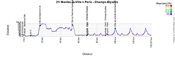

- start:
- the start will be on Rue du 8 Mai 1945 in Mantes-la-Ville (4.10pm)
- the actual start is on the D146 in Issou, 7.7 km from the assembly point (4:25 p.m.)
- altitude gain: 1,100 m, with 5.7 km of difficulty listed as passes and climbs:
- Côte de Bazemont (4th category) at km 10 - ^ 160 m / 1.7 km at 7% gradient
- Côte du Pavé des Gardes (4th category) at km 45.9 - ^ 180 m / 700 m at 9.7%
- Côte de la Butte Montmartre (4th category) three times, at km 92.7, km 109.5 and km 126.2 - ^ 128 m / 1.1 km at 5.9%
- intermediate sprint: Avenue des Champs-Elysées in Paris at km 75.9 (top of Champs-Elysées)
- finish: Champs-Elysées, Paris, at the end of a 700 m / 8 m wide final straight line
- departments crossed: Yvelines (78) from km 0 to km 43.1, Hauts-de-Seine (92) from km 43.8 to km 51.7, Paris (75) from km 51.7 to km 132.3
- main towns: Mantes-la-Ville, Épône, Villepreux, Fontenay-le-Fleury, Saint-Cyr-l'École, Versailles, Viroflay, Chaville, Meudon, Issy-les-Moulineaux, Paris
Immerse yourself in the Tour de France 2025 route maps with the velowire app!
For several weeks now, maps of all the stages have been available on the velowire mobile app (in the Maps section)! From now on, this will be the case systematically, as it's easier to publish the maps as they come in than on the website. In the velowire app, which can be used on mobile or tablet, you'll also have the opportunity to be totally immersed, with the option of making the map full-screen (by pressing the icon at the top right of the map) and displaying your geolocation on it. You can also activate the "geolocation tracking" mode (by pressing the appropriate icon in the top left-hand corner of the map) to help you find your way to the stage course as easily as possible! It's never been easier to find out exactly where the race is taking place.
NEW: the application is now available on Android and iOS!- on Android - it's easy: download the app directly from the Play Store

- on iOS (iPhone/iPad) - register to get the application - once I've received your registration, I'll give you access and tell you how to download the application.

The Tour de France 2025 route in Google Earth
Would you like to take a virtual flyover over the map of one of the stages? Or would you like to see the whole route in a single view? You can, by downloading the KMZ file (a ZIPped KML file) that opens the Tour de France 2025 route in Google Earth:
>> Download the complete Tour de France 2025 route in Google Earth (KMZ file, 2.21 MB) ATTENTION: as mentioned above, you have no right to reproduce the contents of this KMZ file or any other element of the content of this publication, whether in identical or derived form. You'll find more details on the copyright page, which explains that all content published on velowire.com is protected by copyright!door Thomas Vergouwen
Vond u dit artikel interessant? Laat het uw vrienden op Facebook weten door op de buttons hieronder te klikken!
2 comments | 29434 views
this publication is published in: Tour de France | Tour de France 2025 | OpenStreetMap/Google Maps/Google Earth


 by marco1988 over