In 1892 the very first edition of Liège-Bastogne-Liège took place, which logically gives this race the nickname La Doyenne (the oldest one). That was 125 years ago and this year we'll see the 103rd edition of the Belgian classic which will take place between Liège, Bastogne and ... Ans (finish location of the race since 1992). You can always read the history of Liège-Bastogne-Liège which I published in the article about the race route of the 100th edition in 2014.
The race route has been modified quite a bit in 2017, especially due to roadworks which prevent the race to go through Stavelot.
In this article you'll find all the details of the Liège-Bastogne-Liège 2017 race route with the road map on Google Maps/Google Earth, the profile of the race and the time- and route schedule.
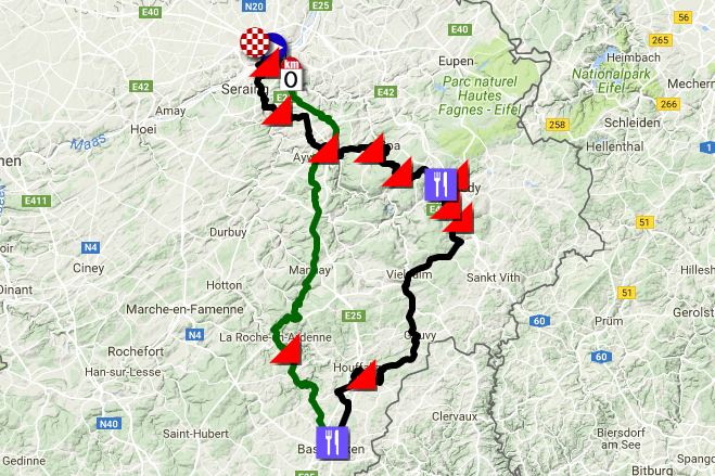
The Liège-Bastogne-Liège 2017 race route on Google Maps
This year, the race route is a bit different from usual, especially because of the roadworks which prevent the race from going through Stavelot and which thus wipes away the Côte de Wanne and the Côte de la Haute Levée from the race route, just like the Côte de Stockeu which was already removed from the race route last year. Instead, we'll see the côtes de Pont, Bellevaux and de la Ferme Libert.In the final part of the race, A.S.O. added a 600 meters long climb, with cobble stones, at 10.5%, the Côte de la Rue Naniot in Liège, last year but this year it's no longer part of the race. Therefore, the last climb will be the Côte de Saint-Nicolas at 5.5 kilometers of the finish in Ans.
After the start from the Place Saint-Lambert in Liège at 10.10AM (the advertising caravan will leave at 9.10AM), the real start will be on the N30 around 10.25AM.
The first climb will be at 70 kilometers from the start: the Côte de La Roche-en-Ardenne (2.8 km at 6.2%).
After the visit of Bastogne on the "Rond-point La Doyenne" (this roundabout is dedicated to "La Doyenne" all year long), the feeding zone will follow before the different climbs which are Côte de Saint-Roch (1 km @ 11.2%) and quite a bit further the Côte de Pont at 90 km from the finish (1 km @ 10.5%), the Côte de Bellevaux (1.1 km @ 6.8%) only 4 kilometers further and the Côte de la Ferme Libert (1.2 km @ 12.1%) another 8 km further.
After the second feeding zone in Burnenville, the riders will climb the usual Col du Rosier (4.4 km @ 5.9%), Col du Maquisard (2.5 km @ 5%), the Côte de la Redoute at 35.5 km from the finish (2 km @ 8.9%), the Côte de la Roche-aux-Faucons (1.3 km @ 11%) and the Côte de Saint-Nicolas (1.2 km @ 8.6%). The finish will, as usual, be in the Rue Jean-Jaurès in Ans, 5.5 kilometers further.
The finish is planned between 4.33PM and 5.12PM.
The Liège-Bastogne-Liège 2017 race route on Google Maps, the profile and the time- and route schedule
Hereunder you'll find the race route on Google Maps, the profile and the time- and route schedule of Liège-Bastogne-Liège 2017. In order to make the map easier to read, the Liège > Bastogne part is shown in green and the Bastogne > Ans part in black. Click on the images to open them:


CONTINUE READING AFTER THIS ADVERTISEMENT
The Liège-Bastogne-Liège 2017 race route in Google Earth
Do you prefer to see the race route in Google Earth and thus for example to a virtual fly-over of the race route? Download the KML file below to do so:> Download the Liège-Bastogne-Liège 2017 race route in Google Earth

Vond u dit artikel interessant? Laat het uw vrienden op Facebook weten door op de buttons hieronder te klikken!
5 comments | 20487 views
this publication is published in: Classics | OpenStreetMap/Google Maps/Google Earth


 by marco1988 over
bonjour, je souhaiterai savoir vers quelle heure la caravane publicitaire passera t elle dans le bas d'Ougrée?? car je voudrais y aller avec mon fils et je n'arrive pas à voir sur le net..
Merci à vous
Dank! Handige en kleurrijke informatie om deze klassieker te volgen
Bonjour @Maes #1, les horaires de la caravane sont également signalées dans l'itinéraire horaire publié dans cet article. Vous y trouverez donc toutes les informations que vous cherchez.
J'espère que vous y passerez un bon moment ! :)
Hoi @elli #2, bedankt voor de positieve reactie :-)
la caravane publicitaire passe elle a vielsalm merci
@demeuldre #4, comme indiqué dans ma réponse juste au-dessus, les horaires de la caravane sont également indiquées dans l'itinéraire horaire publié dans cet article. N'hésitez donc pas à vous y reférez !