The last Italian UCI WorldTour race of the year, Il Lombardia - the official name for the Tour of Lombardy 2025, takes place this Saturday, over a distance of 241 kilometers, between Como and Bergamo.
The Italian Fallen Leaves Classic is part of a string of Italian classics, the latest of which were won this week: the Coppa Bernocchi by Dorian Godon (Decathlon AG2R La Mondiale Team), the Tre Valli Varesine by Tadej Pogačar (UAE Team Emirates) and this Thursday's Gran Piemonte by Isaac Del Toro (UAE Team Emirates).
And Tadej Pogačar is undoubtedly already thinking about the Giro di Lombardia, as the Slovenian rider has won the last 4 editions and could make the 2025 edition his quintet of victories! In agreement with its organizer, the race will take place without the Israel Premier Tech team, which is keeping a low profile while awaiting a change of identity and nationality early 2026 ... Below you'll find all the information on the Il Lombardia / Tour of Lombardy 2025 route, with an OpenStreetMap map, the time schedule, the profile and the map in Google Earth.
CONTINUE READING AFTER THIS ADVERTISEMENT
Early availability of the route in the velowire app!
As usual, and as will always be the case from now on, this route was early available in the velowire app! In the same way, you'll find the Paris-Tours route there very soon, and before it'll be published here on the site. The app remains in test mode for the time being, but it's already available for any Android or iOS smartphone or tablet in a fully functional version.- on Android - installing is easy: download the app directly from the Play Store

- on iOS (iPhone/iPad) - follow these two steps to get the app.

The Tour of Lombardy 2025 route on an OpenStreetMap map
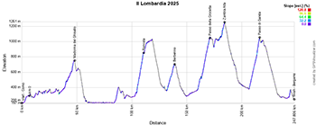
At 10:40 am on Saturday, the race starts from Como on the southern side of Lake Como, heading first for Cantù, then up to Bellagio at the fork of the inverted Y formed by Lake Como. By then, the riders will already have climbed the first of the day's 6 difficulties, the Madonna del Ghisallo (^ 755 m), before following the other branch of the Y to Lecco and beyond to Ciasano Bergamasco.They then traverse eastwards before going up again, via the Roncola ascent (^ 855 m, 9.4 km at 6.6%, but up to 17% at the start of the climb!). The difficulties then follow one after the other, with the climb to BerbennoPasso della Crocetta (^ 1051 m, 11 km at 6.2%, with a maximum of 11%) and the climb to Zambla Alta (^ 1257 m, 9.5 km at 3.5%, with a maximum of 10%). Shortly after the latter, they enter the final branch of the course, heading for the finish, where they will find the climb to the Passo di Ganda (^ 1058 m, 9.2 km at 7.3%, with a maximum of 15% at the end of the climb). The Passo di Ganda has a descent of 19 hairpin bends after Selvino, and at the bottom of the descent there are 9 km on the flat... before the last 5 km start again with a small climb, bearing in mind that the last 3 km to the finish in Bergamo are downhill to via Roma, where the winner of this 119th edition of the Giro di Lombardia will be known.
Below you'll find the time schedule, profile and OpenStreetMap map of the Giro di Lombardia 2025 route. Click on images to enlarge.


CONTINUE READING AFTER THIS ADVERTISEMENT
The Giro di Lombardia 2025 route in Google Earth
Would you like to see the Tour of Lombardy 2025 route in Google Earth, so you can take a virtual flyover over the course of this Italian classic? Download the KML file below and open it in Google Earth to do so.>> Download the Giro di Lombardia 2025 route in Google Earthdoor Thomas Vergouwen
Vond u dit artikel interessant? Laat het uw vrienden op Facebook weten door op de buttons hieronder te klikken!
no comments yet | 3035 views
this publication is published in: Il Lombardia | OpenStreetMap/Google Maps/Google Earth


 by marco1988 over