Tomorrow, on Saturday 11 May 2019, the Giro d'Italia 2019 will start in Bologna with an individual time trial. The 102th edition of the Tour of Italy, which celebrates in 2019 its 110th anniversary, is made up of 21 stages of which three will be individual time trials (the 1st, 9th and 21st stage) for a total distance of 3,576.8 kilometers. 7 stages will have a mountain top finish while 5 stages will take place in the higher mountains and 7 in the medium mountains.
Let's now look in detail all stages of this Tour of Italy 2019 with the maps on Open Street Maps/Google Earth.
The Giro d'Italia 2019 race route on Open Street Maps
CONTINUE READING AFTER THIS ADVERTISEMENT
1/ Saturday 11 May 2019 - Bologna > Bologna - individual time trial - 8 kmThe first stage of this Tour of Italy 2019 is a timed races in the streets of the city Bologna. After a start in the city centre, the riders will go to the extreme south of the city where an intermediate timing point will be placed at the foot of the final climb towards the Madonna di San Luca.
The first rider to start in this individual time trial will be Tom Dumoulin (Team Sunweb) at 4.50PM and the rider who will finish off this time trial is Salvatore Puccio (Team Ineos) who will start at 7.45PM.
You'll find hereunder the start order and -times for this initial time trial of the Tour of Italy 2019:
>> start order and -times of the first stage of the Giro d'Italia 2019: time trial in Bologna
Hereunder you'll find the time- and route schedule, the stage profile and the race route on Open Street Maps of the 1st stage of the Giro d'Italia 2019. Click on the images to open them.


2/ Sunday 12 May 2019 - Bologna > Fucecchio - 205 km
The second stage of this Tour of Italy will start almost at the same place as the time trial the day before, in the centre of Bologna, but this time a stage in line of no less than 205 kilometers awaits the riders. A first climb after about fifty kilometers in the stage is not referenced for the King of the Mountains classification. Therefore, it's only in the second part of the stage that we'll find the two intermediate sprints, in Montespertoli, on top of a short climb, and in Empoli. Two climbs will remain at that time, Montalbano (il Castra) and San Baronto, respectively of the 3rd and 4th category, but the sprinters teams will most probably be able to get organised for the finish in Fucecchio to allow one of them to win this second stage.
Hereunder you'll find the time- and route schedule, the stage profile and the race route on Open Street Maps of the 2nd stage of the Giro d'Italia 2019. Click on the images to open them.


3/ Monday 13 May 2019 - Vinci > Orbetello - 220 km
From Vinci, at the same level as Florence, the riders will start the 3rd stage, via Emboli, and like the previous stage again via a climb which is not referenced for the KOM classification, via Certaldo and the intermediate sprint in Poggibonsi, the sprint in Grosseto and the climb of the Poggio l'Apparita of the 4th category, followed by about 25 kilometers flat towards the finish line in Orbetello, mostly on the coastal road around the laguna of Ponente.
Hereunder you'll find the time- and route schedule, the stage profile and the race route on Open Street Maps of the 3rd stage of the Giro d'Italia 2019. Click on the images to open them.


4/ Tuesday 14 May 2019 - Orbetello > Frascati - 235 km
Starting in Orbetello, almost at the same place as the finish the day before, a 235 kilometers long stage awaits the riders, first going landinwards up to the Bolsena lake via the climb of Manciano (4th category), and then direction south-east, via the intermediate sprint in Vetralla just after the feeding zone. North-east of Rome the riders will battle for the sprint in Mentana, before they go on till the finish in Frascati.
Hereunder you'll find the time- and route schedule, the stage profile and the race route on Open Street Maps of the 4th stage of the Giro d'Italia 2019. Click on the images to open them.


CONTINUE READING AFTER THIS ADVERTISEMENT
5/ Wednesday 15 May 2019 - Frascati > Terracina - 140 km
The 5th stage will be a shorter stage, starting in Frascati, and after a short detour via Rocca Priora and a slightly hilly early part of the stage, the riders will find the two intermediate sprints of this stage quite close to each other, in Cisterna di Latina and in Latina, before the only climb of the day in Sezze (4th category). What remains is the descent and a flat part of about 40 kilometers, towards the finish line in Terracina, after one lap on a circuit around the finish city.
Hereunder you'll find the time- and route schedule, the stage profile and the race route on Open Street Maps of the 5th stage of the Giro d'Italia 2019. Click on the images to open them.


6/ Thursday 16 May 2019 - Cassino > San Giovanni Rotondo - 238 km
It's almost the longest stage of this Giro d'Italia 2019, except for one kilometer, which awaits the riders at the start in Cassino this Thursday 16 May. This stage will allow the race to cross the country from west to east. Despite the climbs one can see on the stage profile, it's only in the final part of this stage that we'll find a real climb, the Coppa Casarinelle of the 2nd category, almost immediately followed by the intermediate sprint in San Marco in Lamis. Once the riders get in the finish city San Giovanni Rotondo, they'll do almost a complete loop before they cross the white line in the via Aldo Moro.
Hereunder you'll find the time- and route schedule, the stage profile and the race route on Open Street Maps of the 6th stage of the Giro d'Italia 2019. Click on the images to open them.


7/ Friday 17 May 2019 - Vasto > L'Aquila - 185 km
After a transfer to the start in Vasto, this stage will first follow the coast line, up to the sprint in Ortona, before it goes landinwards, via the sprint in Ripa Teatina and via Chieti. At about fifty kilometers from the finish, the riders will have a 2nd category difficulty to climb, Le Svolte di Popoli. After that, they'll turn north-west, towards the finish in L'Aquila, after a tour around the castle which dominates the city.
Hereunder you'll find the time- and route schedule, the stage profile and the race route on Open Street Maps of the 7th stage of the Giro d'Italia 2019. Click on the images to open them.


8/ Saturday 18 May 2019 - Tortoreto Lido > Pesaro - 239 km
A transfer allows the riders to get back on the sea side where they'll start the 8th stage of the Giro d'Italia 2019 in Tortoreto Lido. They'll follow the coast line via Ancona, the feeding zone of the stage, the sprint in Senigallia and up to Mondolfo where they'll turn left, to get to the sprint in Calcinelli. Immediately after that, they'll climb the Monte della Mattera of the 3rd category and while going towards the finish city of Pesaro doing a detour via Cattolica, they'll climb two other difficulties of the 4th category, Monteluro and Gabicce Monte.
Hereunder you'll find the time- and route schedule, the stage profile and the race route on Open Street Maps of the 8th stage of the Giro d'Italia 2019. Click on the images to open them.


CONTINUE READING AFTER THIS ADVERTISEMENT
9/ Sunday 19 May 2019 - Riccione > San Marino (RSM) - individual time trial - 34.8 km
The first week of the Giro d'Italia 2019 ends with the 9th stage which is an individual time trial, similar (but much longer) to the one which kicked off this Tour of Italy, ending up in a climb.
The start will be in Riccione in Italy, but the riders will go off towards the Repubblica di San Marino, and climb towards the finish in San Marino.
Hereunder you'll find the time- and route schedule, the stage profile and the race route on Open Street Maps of the 9th stage of the Giro d'Italia 2019. Click on the images to open them.


R1/ Monday 20 May 2019
After a long week of 9 stages, the riders can get some rest on this Monday 20 May.10/ Tuesday 21 May 2019 - Ravenna > Modena - 145 km
The day after the first rest day, the Giro d'Italia 2019 gets off again in a quite quiet way, with a completely flat stage, between Ravenna and Modena. While the stage victory will thus most probably be decided in a bunch sprint, the riders will battle for two intermediate sprints, in San Giovanni in Persiceto and in Crevalcore.
Hereunder you'll find the time- and route schedule, the stage profile and the race route on Open Street Maps of the 10th stage of the Giro d'Italia 2019. Click on the images to open them.

11/ Wednesday 22 May 2019 - Carpi > Novi Ligure - 221 km
The 11th stage will again be a flat stage, this time over a longer distance, of 221 kilometers, to continue the way from east to west in the country. The start will be in Carpi and the riders will go towards Novi Ligure, following in the final part of the stage a bit of the Milan-Sanremo race route. The victory at the finish of the stage will most probably again be decided in a bunch sprint, especially because the final straight line will this time be no less than 2.8 kilometers long. Before they get there, the riders will battle for two intermediate sprints, in San Zenone Al Po and in Pontecurone.
Hereunder you'll find the time- and route schedule, the stage profile and the race route on Open Street Maps of the 11th stage of the Giro d'Italia 2019. Click on the images to open them.


CONTINUE READING AFTER THIS ADVERTISEMENT
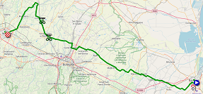
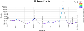
12/ Thursday 23 May 2019 - Cuneo > Pinerolo - 158 km
For the start of the 12th stage, the riders will have had a transfer towards Cuneo and the stage which awaits them will be relatively short but certainly not easy. It will be slightly hilly all way long and contains the first climb of the 1st category of this Giro d'Italia 2019, the Montoso which offers an average slope of 9.4% over 8.9 km and going up to 14% at some points. After a rapid descent, the finish city Pinerolo will be at only 16 kilometers, which thus might offer an opportunity to a breakaway rider to win the stage and maybe even for the general classification riders to gain some time on their competitors.
Hereunder you'll find the time- and route schedule, the stage profile and the race route on Open Street Maps of the 12th stage of the Giro d'Italia 2019. Click on the images to open them.

13/ Friday 24 May 2019 - Pinerolo > Ceresole Reale (Lago Serù) - 196 km
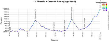
The start of the 13th stage will take place in Pinerolo, where the previous stage had its finish. It will be a real mountain stage because not only the riders will, while turning around Turin, climb the Colle del Lys of the 1st category and the Pian del Luppo of the 2nd category, the stage will also end with a long climb towards the finish above Ceresole Reale, at the Lago Serrù, a 1st category climb.
Hereunder you'll find the time- and route schedule, the stage profile and the race route on Open Street Maps of the 13th stage of the Giro d'Italia 2019. Click on the images to open them.

14/ Saturday 25 May 2019 - Saint Vincent > Courmayeur - 131 km
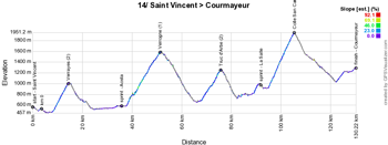
For the start of the 14th stage, a transfer will have been necessary, to get to Saint Vincent and the stage awaiting the riders this Saturday will be short but difficult. During this stage, the riders will have to climb no less than 4 difficulties (not taking into account the intermediate sprint which will be in La Salle on top of a short climb as well): Verrayes (2nd category), Verrogne (1st category), Truc d'Arbe (2nd category) and Colle San Carlo (1st category), before they end of the stage with a final climb towards the finish at Courmayeur where the finish line will be drawn at the cableway Skyway Monte Bianco which connects Courmayeur to the Mont Blanc and Chamonix. This final climb will be 8 kilometers long with an average slope of 6% for the first 3 kilometers and then 2 to 3% for the remaining distance.
Hereunder you'll find the time- and route schedule, the stage profile and the race route on Open Street Maps of the 14th stage of the Giro d'Italia 2019. Click on the images to open them.

15/ Sunday 26 May 2019 - Ivrea > Como - 232 km
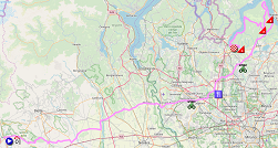
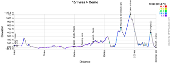
From the border with France, the riders will have had a transfer to Ivrea for the start of the 15th stage which will, with its 232 kilometers, be longer than the previous stages. Even though it's a middle mountain stage, the first 160 kilometers will be on flat roads, via the intermediate sprints in Busto Arsizio and in Cantù. In the final part things get more difficult, with the famous Madonna del Ghisallo with slopes going up to 14%, rapidly followed by the climb of the Colma di Sormano and after a first visit of the city of Como, another climb awaits and it'll be at less than 9 kilometers from the finish that the riders will reach the top in Civiglio, after which they'll descend towards the finish in Como.
Hereunder you'll find the time- and route schedule, the stage profile and the race route on Open Street Maps of the 15th stage of the Giro d'Italia 2019. Click on the images to open them.
CONTINUE READING AFTER THIS ADVERTISEMENT
R2/ Monday 27 May 2019
After the second week of racing in this Tour of Italy 2019, the riders will again be able to get some rest on this Monday 27 May.
What follows in this article has unfortunately not been translated from French to English. This content is provided in this article anyway since it allows you to discover the following stages. At the end of this article you'll also find the race routes in Google Earth.16/ mardi 28 mai 2019 - Lovere > Ponte di Legno - 226 km
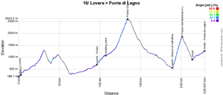
Au bord du lac à Lovere c'est une longue étape alpestre qui attend les coureurs du Giro d'Italia 2019. D'abord ils passeront par deux montées non référencées, le Passo della Presolana et le Passo della Croce di Salven. Après le sprint d'Edolo, ils arrivent alors sur le circuit final de l'étape et après la zone de ravitaillement ils passeront une première fois sur la ligne d'arrivée à Ponte di Legno. C'est depuis l'entrée sur le circuit qu'ils se trouvent alors sur des routes en pente mais après ce premier passage sur la ligne ils entament la vraie montée du fameux Passo Gavia, avec ses 2618 mètres le toit de ce Tour d'Italie 2019. La descente les mène alors par Bormio où ils tournent vers le sud jusqu'au sprint à Mazzo di Valtellina où s'arrête la descente puisqu'ils seront alors au pied de la dernière montée de l'étape, le Passo del Mortirolo de 1ère catégorie. Sa descente continue ensuite jusqu'au point d'entrée sur le circuit à Monno et il reste alors une quinzaine de kilomètres en légère montée (3 à 4%) jusqu'à l'arrivée à Ponte di Legno !
Ci-dessous vous trouverez l'itinéraire horaire, le profil et la carte Open Street Maps du parcours de la 16ème étape du Giro d'Italia 2019. Cliquez sur les images pour les agrandir.

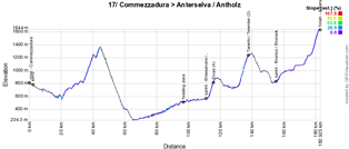
17/ mercredi 29 mai 2019 - Commezzadura (Val di Sole) > Anterselva/Antholz - 181 km
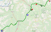
La 17ème étape commence en descente à Commezzadura (Val di Sole) jusqu'à Fondo, d'où les coureurs entament la montée du Passo della Mendola qui n'est pas référencée pour le classement de meilleur grimpeur mais qui ne s'en sentira pas moins dans les jambes en ce début d'étape. Après la descente de cette difficulté jusqu'à Bolzano/Bozen, la suite de l'étape sera quasiment en montée continue, avec une pente plus ou moins importante, mais les difficultés seront moins importantes que sur les étapes précédentes.
En effet, après le sprint de Bressanone/Brixen, ils auront une difficulté de 4ème catégorie à monter, jusqu'à Elvas alors qu'un peu plus tard ils monteront vers Terento/Terenten. Après une courte descente, ils se disputent alors un sprint intermédiaire à Brunico/Bruneck où un départ d'étape du Tour d'Italie avait eu lieu en 2010. A partir de là ils monteront progressivement vers le pied de la montée finale d'Anterselva/Antholz. L'arrivée n'aura pas lieu dans le village principal mais juste avant le lac qui porte le même nom, dans le centre de biathlon, après le passage dans un tunnel pour y accéder.
Ci-dessous vous trouverez l'itinéraire horaire, le profil et la carte Open Street Maps du parcours de la 17ème étape du Giro d'Italia 2019. Cliquez sur les images pour les agrandir.
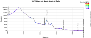
18/ jeudi 30 mai 2019 - Valdaora/Olang > Santa Maria di Sala - 222 km
La 18ème étape se déroule majoritairement en descente au départ de Valdaora/Olang. La seule difficulté référencée se trouve au milieu de l'étape, à Pieve di Alpago (4ème catégorie) et les deux sprints intermédiaires se trouvent dans la deuxième partie de l'étape, à Conegliano et à Scorzè à seulement 17 kilomètres de l'arrivée à Santa Maria di Sala.
Ci-dessous vous trouverez l'itinéraire horaire, le profil et la carte Open Street Maps du parcours de la 18ème étape du Giro d'Italia 2019. Cliquez sur les images pour les agrandir.

CONTINUE READING AFTER THIS ADVERTISEMENT
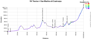
19/ vendredi 31 mai 2019 - Treviso > San Martino di Castrozza - 151 km
Pour la 19ème étape au départ de Treviso, c'est une étape relativement courte et vallonnée qui attend les coureurs. Au cours de l'étape, ils ne trouveront que le Passo di San Boldo de 3ème catégorie et la montée de Lamon de 4ème catégorie, ainsi que les deux sprints intermédiaires, à Lentiai et à Fonzaso. La montée finale se déroule alors encore sur une petite quinzaine de kilomètre, pour une montée de deuxième catégorie, jusqu'à l'arrivée à San Martino di Castrozza.
Ci-dessous vous trouverez l'itinéraire horaire, le profil et la carte Open Street Maps du parcours de la 19ème étape du Giro d'Italia 2019. Cliquez sur les images pour les agrandir.

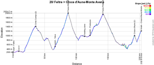
20/ samedi 1er juin 2019 - Feltre > Croce d'Aune-Monte Avena - 194 km
Le dernier week-end de ce Tour d'Italie 2019 commencera par une nouvelle étape de montagne, qui forme quasiment une boucle entre départ et arrivée, mais mesure toutefois 194 km. Rapidement après le départ de Feltre commence la montée de la Cima Campo dont le sommet sera atteint après 27,1 kilomètres. Après la descente de cette première difficulté, de 2ème catégorie, et le sprint à Telve, les coureurs commencent déjà la montée de la montée de 1ère catégorie, le Passo Manghen.
Lors du passage dans la vallée qui suit la descente de cette deuxième difficulté, les coureurs pourront se ravitailler avant de se disputer le deuxième sprint intermédiaire à Predazzo et enchaîner sur la troisième montée du jour, celle du Passo Rolle. Après une longue descente, il restera alors l'enchaînement des deux dernières difficultés, dont l'arrivée en altitude. Cet enchaînement commence par une montée de deuxième catégorie, celle du Croce d'Aune. Après une courte descente, les coureurs attaquent alors une montée pentue de 7 km à 7,4% (montant par endroit jusqu'à 10%) qui lui doit la classification en première catégorie !
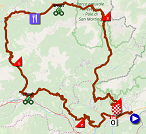
Ci-dessous vous trouverez l'itinéraire horaire, le profil et la carte Open Street Maps du parcours de la 20ème étape du Giro d'Italia 2019. Cliquez sur les images pour les agrandir.
21/ dimanche 2 juin 2019 - Verona > Verona - contre-la-montre individuel - 17 km
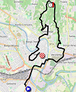
La toute dernière étape du Tour d'Italie 2019 se déroulera sous forme de contre-la-montre d'une longueur de 17 kilomètres dans la ville de Verona. La première partie se déroule sur le plat, pour ensuite enchaîner sur une montée d'environ 4,5 km au milieu de l'étape, avant une fin à nouveau sur le plat.
Ci-dessous vous trouverez l'itinéraire horaire, le profil et la carte Open Street Maps du parcours de la 21ème étape du Giro d'Italia 2019. Cliquez sur les images pour les agrandir.

The Tour of Italy 2019 race route in Google Earth
You have just discovered the race route of the Giro d'Italia 2019 stages on Open Street Maps, as well as their stage profile and time- and route schedule. If you'd like to see the Tour of Italy 2019 race route as a whole or if you'd like to do a virtual fly-over of one of the stages for example, you'll find a link below which allows you to download the Giro d'Italia 2019 race route in Google Earth, thanks to a KML file which allows you to open it in Google Earth ! :
>> Download the Giro d'Italia 2019 race route in Google Earth

Vond u dit artikel interessant? Laat het uw vrienden op Facebook weten door op de buttons hieronder te klikken!
4 comments | 13462 views
this publication is published in: Giro d Italia | Giro d'Italia 2019 | OpenStreetMap/Google Maps/Google Earth


CONTINUE READING AFTER THIS ADVERTISEMENT


CONTINUE READING AFTER THIS ADVERTISEMENT


CONTINUE READING AFTER THIS ADVERTISEMENT


CONTINUE READING AFTER THIS ADVERTISEMENT


CONTINUE READING AFTER THIS ADVERTISEMENT


 by marco1988 over
Stage 16 has been modified due to avalanches risk along Passo Gavia
The new trak in 195km long with a new climb: Cevo, category 3.
https://riders.dalli.it/races/GDI/2019/kml/16.kml
Ciao Stefano, can you share also the next stages kml please?
Thomas didn't share it yet unfortunately..
thank you both!
Andrea
ok Stefano, I made it changing the end number of the path..
thanks a lot, Andrea
The KML file of the whole race route has now been published. The KML files for the individual stages were of course available as well through some retro engineering ;-).
As for today's stage, I did see the change of course but didn't have the time to integrate it. It also reminded me of the bad memories of a few years ago where I corrected a stage based on a new race route .. for the stage being cancelled in the end! ;-)