Saturday 05 October 2013 at 16h47
Now the World Championships in Italy are over, the UCI WorldTour comes back in sight tomorrow (Sunday), with Il Lombardia or the Tour of Lombardy 2013, the day before the presentation of the Giro d'Italia 2014 race route.
Il Lombardia, 107th edition, will -like last year- follow a new race route this year, but conserves the start from Bergamo and the finish in Lecco. Hereunder you'll discover the new race route on Google Maps/Google Earth, the time- and route schedule and the profile.
The race of the falling leaves will take place tomorrow, awaiting its little brother Paris-Tours in France next week.
CONTINUE READING AFTER THIS ADVERTISEMENT
The description of the Tour of Lombardy 2013 race route
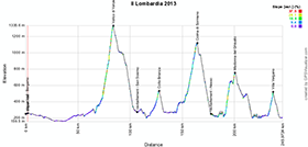
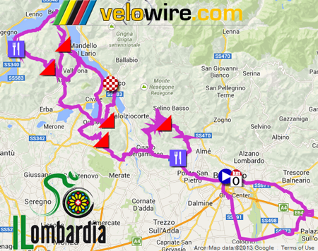
After the start in Bergamo, the riders will go east and find kilometer 0 at the ring around the city for a loop via Grumello del Monte and coming back close to the start from where they'll go towards Ponte San Pietro and turn right on the SP177 towards the climb of Valico di Valcava and its 1336 meters altitude (at that time they've returned back on the same race route as last year). After the descent they'll get to the feeding zone of San Sosimo and will cross the race route they've followed before, in Cisano Bergamasco. This climb is 11.7 kilometers long with an average steepness of 8% (height difference of 934 meters) which will get to its highest in the second third of the climb, with 17%.At Colle Brianza, they climb again, up to 533 meters of altitude. After the descent they get in the feeding zone, before they attack a new climb which has it's top in Sormano (Colma di Sormano) at an altitude of 1124 meters. This climb is 9.48 km long and has an average steepness of 6.6% (height difference of 629 meters and a maximum steepness of 12%). After the descent of this climb and after a ride alongside the Como Lake (Lago di Como), they'll climb the usual Madonna del Ghisallo (754 meters) where they'll see the mythical chapel of the patroness of cyclists. This climb is 8.58 km long for a height difference of 532 meters and an average steepness of 6.2% (maximum steepness of 14% early in the climb).
A few flat kilometers follow the descent before the riders attack the last climb in Villa Vergano (Salita di Ello, 522 meters of altitude for a height difference of 243 meters and an average steepness of 7.4% [maximum steepness of 15% towards the end of the climb]) of which the top will be at 9 kilometers from the finish line which will be drawn for the third time in the Lungo Lario Isonzo in Lecco.
The Tour of Lombardy 2013 race route on Google Maps, the time- and route schedule and the profile of the race
Thanks to a little bit of help from Gerard Willems, you'll find below the race route of the Tour of Lombardy 2013 on Google Maps, its profile and the time- and route schedule. Click on the images to open them:


CONTINUE READING AFTER THIS ADVERTISEMENT
The Tour of Lombardy 2013 race route in Google Earth
Would you like to do a virtual fly-over of this race route? Or do you simply prefer to view it in Google Earth?>> Click here to download the Tour of Lombardy 2013 race route in Google Earth (KML file)

Vond u dit artikel interessant? Laat het uw vrienden op Facebook weten door op de buttons hieronder te klikken!
no comments yet | 11100 views
this publication is published in: Il Lombardia | OpenStreetMap/Google Maps/Google Earth


 by marco1988 over