Friday 14 October 2011 at 09h20
This Saturday, the 15th of October 2011, one of the very last races of the 2011 season of the UCI cycling calendar, the Tour of Lombardy 2011, will take place.
Il Lombardia will have a new race route this year, still starting in Milan but this time going towards Lecco and without doing the tour around the Como Lake. I think it was therefore about time to present you the Google Maps/Google Earth map of this race course, together with the time and route schedule and the race profile.
Will this race route still please a rider like Philippe Gilbert (Omega Pharma-Lotto) who won the 2 previous editions?
The description of the Tour of Lombardy 2011 race route
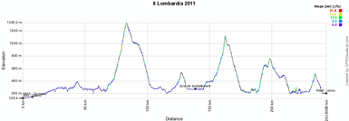
After the start from Milan, the riders will go north to the real start in Cormano. From there, they'll continue north towards Como up to Copreno where they'll continue their road eastwards to do a loop including the climb of Valcava (Valico di Ca'Perrucchini) and its 1340 meters of altitude before the descent and a crossing of the same road they used to go find this climb at Cisano Bergamasco. This climb is 11.7 kilometers long with an average steepness of 8% (height difference of 934 meters) which will get to its highest in the second third of the climb, with 17%.At Colle Brianza, they climb again, up to 533 meters of altitude. After the descent they get in the feeding zone, before they attack a new climb which has it's top in Sormano (Colma di Sormano) at an altitude of 1124 meters.
A few flat kilometers follow the descent before the riders attack the last climb in Villa Vergano (Salita di Ello, 522 meters of altitude for a height difference of 243 meters and an average steepness of 7.4% [maximum steepness of 15% towards the end of the climb]) of which the top will be at 9 kilometers from the finish line which will be drawn for the very first time in the Lungo Lario Isonzo in Lecco.
The Tour of Lombardy 2011 race route on Google Maps, the time and route schedule and the race profile
Hereunder, you'll find the Google Maps version of the Tour of Lombardy 2011 race route, its profile and the time and route schedule. Click on each of the images to open them:


CONTINUE READING AFTER THIS ADVERTISEMENT
The Tour of Lombardy 2011 race route in Google Earth
Would you like to do a virtual fly-over of this race route? Or do you simply prefer to view it in Google Earth?>> Click here to download the Tour of Lombardy 2011 race route in Google Earth (KML file)
The promotion video of Il Lombardia 2011
Vond u dit artikel interessant? Laat het uw vrienden op Facebook weten door op de buttons hieronder te klikken!
no comments yet | 7567 views
this publication is published in: OpenStreetMap/Google Maps/Google Earth | Il Lombardia | Classics


 by marco1988 over