Saturday 24 April 2010 at 13h32
Liège-Bastogne-Liège was won last year by Andy Schleck and is again on the programme for tomorrow, with a slightly modified route!
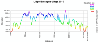
Will Alejandro Valverde be able to offer himself a nice birthday present by winning this Belgian classic, nicknamed La Doyenne (because it's the oldest classic), for the 3rd time (after 2006 and 2008)? We'll only know that by the end of the afternoon tomorrow, but you can right now discover the Liège-Bastogne-Liège 2010 route, on Google Maps, with the profile of the race and its time and route schedule!
The Liège-Bastogne-Liège 2010 route
The Liège-Bastogne-Liège route will be a little bit different for this 96th edition because the Côte de Haute-Levée could no longer be part of the race because of the condition the road is in.This climb and the Côte de Vecquée have thus been replaced by the Col du Maquisard (at 59 km from the finish) and Mont-Theux (at 49 km from the finish). Since these climbs are closer to the finish, the final part of La Doyenne is now even harder!
After the start from the Place Saint-Lambert in Liège at 10AM (the advertising caravan will leave at 8.45AM), the real start will be on the N30 at 10.15AM. The first climb is 69 kilometers further: the Côte de la Roche-en-Ardenne.
After the U-turn on the Rond-point La Doyenne in Bastogne, the riders will arrive in the feeding zone in Luzery before starting the successive climb of the Côte de Saint Roch, the Côte de Wanne at 98 km from the finish, the Côte de Stockeu 6 km further, the Col du Rosier at 71 km from the finish, the Col du Maquisard, Mont-Theux, the Côte de la Redoute at 34 from the finish, the Côte de la Roche aux Faucons at 19 km from the finish and finally the Côte de Saint-Nicolas. 5 kilometers further, the finish line will be drawn in the Rue Jean-Jaurès in Ans.
The second feeding zone is in La Gleize at 80 kilometers from the finish.
The finish is planned between 4.24PM and 5.02PM.
CONTINUE READING AFTER THIS ADVERTISEMENT
The Liège-Bastogne-Liège 2010 route on Google Maps, the profile and the time and route schedule
Below you can find the route on Google Maps, the profile and the time and route schedule (with the times the race passes in the different cities and villages) of Liège-Bastogne-Liège 2010. Click on each of the images to open them:


The Liège-Bastogne-Liège 2010 route in Google Earth
Would you prefer to view the route in Google Earth and thus be able for example to make a virtual fly-over over it? Download the KML file below to do so:> Download the Liège-Bastogne-Liège 2010 route in Google Earth
This file will not only allow you to visualise the whole route in Google Earth but also to do a virtual fly-over over the route. To do so, you can of course use the default configuration for Google Earth, but if you would like to do a virtual fly-over as if you were riding on the roads of Liège-Bastogne-Liège 2010, I would recommend the following settings: in the menu Tools > Options choose the tab Touring and fill in the following choices on that tab:
- Camera tilt angle : 80.0 degrees
- Camera range : 150.0 meters
- Speed : 500.0 (if this makes you feel dizzy or if your computer or Internet connection don't allow you to get clear images with these settings, you can try lowering the speed) door Thomas Vergouwen
Vond u dit artikel interessant? Laat het uw vrienden op Facebook weten door op de buttons hieronder te klikken!
7 comments | 22233 views
this publication is published in: Classics | OpenStreetMap/Google Maps/Google Earth


 by marco1988 over
http://www.cyclisme-roltiss-over.com/article-le-parcours-de-liege-bastogne-liege-2010-sur-google-maps-google-earth-et-l-itineraire-horaire-49190470.html
Cette course un événement dans la région jlm
Quitte à proposer un plan google map, donnez au moins le bon, ça m'évitera à l'avernir de poireauter 30 minutes devant chez moi pour rien...
Bonjour lorkan,
Soyez plus précis : s'il y a une erreur quelque part je veux bien la corriger, mais là vous ne m'aidez pas trop !
Si il s'agit du chemin emprunté entre le départ fictif et le départ réel, je confirme qu'il peut ne pas être précis car ces informations ne sont pas disponibles sauf dans le livre de route. Comme je ne suis pas sur place, je ne l'ai pas récupéré et j'ai donc fait au mieux (tout comme à l'arrivée où a priori ça devrait être bon).
Ca concernait effectivement le trajet intra muros au départ, ils ne sont pas passés par le boulevard de l'automobile/boulevard de douai. Ils ont dû passer quai des ardennes.
Désolé pour le ton du commentaire, ce n'est pas bien grave mais j'étais juste déçu de ne pas les voir alors que je ne pouvais déjà pas aller au départ.
Thomas Mooi Werk OM telkens van Ritten op Zeer Mooi googlete Suus IK VOOR Mij daar ken van de wegen op Het Scherm naakt in de (tv) in KAN volgen op Tijd OM bin foto \ 'vanuit België te IK daar alles op Volg pct. Bedankt VOOR DE sterven moeite steekt u in de st groetjes Yvan
@Lorkan : excuses acceptées pour le ton du commentaire :-) et désolé de mon côté pour la déception ! J'essaierai par la suite de demander à A.S.O. les itinéraires horaires un peu en avance pour également connaître le parcours neutralisé entre le départ fictif et le départ réel !