Saturday 18 April 2015 at 09h39
This weekend there will not only be the Amstel Gold Race (on Sunday), but also the Tour du Finistère today and the Tro Bro Léon tomorrow!
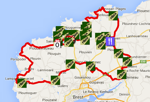
For this last mentioned race this article contains the race route on Google Maps, the time- and route schedule, the profile and the possibility to download the race route to open it in Google Earth. You'll also find a description of all the ribins ... and velowire.com will be present on this race in Brittany to share the race with you in photos and in a written summary and early next week in video!
CONTINUE READING AFTER THIS ADVERTISEMENT
The Tro Bro Léon 2015 on Google Maps
The Tro Bro Léon is some sort of a bis repetita of Paris-Roubaix. Without really comparing both races, where the second part of the Hell of the North's race route is full of cobble stones, the Tro Bro Léon - the Hell of the West - contains ribins which make this race particular.I already hear you say ribins, what's that? Well, ribins (pronounce it as reebeens) or ribinous are roads across the fields, either as a sans road but often containing some gravel, which are spread around the race route. No less than 23 different ribins are on the race route, of which one is ridden 3 times in the laps on the circuit around the finish city (to get to a total of 25 ribins), for a total distance of 31.9 kilometers (the longest ribin is 3.3 kilometers long).
The start and finish will be in Lannilis, north of Brest. From there, the riders will leave the neutralised zone on the D28 where the sea enters the land close to Saint-Pabu. Via Ploudalmézeau they go to the coast line which they follow via the touristical route before they go back landinwards via Brélès and back to the sea close to Lampaul-Plouarzel. They'll then discover the different ribins:
| # | location | length | name | km from the start |
| 01 | Plouarzel | 1.100 m | Les Eoliennes | 37,5 |
| 02 | Milizac | 1.700 m | Coatquennec | 51 |
| 03 | Bourg-Blanc | 2.200 m | Ty Douar | 60,1 |
| 04 | Plabennec | 2.300 m | Lanorven | 69,9 |
| 05 | Landerneau | 1.200 m | Kergreis | 86,5 |
| 06 | Trémaouezan | 1.100 m | Kervelec | 95,1 |
| 07 | Ploudaniel | 1.400 m | Le Guézou Braz | 102,2 |
| 08 | Lanarvily | 700 m | Salle des fêtes | 112,1 |
| 09 | Kernilis | 1.500 m | Le Clos | 114,9 |
| 10 | Le Folgoët | 1.200 m | Guiquelleau | 118 |
| 11 | Plounéour Trez | 1.200 m | Le désert | 130,4 |
| 12 | Guissény | 2.000 m | Lanveur | 151,9 |
| 13 | Plouguerneau | 1.0200 m | V Anteren | 154,8 |
| 14 | Plouguerneau | 1.500 m | Kerdelan | 157,4 |
| 15 | Plouguerneau | 800 m | Kerfaven | 159,6 |
| 16 | Plouvien | 800 m | Le Diouris | 163,4 |
| 17 | Lannilis | 1.400 m | Kerouartz | 168,7 |
| 18 | Lannilis | 900 m | Pouldu | 171,3 |
| 19 | Lannilis | 700 m | Mescoat | 174,1 |
| 20 | Lannilis | 800 m | Les Anges | 179 |
| 21 | Lannilis | 1.000 m | Ker Ar Groaz | 181,6 |
| 22 | Lannilis | 3.300 m | Mescleguer | 184,8 km |
| 23>25 | Lannilis | 700 m | Meshuel | 192 196,8 201,6 |
Hereunder you'll find the race route on Google Maps, the profile and the time- and route schedule of the Tro Bro Léon 2015. Click on the images to open them.


The Tro Bro Léon 2015 race route in Google Earth
Do you prefer to see the Tro Bro Léon 2015 race route in Google Earth and for example do a virtual fly-over of the race route? Download the following KML below:>> Download the Tro Bro Léon 2015 race route in Google Earth

Vond u dit artikel interessant? Laat het uw vrienden op Facebook weten door op de buttons hieronder te klikken!
1 comment | 14643 views
this publication is published in: OpenStreetMap/Google Maps/Google Earth | Tro Bro Léon | Coupe de France


 by marco1988 over
Tous ceux qui connaissent le secteur ne me démentiront sûrement pas : le vainqueur sera un très bon (mais aussi un chanceux)!
"P 22"