Friday 9 May 2014. Belfast, Ireland.
That doesn't ring a bell for you? You did not immediately think of the Giro d'Italia 2014, the 79th edition of the Tour of Italy? Not really surprising since this Italian Grand Tour starts for the first time from Ireland and it's start will be on a Friday instead of a Saturday as usual.
All other details about the race routes, the roads the riders will follow, the time- and route schedule/itinerary, the stage profiles and the tracks on Google Maps/Google Earth can be found in this article, in order to follow the fight for pink in the best possible way!
The Giro d'Italia 2014 race route on Google Maps
The start from Ireland, followed by an important transfer towards the south of Italy, obliges the organisor to put up a rest day right on the 4th day of this first Grand Tour of the year. This led the organisor to ask the authorisation form the International Cycling Union to have a third rest day and thus have the race start on Friday.This will be the 11th start abroad for the Giro d'Italia, the 3rd since 2010 which follows the unwritten rule of one start out of two from abroad (before 2010, the Italian Grand Tour only had its Grand Start 8 times abroad between 1965 and 2006).
In total, 3,445.4 kilometers will be ridden, including 90.4 kilometers in time trials (1 team time trial of 21.7 km as a starter and two individual time trials over a distance of 41.9 and 26.8 km): 3 stages in Ireland and 18 stages in Italy. Except for the time trials, the stages are split in 8 flat stages, 5 middle mountain stages of which 4 finishing on a mountain top and 5 high mountain stages with a finish uphill.
CONTINUE READING AFTER THIS ADVERTISEMENT
1/ Friday 9 May 2014 - Belfast (IRL) > Belfast (IRL) - team time trial - 21.7 km
The Giro d'Italia 2014 will thus start in Ireland, and more precisely in Belfast. Traditionnally the Giro d'Italia starts with a team time trial and that's again the case in 2014.For this 97th edition of the Tour of Italy this stage will be almost completely flat on the roads of Belfast and exceptionally it will take place on a Friday, in order to have an additional rest day after the Irish stages, for the transfer towards the south of Italy.
Hereunder you'll find the race route on Google Maps, the profile and the itinerary (including the time at which it comes through the different cities and villages on the race route) of this stage of the Tour of Italy 2014. Click on the images to open them:


2/ Saturday 10 May 2014 - Belfast (IRL) > Belfast (IRL) - 219 km
The 2nd stage of Giro d'Italia 2014 is the first stage in line of this 97th edition but it will, like the previous one, also start and finish in the city of Belfast.During this stage the riders will go up north to the north coast of Ireland, via Antrim, Ballymena and Ballymoney and reaching the coast close to Portrush from where they'll follow the coast east towards Ballycastle where they go a bit more land inwards, to climb the first hill of this Tour of Italy 2014, Cushendall Road just after the Ballypatrick Forest, and from there they'll again follow the coast south, down to Whitehead where they'll turn west towards the second hill of the day, in Knocknagulliagh. Following the coast, the riders will go back towards Belfast where a sprinter is expected to take the victory in this first stage in line.
The intermediate sprint of this stage will be in Carrickfergus, between Whitehead and Belfast.
Hereunder you'll find the race route on Google Maps, the profile and the itinerary (including the time at which it comes through the different cities and villages on the race route) of this stage of the Tour of Italy 2014. Click on the images to open them:


3/ Sunday 11 May 2014 - Armagh (IRL) > Dublin (IRL) - 187 km
The 3rd stage is the last one in Ireland and it will also be a sprinters stage, between Armagh (about sixty kilometers north-west of Belfast) and Dublin.Between those two Irish cities the riders will find a climb towards Markethill Summit and another one in the Fews Forest. The intermediate sprint will be almost halfway, in Dundalk, just like the feeding zone, in Castlebellingham.
Hereunder you'll find the race route on Google Maps, the profile and the itinerary (including the time at which it comes through the different cities and villages on the race route) of this stage of the Tour of Italy 2014. Click on the images to open them:


R1/ Monday 13 May 2014 - rest day / transfer towards Italy
After these 3 Irish stages, it'll already be the exceptional first rest day, which should allow the riders and followers of this Giro d'Italia 2014 to travel to Italy, south-east Italy to be more precise, in the province of Bari.CONTINUE READING AFTER THIS ADVERTISEMENT
4/ Tuesday 12 May 2014 - Giovinazzo > Bari - 112 km
A short stage will be waiting for the riders starting in Giovinazzo, which -following the shortest possible itinerary- is separated by the finish city, Bari, by only 25 kilometers.The peloton of the Tour of Italy 2014 will however go off in the opposite direction, westwards until Molfetta which they'll cross before continuing towards Bitonto. From there, the riders will already go off towards the finish in Bari anyway, but they'll have to do 8 laps on a circuit of 8.3 kilometers before they can battle for the victory of this 4th stage. There won't be any climbs in this stage and the intermediate sprint will be on the finish line in Bari, when the riders cross it for the 5th time.
Hereunder you'll find the race route on Google Maps, the profile and the itinerary (including the time at which it comes through the different cities and villages on the race route) of this stage of the Tour of Italy 2014. Click on the images to open them:


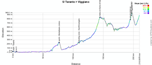
5/ Wednesday 13 May 2014 - Taranto > Viggiano - 203 km
After a transfer of about 90 kilometers, the 5th stage will be a bit longer with its 203 kilometers and also more hilly, especially in the second half of the stage.Indeed, after the start in Taranto, this stage will first follow a road which is parallel to the coast, down to Policoro, and just before they get there, the race route turns right land inwards towards the intermediate sprint of this stage in Montalbano Jonico followed by the climb of the Valico di Serra San Chirico and finally the uphill finish in Viggiano. A hill which the riders will climb two times: the first one until the top, followed by one lap on a circuit around the finish city, and a second time almost until the top, for the finish.
Hereunder you'll find the race route on Google Maps, the profile and the itinerary (including the time at which it comes through the different cities and villages on the race route) of this stage of the Tour of Italy 2014. Click on the images to open them:


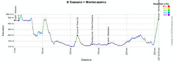
6/ Thursday 15 May 2014 - Sassano > Montecassino - 247 km
An even longer stage, of 247 kilometers, will take place on Thursday 15 May 2014, between Sassano and Montecassino. Only one difficulty is on the programme of this stage, in Cava de Tirreni, in addition to the uphill finish.The feeding zone will be just after this climb, in Palma Campania, and the sprint a bit further, in Maddaloni.
Hereunder you'll find the race route on Google Maps, the profile and the itinerary (including the time at which it comes through the different cities and villages on the race route) of this stage of the Tour of Italy 2014. Click on the images to open them:


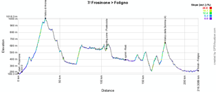
7/ Friday 16 May 2014 - Frosino > Foligno - 211 km
A big transfer of 184 kilometers will bring the peloton of the Tour of Italy 2014 towards Frosino this Friday 16 May, where the start of the 7th stage will be given, followed by a climb quite early in the stage, in Valico di Arcinazzo, and another one towards the end, in Valico della Somma, before the flat finish in Foligno. Between the two climbs we'll first find the feeding zone in Posticciola and the intermediate sprint in Rieti.Hereunder you'll find the race route on Google Maps, the profile and the itinerary (including the time at which it comes through the different cities and villages on the race route) of this stage of the Tour of Italy 2014. Click on the images to open them:


CONTINUE READING AFTER THIS ADVERTISEMENT
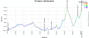
8/ Saturday 17 May 2014 - Foligno > Montecopiolo - 179 km
From Foligno, the peloton continues this Saturday it's way up north and after the feeding zone in Acqualagna and the intermediate sprint in Urbania a loop close to the finish will allow the riders to climb the Cippo di Carpegna (6 km @ 9.9% with a maximum of 14%) and towards Villagio del Lago (9.3 km @ 6.2% with a maximum of 11%) before the uphill finish in Montecopiolo (6.4 km @ 6.4% and a maximum of 13%).Hereunder you'll find the race route on Google Maps, the profile and the itinerary (including the time at which it comes through the different cities and villages on the race route) of this stage of the Tour of Italy 2014. Click on the images to open them:


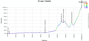
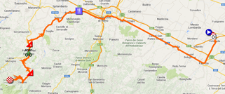
9/ Sunday 18 May 2014 - Lugo > Sestola - 172 km
The first 100 kilometers of the 9th stage after the start from Lugo are completely flat and almost in a straight line! After having crossed the feeding zone in Crespellano, the riders climb two hills in Sant'Antonio (followed by the intermediate sprint in Pavullo nel Frignano) and in Rocchetta Sandri before they go one with the longer final climb, towards Sestola (16.5 km @ 5.5% with a maximum of 13%).Hereunder you'll find the race route on Google Maps, the profile and the itinerary (including the time at which it comes through the different cities and villages on the race route) of this stage of the Tour of Italy 2014. Click on the images to open them:

R2/ Monday 19 May 2014 - rest day
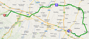
The second rest day of this Giro d'Italia 2014 will be a real rest day for the riders since the transfer towards the next day's race start is extremely short.10/ Tuesday 20 May 2014 - Modena > Salsomaggiore Terme - 173 km
After this second rest day, the caravan of the Giro will come back together in Modena for a flat stage, towards Salsomaggiore Terme. In this stage, the riders will find the intermediate sprint in Mirandola and the feeding zone in Villarotta before they go on from Parma to Fidenza and then probably towards a bunch sprint which will decide the victory of this stage.Hereunder you'll find the race route on Google Maps, the profile and the itinerary (including the time at which it comes through the different cities and villages on the race route) of this stage of the Tour of Italy 2014. Click on the images to open them:


CONTINUE READING AFTER THIS ADVERTISEMENT
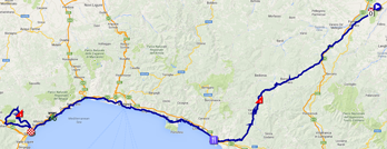
11/ Wednesday 21 May 2014 - Colecchio > Savona - 249 km
The 11th stage of the Giro d'Italia 2014 is again a very long stage, of 249 kilometers, between Colecchio and Savona. From Colecchio the riders will go towards the coast via the Passo Cento Croci and then follow the coast line via Genova down to Savona where they'll do a loop around the finish city, to go find the climb of Naso di Gatto.In the profile of this stage we can clearly see that this is the only middle mountain stage which doesn't have an uphill finish.
Hereunder you'll find the race route on Google Maps, the profile and the itinerary (including the time at which it comes through the different cities and villages on the race route) of this stage of the Tour of Italy 2014. Click on the images to open them:


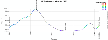
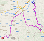
12/ Thursday 22 May 2014 - Barbaresco > Barolo - 41,9 km - individual time trial
The second time trial of this Giro d'Italia 2014, an individual one this time, will take place on Thursday 22 May 2014. Even though it was initially announced to be on a relatively flat track, we finally find a race route between Barbaresco and Barolo, about 42 kilometers further, with a nice climb to start with, towards the first intermediate timing point in Boscasso.Hereunder you'll find the race route on Google Maps, the profile and the itinerary (including the time at which it comes through the different cities and villages on the race route) of this stage of the Tour of Italy 2014. Click on the images to open them:

13/ Friday 23 May 2014 - Fossano > Rivarolo Canavese - 157 km
This will be a quite rolling stage, of 157 kilometers, starting in Fossano, with the only difficulty being the Salita di Rivara just before the riders get on the final circuit in which they'll find the intermediate sprint of Cuorgnè before the finish in Rivarolo Canavese.Hereunder you'll find the race route on Google Maps, the profile and the itinerary (including the time at which it comes through the different cities and villages on the race route) of this stage of the Tour of Italy 2014. Click on the images to open them:


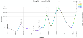
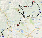
14/ Saturday 24 May 2014 - Agliè > Oropa (Biella) - 164 km
The 14th stage will be a mountain stage between Agliè and Oropa.After 30 kilometers, the riders get on the top of the first climb of this stage, in La Serra, followed by about fifty rolling kilometers with the intermediate sprint in Cossato and the feeding zone in Roasio before they get at the foot of the Alpe Noveis (9 km @ 7.9% and a maximum of 16%) which will be followed by the climb of Bielmonte (18.4 km @ 5.6% and a maximum of 13%) and after the descent of that climb, the final climb towards the finish at the Santuario di Oropa (11.8 km @ 6.2% and a maximum of 13%) will be awaiting the riders.
Hereunder you'll find the race route on Google Maps, the profile and the itinerary (including the time at which it comes through the different cities and villages on the race route) of this stage of the Tour of Italy 2014. Click on the images to open them:

CONTINUE READING AFTER THIS ADVERTISEMENT
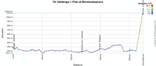
15/ Sunday 25 May 2014 - Valdengo > Plan di Montecampione - 225 km
The second day of this weekend there will be another mountain stage, with mountain top finish, but this time the approach of this final climb is completely flat over about 200 kilometers after the start from Valdengo!Indeed, only the final climb towards the Plan di Montecampione will be awaiting the riders that day. This will be a 19.4 km long climb @ 7.6% with a maximum of 12%.
Hereunder you'll find the race route on Google Maps, the profile and the itinerary (including the time at which it comes through the different cities and villages on the race route) of this stage of the Tour of Italy 2014. Click on the images to open them:


R3/ Monday 26 May 2014 - rest day
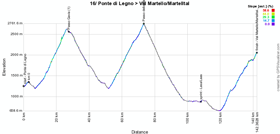
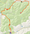
This weekend made up of two mountain stages will be followed by another rest day, the 3rd of this Giro.16/ Tuesday 27 May 2014 - Ponte di Legno > Val Martello (Martelltal) - 139 km
A real mountain stage will be awaiting the riders this Tuesday after this last rest day of the 97th Tour of Italy.Indeed, after the start from Ponte di Legno they'll have only about 5 kilometers slightly downhill before they start the first climb of the stage, the Passo Gavia (16.5 km @ 8% with a maximum of 16%) and it will be followed by the climb towards the rooftop of this Giro d'Italia 2014, the cima coppi, the Passo di Stelvio (21.7 km @ 7.1% with a maximum of 12%) and after a few kilometers in the valley, with the intermediate sprint in Lasa/Laas, the final climb towards Val Martello will be 22.4 km long @ 6.4% with a maximum of 14%.
Hereunder you'll find the race route on Google Maps, the profile and the itinerary (including the time at which it comes through the different cities and villages on the race route) of this stage of the Tour of Italy 2014. Click on the images to open them:

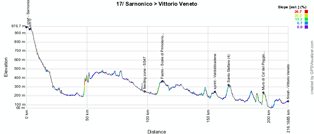
17/ Wednesday 28 May 2014 - Sarnonico > Vittorio Veneto - 208 km
The next day, the stage will be a bit easier, between Sarnonico and Vittorio Veneto with only 3 hills to climb, in Fastro-Scale di Primolano, in Santo Stefano and the Muro di Ca' del Poggio.Hereunder you'll find the race route on Google Maps, the profile and the itinerary (including the time at which it comes through the different cities and villages on the race route) of this stage of the Tour of Italy 2014. Click on the images to open them:

CONTINUE READING AFTER THIS ADVERTISEMENT
18/ Thursday 29 May 2014 - Belluno > Rifugio Panarotta (Valsugana) - 171 km
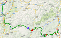
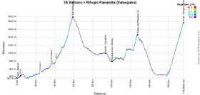
This Thursday there'll be another real mountain stage on the programme, starting in Belluno. Rapidly after the start the riders will get on the long climb of the first mountain (18.5 km @ 6.2%), the Passo San Pellegrino (1918 m). After a long trip through the vally, with the intermediate sprint in Cavalese and the feeding zone in Molina di Fiemme, a shorter but steeper climb will follow, the Passo del Redebus (4.6 km @ 8.7%). After this climb and its descent, about fifteen kilometers will bring the riders to the foot of the final climb, towards the Rifugio Panarotta in Valsugana. This climb is 15.9 km long @ 7.9% and a maximum of 14%.Hereunder you'll find the race route on Google Maps, the profile and the itinerary (including the time at which it comes through the different cities and villages on the race route) of this stage of the Tour of Italy 2014. Click on the images to open them:

19/ Friday 30 May 2014 - Bassano del Grappa > Cima Grappa - 26.8 km - individual time trial
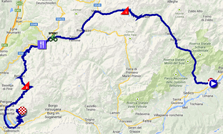
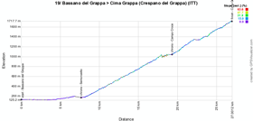
Another individual time trial will take place this last Friday of the Giro d'Italia 2014. This time it'll be the famous cronoscalata of the Giro d'Italia 2014, on a 19.3 kilometer long climb (after 7.5 kilometers flat) @ 8% and going up to 14%.Hereunder you'll find the race route on Google Maps, the profile and the itinerary (including the time at which it comes through the different cities and villages on the race route) of this stage of the Tour of Italy 2014. Click on the images to open them:


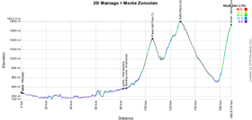
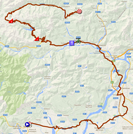
20/ Saturday 31 May 2014 - Maniago > Monte Zoncolan - 167 km
Starting in Maniago, the riders will first do 90 kilometers flat, with the intermediate sprint in Villa Santina and the feeding zone in Enemonzo. Just afterwards, the Passo del Pura (11.3 km @ 7.7% and a maximum of 13%) and the Sella Razzo (15.9 km @ 5.2% and a maximum of 15%) will actually only be a starter for the main dish, the final climb of the famous Monte Zoncolan (10.1 km @ 11.9% and a maximum of 22%).Hereunder you'll find the race route on Google Maps, the profile and the itinerary (including the time at which it comes through the different cities and villages on the race route) of this stage of the Tour of Italy 2014. Click on the images to open them:

21/ Sunday 1st of June 2014 - Gemona di Friuli > Trieste - 172 km
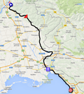
The last stage of the Giro d'Italia 2014 is pretty much a ceremonial one. It'll be a flat stage starting in Gemona di Friuli. The top of the last hill of this first Grand Tour of the year will be reached after only 21.7 kilometers, on the Passo di Monte Croce and the rest of the stage doesn't contain any further difficulties. Once they get in Trieste, the riders will do 8 laps of 7.2 kilometers before they finally finish this Giro d'Italia 2014 and before we get to know who'll take home the pink jersey after Vincenzo Nibali last year!Hereunder you'll find the race route on Google Maps, the profile and the itinerary (including the time at which it comes through the different cities and villages on the race route) of this stage of the Tour of Italy 2014. Click on the images to open them:


The Giro d'Italia 2014 race route in Google Earth
Do you prefer to see the race route of all stages of the Tour of Italy 2014 in one view? Or would you like to do a virtual fly-over over one or more of these stages? That's possible if you download the following KMZ file (a zipped KML file, due to its big file size) and open it in Google Earth. ATTENTION - copyright: despite the fact that this KMZ file is provided for your own use, you must note that it is strictly forbidden to reproduce the contents of this KMZ file or any other file (including the maps, the profiles, the KML files and others) which make up the Tour of Italy 2014 race route, in any form. These contents are indeed protected by a copyright (as any other contents published on velowire.com) and I'd like to ask you to show your respect for the huge amount of time I spent on the creation of these contents.
>> Download the complete race route of the Giro d'Italia 2014 in Google Earth (KMZ file, 764 kB)

Vond u dit artikel interessant? Laat het uw vrienden op Facebook weten door op de buttons hieronder te klikken!
1 comment | 49926 views
this publication is published in: Giro d Italia | Giro d'Italia 2014 | OpenStreetMap/Google Maps/Google Earth


 by marco1988 over
Avec le parcous qu'il y a et les coureurs au départ, ça va dynamiter.