Sunday 16 September 2012 at 11h37
Today the World Championships Cycling on the road 2012 start in Limburg in The Netherlands. In the region of the Amstel Gold Race there are no less than 7 race days (spread over 8 days) on the programme of the World Championships.
In this article you'll find the detailed race routes of all these races, in all categories, on Google Maps/Google Earth.
CONTINUE READING AFTER THIS ADVERTISEMENT
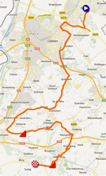
Team Time Trial UCI teams women - zondag 16 September 2012 - 11AM > 12.30PM - Sittard > Geleen - 34.2 km
It all started today with the time trial for UCI women's teams, a first for the modern World Championships. Indeed, it's the first time in the history of the World Championships that we'll see a team time trial for brand teams, knowing that the team time trial for national teams disappeared in 1994 when the individual time trial was introduced in the World Championships.For the women this will be a 34.2 kilometer long race on a hilly race route between Sittard and the finish in Valkenburg. In this race route they'll find two climbs, the Lange Raarberg, 1.3 km long and with an average slope of 4.5%, and the famous Cauberg, 1.2 km long @ 5.8%.
The race route of all time trials of these World Championships is quite technical with some tight turns at some places and that also goes for the women's team time trial!
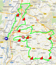
Hereunder you'll find the race route on Google Maps and the profile of this race. Click on the images to open them.

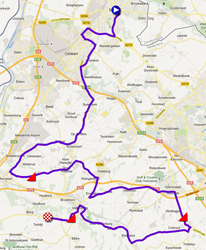
Team Time Trial UCI teams men - Sunday 16 September 2012 - 1.30PM > 4.40PM - Sittard > Geleen - 53.2 km
The race route of the men's teams is almost the same as the one for the women but has been made a bit longer because after the Lange Raarberg the men go off to Voerendaal and the Bergseweg (2.7 km long with an average slope of 3.3%) to come to a total of three climbs.Hereunder you'll find the race route on Google Maps and the profile of this race. Click on the images to open them.

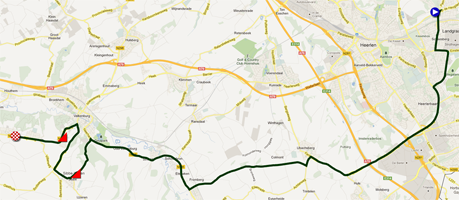
Individual time trial junior men - Monday 17 September 2012 - 10AM > 12.05PM - Landgraaf > Valkenburg - 26.6 km
The individual time trials will start tomorrow, first with the junior men. They will follow a 26.6 kilometer long route which starts in Landgraaf and which will have the usual finish in Valkenburg. In the last part of the race they'll climb Sibbergrubbe (2.1 kilometer @ 4.1%) and the Cauberg.Hereunder you'll find the race route on Google Maps and the profile of this race. Click on the images to open them.

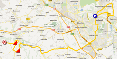
Individual time trial Under-23 men - Monday 17 September 2012 - 2PM > 4.25PM - Landgraaf > Valkenburg - 36 km
In the afternoon it's time for the men under 23 to get to the start ramp in Landgraaf. They will follow almost the same race route but this time it's almost 10 kilometers longer thanks to an additional loop around the start city. The rest of the race route towards the finish in Valkenburg is exactly the same, with the climbs of Sibbergrubbe and the Cauberg.Hereunder you'll find the race route on Google Maps and the profile of this race. Click on the images to open them.

CONTINUE READING AFTER THIS ADVERTISEMENT
Individual time trial junior women - Tuesday 18 September 2012 - 10.30AM > 12.20PM - Eijsden/Margraten > Valkenburg - 15.6 km
In order to allow as many cities in Limburg as possible to enjoy the World Championships the start of the different time trials takes place in different cities and for the women that'll be Eijsden. A short race route, 15.6 kilometers, turning around Maastricht towards Valkenburg, this time with only one climb, Bukel: 900 meters @ 4.1%.Hereunder you'll find the race route on Google Maps and the profile of this race. Click on the images to open them.

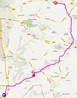
Individual time trial women elite - Tuesday 18 September 2012 - 2.30PM > 4.50PM - Eijsden/Margraten > Valkenburg - 24.3 km
In the afternoon the women elite will have the same start and finish but the race route is slightly different, in order to come to a distance of 24.3 kilometers: after the start from Eijsden the women directly go north and than east to get to the climb of the Gronsvelderberg, 2.1 kilometers long and with an average slope of 3.5%. Towards the end of the race route a detour in Valkenburg allows to climb the Cauberg in this race against the clock.Hereunder you'll find the race route on Google Maps and the profile of this race. Click on the images to open them.

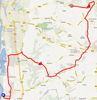
Individual time trial men elite - Wednesday 19 September 2012 - 1.30PM > 4.40PM - Heerlen > Valkenburg - 45.7 km
On Wednesday there will be only one race: the individual time trial for men elite which will take place in the afternoon on a 45.7 kilometer long race route. After the start from Heerlen the riders will climb the Sint Remigiusstraat after a bit more than 15 kilometers, a steep 1 kilometer long climb with an average slope of 7.7% and towards the end of the race route (after 40 km) the Rozekoel/Bundersberg, 800 meters long @ 5.4%, and the Cauberg.Hereunder you'll find the race route on Google Maps and the profile of this race. Click on the images to open them.

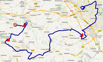
Road races
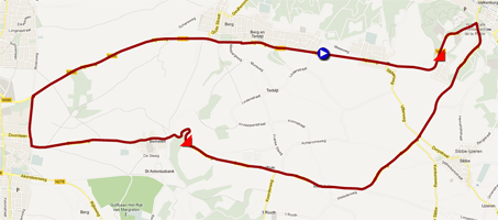
The race routes of the road races all use the 16.1 kilometer long circuit around Valkenburg with start and finish at the usual finish location for all time trial races.On this circuit, the riders first go towards Maastricht but they turn just before they enter the city and than reach the Bemelerberg (900 meters with an average slope of 5%). Going towards Sibbe they'll get back on the climb of the Cauberg which they should know by than!
This circuit will be used for the following races:
- Friday 21 September 2012 from 2PM till 4.10PM: junior women - 4 laps on the circuit - 65 km
- Saturday 22 September 2012 from 9PM till 1.15PM: U-23 men - 11 laps on the circuit - 177 km
- Saturday 22 September 2012 from 2.30PM till 5.45PM: women elite - 8 laps on the circuit - 129 km
- Sunday 23 September 2012 from 9AM till 12.10PM: junior men - 8 laps on the circuit - 129 km
and for the road race men elite of course, but since that races also uses a route to get on the circuit it is presented more in detail below ...
Hereunder you'll find the race route on Google Maps and the profile of this circuit. Click on the images to open them.

CONTINUE READING AFTER THIS ADVERTISEMENT
Road race men elite - Sunday 23 September 2012 - 10.45AM > 5PM - Maastricht > Valkenburg - 267 km
The race in line for the men elite will thus use the same circuit around Valkenburg, 10 times, but before that the riders will visit, from the start in Maastricht, almost the whole southern part of the province of Limburg mainly following the roads which are usually part of the Amstel Gold Race. The riders will thus climb the Maasberg (500m @ 4.4%), the Adsteeg (500m @ 5.4%), the Lange Raarberg (1.3 km @ 4.5%), the Daelseweg/Putberg (1.4 km @ 4.6%), the Rugweg (3.1 km @ 3.2%), Eperheide (2.3 km @ 4.5%), Hoogcruts / Piemert (1 km @ 5.8%) before they arrive on the circuit where they will cross the finish line for the first time after 106.4 km in the race.By adding 10 laps on the circuit as described above, with the Bemelerberg and the Cauberg, they will get to a total distance of 267.4 kilometers.
Hereunder you'll find the race route on Google Maps and the profile of this race. Click on the images to open them.

The race routes of the World Championships 2012 in Google Earth
Hereunder you can download a KML file which you can open in Google Earth to check out the race routes of all races with that application and thus for example do a virtual fly-over over these routes!
Vond u dit artikel interessant? Laat het uw vrienden op Facebook weten door op de buttons hieronder te klikken!
2 comments | 12727 views
this publication is published in: World Championships Limburg 2012 | OpenStreetMap/Google Maps/Google Earth


 by marco1988 over
J'ai peur d'une course bloquée par les équipes d'Espagne, de Belgique, d'Italie et des Pays-Bas et un sprint à 40 unités en haut du Cauberg.
Mon favori est Boasson Hagen car il semble que Sagan ne va pas tenir la distance.
Pour les Français, il faut clairement une course de mouvement dès l'entrée sur le circuit final et nos alliés vont être les Italiens (Nibali ?).
Dossard 139 et représentant du Japon : Shinichi FUKUSHIMA... ça ne s'invente pas !!!