This Saturday the Giro d'Italia 2012 will start ... in Denmark! Indeed, the Tour of Italy 2012 will not start in a city in the country of the boot but will have it's 3 first stages in Denmark before a transfer to Italy.
In this article you'll find all information about this 95th edition of the Giro d'Italia with detailed maps with the race route on Google Maps, the profiles of each of the stages and their time- and route schedules. Finally, you'll be able to download the race route in Google Earth and for example do a virtual fly-over of one or morestages!
The Tour of Italy 2012 race route on Google Maps
CONTINUE READING AFTER THIS ADVERTISEMENT
1/ Saturday 5 May 2012 - Herning > Herning - individual time trial - 8.7 km
The Giro d'Italia will start with an individual time trial this year (the team time trial will have to wait the first stage in Italy). The race route is rather technical, especially at the start, with a big number of turns in the streets of Herning in Denmark. Only in the last 3 kilometers the riders will get onto long straight lines in which the specialists of this discipline will be able to go full gas.Hereunder you'll find the time- and route schedule, the stage profile and the race route on Google Maps for this stage. Click on the images to open them.


2/ Sunday 6 May 2012 - Herning > Herning - flat - 206 km
The second stage of the Tour of Italy 2012 will also have Herning as start and finish city. This time that'll however be for a stage of 206 kilometers which will first go West to get to the sea coast in Søndervig. From there, the riders will go north, along the coast line, up to Lemvig where they'll find both the feeding zone and the first difficulty of the Giro d'Italia 2012, the Østerbjerg.Until Resenstad / Struer they'll continue eastwards before going down south-east to the finish in Herning, via Holstebro. At the first crossing of the finish line they'll still have 12.4 kilometers to do on a circuit in the city before we'll get to know the winner of the 2nd stage.
Hereunder you'll find the time- and route schedule, the stage profile and the race route on Google Maps for this stage. Click on the images to open them.


3/ Monday 7 May 2012 - Horsens > Horsens - flat - 190 km
The third stage will be the last one in Denmark. This stage will also start and finish in the same city, but this time that'll be Horsens, on the east coast of Denmark. It'll start with a loop on the south side of the city, via Juelsminde before going back to the start city and turn north-east towards Odder.From there, the riders will turn west until Brædstrup, via a sprint in Hovegård, the feeding zone in Kattstrup and the only climb of the day, the Ejer Bavnehøj (5.4 km for a 89 meters height difference and an average steepness of 1.6% / with a maximum at 7%).
They'll than go back to Horsens and a circuit of 14.3 kilometers on which they'll do 3 laps before they take the direction of the finish line on the seaside.
Hereunder you'll find the time- and route schedule, the stage profile and the race route on Google Maps for this stage. Click on the images to open them.


R1/ Tuesday 8 May 2012 - Verona
After the finish of the 3rd stage in Horsens, the riders and followers of the Giro d'Italia 2012 will travel to the city of Verona in Italy where they'll enjoy the first rest day to revitalise after the first three stages and the transfer by plane.CONTINUE READING AFTER THIS ADVERTISEMENT
4/ Wednesday 9 May 2012 - Verona > Verona - team time trial - 33.2 km
In Italy we'll continue with another stage which has start and finish in the same city, this time in Verona, east of Milan, for a team time trial. The race against the clock will be on the west side of the city with a loop which mostly uses the same routes on the way back as on the way out.Hereunder you'll find the time- and route schedule, the stage profile and the race route on Google Maps for this stage. Click on the images to open them.


5/ Thursday 10 May 2012 - Modena > Fano - flat - 199 km
The 5th stage will start about one hundred kilometers south of Verona, in Modena and will be almost completely in a straight line, until the finish in Fano.In-between those two cities the riders will be able to grab something to eat in Forli before they dispute the intermediate sprint of the stage in Misano Adriatico. At 35 kilometers from the finish they'll reach the top of Gabicce Monte (2 kilometers @ 4.8% with a maximum of 9%).
Hereunder you'll find the time- and route schedule, the stage profile and the race route on Google Maps for this stage. Click on the images to open them.


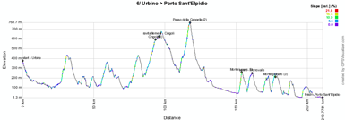
6/ Friday 11 May 2012 - Urbino > Porto Sant'Elpidio - medium mountain - 207 km
The medium mountains arrive in this Giro d'Italia 2012 in the 6th stage, with 4 difficulties.The start will be in Urbino for a stage going south-east towards the first difficulty of the day, in Cingoli (3rd category, 6.4 kilometers @ 6.5% with a maximum of 13%). They'll also find the feeding zone there. About twenty kilometers further, the riders will climb a 2nd mountain, the Passo della Cappella (4.5 kilometers @ 7.7% with a maximum of 16%) from where they'll go east to the sea side.
Before they get there and at the finish in Porto Sant'Elpidio they will however still have to climb two difficulties of the 3rd category: Montelupone (4.6 kilometers @ 4.4% with a maximum of 15%) and Montegranaro (1.2 kilometers @ 13.8% and a maximum of 18%).
Hereunder you'll find the time- and route schedule, the stage profile and the race route on Google Maps for this stage. Click on the images to open them.


7/ Saturday 12 May 2012 - Recanati > Rocca di Cambio - medium mountain - 205 km
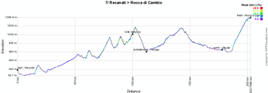
This 7th stage with a start in Recanati will progressively climb towards the Colle Gallucio (3rd category, 5.6 kilometers @ 5.4% with a maximum of 10%), followed by a non referenced climb to Piano Palasone.At the end of the descente, the intermediate sprint will be disputed on top of the short climb towards L'Aquila and from there the riders will start the final climb to the finish in Rocca di Cambio (2nd category, 19.1 kilometers @ 3.9% with a maximum of 10%).
Hereunder you'll find the time- and route schedule, the stage profile and the race route on Google Maps for this stage. Click on the images to open them.


CONTINUE READING AFTER THIS ADVERTISEMENT
8/ Sunday 13 May 2012 - Sulmona > Lago Laceno - medium mountain - 229 km
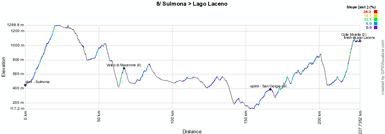
From Sulmona, the riders of the Giro d'Italia 2012 will go towards a 4th category climb, Valico di Macerone (3.6 kilometers @ 7.2% with a maximum of 10%). Halfway of the stage they'll get to the feeding zone and they'll continue, via Benevento, to the intermediate sprint in San Giorgio del Sannio.Before they arrive in Lago Laceno they'll climb the 2nd category Colle Molella (9.9 kilometers @ 5.9% with a maximum of 12%) of which the top will be reached at 4.4 kilometers from the finish.
Hereunder you'll find the time- and route schedule, the stage profile and the race route on Google Maps for this stage. Click on the images to open them.


9/ Monday 14 May 2012 - San Giorgio nel Sannio > Frosinone - flat - 171 km
From the 9th stage till the 13th stage the flat and medium mountain stages will alternate in the Tour of Italy 2012.This 9th stage will be from San Giorgio nel Sannio to Frosinone. The line of the intermediate sprint in this stage will be drawn in Ceprano.
Hereunder you'll find the time- and route schedule, the stage profile and the race route on Google Maps for this stage. Click on the images to open them.


10/ Tuesday 15 May 2012 - Civitavecchia > Assisi - medium mountain - 186 km
The 10th stage will be hilly between Civitavecchia and Assisi where the finish will be on top of a 4th category climb of 3.9 kilometers @ 8.8% (with a maximum of 15%). The intermediate sprint will be in Amelia.Hereunder you'll find the time- and route schedule, the stage profile and the race route on Google Maps for this stage. Click on the images to open them.


11/ Wednesday 16 May 2012 - Assisi > Montecatini Terme - flat - 255 km
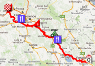
This 11th stage, qualified as flat by the organiser of the race, will contain 2 difficulties anyway. The start will be in the previous day's finish city, Assisi, from where the riders will go north-west via Perugia towards the feeding zone in Rigutino and than via Arezzo towards the intermediate sprint in Indicatore.About 50 kilometers further they'll climb the Poggio alla Croce (7.1 kilometers @ 5,3% with a maximum of 8%) before they get in a second feeding zone in Ginestra Fiorentina.
At the finish in Montecatini Terme they'll do one lap of a local circuit in which they'll find the climb of Vico (3.3 kilometers @ 5.2% with a maximum of 8%).
Hereunder you'll find the time- and route schedule, the stage profile and the race route on Google Maps for this stage. Click on the images to open them.


CONTINUE READING AFTER THIS ADVERTISEMENT
12/ Thursday 17 May 2012 - Seravezza > Sestri Levante - medium mountain - 155 km
Along the coast line, the riders will connect this Thursday 17 May the cities of Seravezza and Sestri Levante with each other. Going land-inwards from time to time they'll find 4 climbs: first La Foce (4th category, 3.6 kilometers @ 5.9% and a maximum of 9%), Valico Guaitaorla (3rd category, 9.8 kilometers @ 6.2% and a maximum of 10%) followed by the feeding zone in La Barraca and the intermediate sprint in Carro, and finally Valico la Mola (2nd category, 9.2 kilometers @ 5,2% and a maximum of 10%) and Villa Tassini (3rd category, 5 kilometers @ 5.9% and a maximum of 11%). The finish line will be drawn 11.2 kilometers further.Hereunder you'll find the time- and route schedule, the stage profile and the race route on Google Maps for this stage. Click on the images to open them.


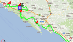
13/ Friday 18 May 2012 - Savona > Cervere - flat - 121 km
Between Savona and Cervere, the only climb on the programme of this stage will be in Montezemolo (4th category, 6.5 kilometers @ 4.7% and a maximum of 8%).The intermediate sprint will be in Carrù and there's no feeding zone in this stage.
Hereunder you'll find the time- and route schedule, the stage profile and the race route on Google Maps for this stage. Click on the images to open them.


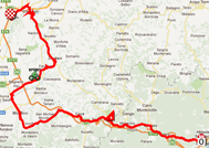
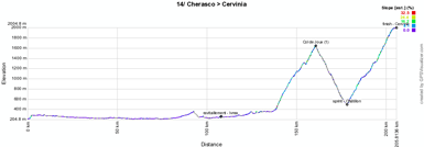
14/ Saturday 19 May 2012 - Cherasco > Cervinia - high mountain - 206 km
The 14th stage is the first high mountain stage. After the start from Cherasco, the riders will go up north via Turin and the feeding zone in Ivrea for a relatively calm start of the stage. The difficulties arrive after 137 kilometers with the climb of the Col de Joux (1st category, 22.4 kilometers @ 5.6% with a maximum of 12%) and after the descent of this mountain the stage goes on with the final climb towards Cervinia (also 1st category, 27 kilometers @ 5.5% and a maximum of 12%).Hereunder you'll find the time- and route schedule, the stage profile and the race route on Google Maps for this stage. Click on the images to open them.


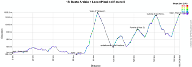
15/ Sunday 20 May 2012 - Busto Arsizio > Lecco/Piani dei Resinelli - high mountain - 169 km
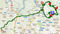
Another high mountain stage this Sunday, relatively calm until just after the intermediate sprint in Lecco. From there several climbs will follow: Valcio di Valcava (1st category, 11.6 kilometers @ 8.1% with a maximum of 17%), the non referenced climb of Berbenno, Forcella di Bura (3rd category, 10.9 kilometers @ 4.3% with a maximum of 12%), Culmine di San Pietro (2nd category, 9.8 kilometers @ 5.2% with a maximum of 12%) and the final climb, also 2nd category, towards Lecco - Piani dei Resinelli (7.8 kilometers @ 7.8% with a maximum of 12%).Hereunder you'll find the time- and route schedule, the stage profile and the race route on Google Maps for this stage. Click on the images to open them.

CONTINUE READING AFTER THIS ADVERTISEMENT
R2/ Monday 21 May 2012 - Limone sul Garda
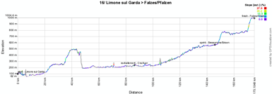
After no less than 12 stages non stop, including two high mountain stages the weekend before this Monday, the riders can finally get some rest during this second rest day.16/ Tuesday 22 May 2012 - Limone sul Garda > Falzes/Pfalzen - medium mountain - 173 km
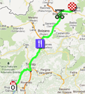
Between Limone sul Garda and Falzes/Pfalzen the stage will climb almost all the time and will end in a hill.The feeding zone will be in Ora/Auer while the intermediate sprint is in Bressanona/Brixen.
Hereunder you'll find the time- and route schedule, the stage profile and the race route on Google Maps for this stage. Click on the images to open them.

17/ Wednesday 23 May 2012 - Falzes/Pfalzen > Cortina d'Ampezzo - high mountain - 186 km
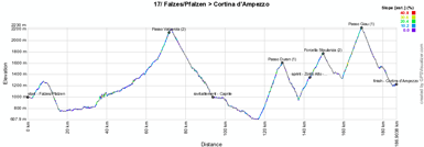
After a small bump right from the start in Falzes (Pfalzen) the difficulties in this 17th stage will start after 28 kilometers, with the climb of the Passo Valparola (2nd category, 14.1 kilometers @ 5.5% and a maximum of 13%). In the descent we'll find the feeding zone in Caprile, followed by the Passo Duran (1st category, 12.2 kilometers @ 8.1% with a maximum of 14%), Forcella Staulanza (2nd category, 12.3 kilometers @ 6.9% and a maximum of 11%) and the Passo Giau (1st category, 9.9 kilometers @ 9.3% and a maximum of 14%). At the end of the descent of the last one the riders will cross the finish line in Cortina d'Ampezzo.Hereunder you'll find the time- and route schedule, the stage profile and the race route on Google Maps for this stage. Click on the images to open them.


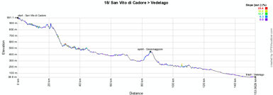
18/ Thursday 24 May 2012 - San Vito di Cadore > Vedelago - flat - 149 km
This 18th stage du Giro d'Italia 2012 is a short and flat stage which connects San Vito di Cadore with Vedelago via Belluno and the intermediate sprint in Cesiomaggiore.Hereunder you'll find the time- and route schedule, the stage profile and the race route on Google Maps for this stage. Click on the images to open them.


CONTINUE READING AFTER THIS ADVERTISEMENT
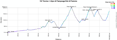
19/ Friday 25 May 2012 - Treviso > Alpe di Pampeago/Val di Fiemme - high mountain - 198 km
Two high mountain stages will end the Tour of Italy 2012 before the usual individual time trial.First of all on Friday 25 with a stage which will start in Treviso and climb progressively to the Sella di Roa (3rd category, 7 kilometers @ 6.6% with a maximum of 11%) followed by a short hill in Bieno. After the descent the riders can grab some food in Castelnuovo before they start the climb of the first 1st category hill out of three: Passo Manghen (20.5 kilometers @ 7.4% and a maximum of 15%). This will followed by the intermediate sprint in Tesero and the 3 last mountains: just after a first crossing of the finish line they'll get on the top of the Passo Pampeago Reiterjoch (1st category, 10.5 kilometers @ 9.7% with a maximum of 16%), on the way back of the final loop the Passo Lavazè (2nd category, 6.3 kilometers @ 8.6% and a maximum of 13%) and again the climb towards Passo Pampeago which will this time end at Alpe di Pampeago/Val di Fiemme (1st category, 7.7 kilometers @ 9.8%).
Hereunder you'll find the time- and route schedule, the stage profile and the race route on Google Maps for this stage. Click on the images to open them.

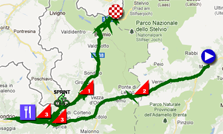
20/ Saturday 26 May 2012 - Caldes/Val di Sole > Passo dello Stelvio - high mountain - 219 km
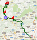
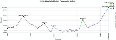
The last stage in line is also a high mountain stage. After the start from Caldes/Val di Sole the riders will immediately start the climb towards the Passo del Tonale (2nd category, 15.1 kilometers @ 6.1%) of which the top will be reach after a bit less than 33 kilometers. The descente of this mountain will immediately go on into the climb of Aprica (3rd category, 15.9 kilometers @ 3.1% with a maximum of 9%) which will go on into the climb towards Teglio (3rd category, 5.9 kilometers @ 8% and a maximum of 15%).On the part which is a little bit less hilly we'll find the feeding zone in Chiuro and the intermediate sprint in Tirano. The two 1st category mountains will end off this stage: first the famous Mortirolo (1st category, 11.4 kilometers @ 10.5% and a maximum of no less than 22%) and after the descent a progressive climb which intensifies from Bagni di Bormio to get on the top of the Passo dello Stelvio (1st category, 22.4 kilometers @ 6.9% with a maximum of 12%) which forms with its 2757 meters altitude the rooftop of this Tour of Italy.
Hereunder you'll find the time- and route schedule, the stage profile and the race route on Google Maps for this stage. Click on the images to open them.

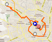
21/ Sunday 27 May 2012 - Milano > Milano - individual time trial - 30.1 km
The last stage is the usual individual time trial. Like last year it will take place in the streets of Milan but the race route is a little bit different. Start and finish will be at the same place as last year however, respectively on the Piazza Castello and the Piazza Duomo.Hereunder you'll find the time- and route schedule, the stage profile and the race route on Google Maps for this stage. Click on the images to open them.


The Giro d'Italia 2012 map in Google Earth
Would you like to see all stages of the Tour of Italy 2012 on a single map? Or do you want to discover all details of these 21 stages by doing a virtual fly-over of the race route? Download the KML file below and open it in Google Earth:>> Download the Giro d'Italia 2012 race route in Google Earth

Some of these maps have been created in collaboration with TeamSkyFans.com and CyclingTheAlps.com. Any mistakes in these maps have been corrected in the versions you'll find above. door Thomas Vergouwen
Vond u dit artikel interessant? Laat het uw vrienden op Facebook weten door op de buttons hieronder te klikken!
8 comments | 33889 views
this publication is published in: Giro d Italia | Giro d'Italia 2012 | OpenStreetMap/Google Maps/Google Earth


 by marco1988 over
http://www.les-actus-du-cyclisme.fr/article-le-parcours-du-giro-d-italia-2012-sur-google-maps-google-earth-les-profils-et-les-itineraires-horai-104507982.html
Avec seulement 4 étapes de haute montagne, le Giro 2012 sera beaucoup moins
difficile qu'en 2011...
Les 5 étapes de haute montagne de la dernière semaine sont superbement dessinées. Ca va faire un spectacle de fou!
Une nouvelle affaire Rabobank?
A quelques heures du départ du Giro, la Rabobank se
retrouve au coeur d'une nouvelle affaire de dopage...
INFO équipe.fr
@HONORé : ce n'est ni une info et encore moins de source équipe.fr. C'est simplement un journaliste du journal néerlandais Volkskrant qui a ressorti de vieux trucs qui datent d'il y a quelques mois. Zéro nouvelles et rien de concret donc. C'est ce qu'on appelle du journalisme de sensation surtout quand on voit à quel moment ça (re)sort !
Et comme les journalistes (si on doit encore les appeler comme ça) n'ont plus envie de nos jours de faire de vraies investigations, L'Equipe fait un simple copier/coller (+ traduction) du contenu de l'article du Volkskrant sans aucune analyse ou autre commentaire. C'est ce qu'on appelle le niveau d'un site français qui porte les initiales C'A ;-).
Effectivement, l'Équipe reprend un papier du Volkskrant...
Thomas,
Je ne comprends pas votre dernière phrase...?
@Dom : quand quelqu'un s'appelle journaliste et ne fait rien d'autre que des copier/coller, ça me fait étrangement penser à un site français qui pratique la même chose et utilise malgré cela des formulations du type "Tyler Farrar nous confie ..." ou encore "Fränk Schleck nous disait ...".