Sunday 13 February 2011 at 23h35
Now the Tour Méditerranéen is over, it's time to get ready for the 2011 Tour du Haut Var. This race, which is composed of 2 stages since 2009, will take place next weekend, on Saturday 19 and Sunday 20 February 2011.
Who will succeed to Christophe Le Mével in this race filled with climbs?
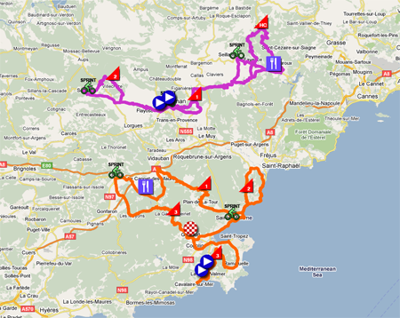
As you'll see with the 2011 Tour du Haut Var race route on Google Maps, this race is once again made for a pure climber!
Short summary of the Tour Med
The Tour Med has been a celebration for French riders this year. Indeed, after a first stage victory by Thomas Voeckler (Team Europcar) staying ahead with a leading group, Romain Feillu signed for no less than stage victories which finished in a sprint, thus getting the lead in the general classification right from the third stage. In the last stage, the Mont Faron played its usual decisive role in the Tour Méditerranéen and this again led to a triple victory. Not in the same year but as the 3rd stage victory on top of the Mont Faron for David Moncoutié (Cofidis, le crédit en ligne). The climbing expert caught up with Jean-Christophe Péraud (AG2R La Mondiale) and Steve Cummings (Team Sky) in the final climb and while the first mentioned finished 11 seconds later on the top, the English rider dropped back down. Behind Péraud, the Dutch rider Wout Poels (Vacansoleil-DCM Pro Cycling Team) finished 3rd.The top 5 of the general classification, completed by Andrew Talansky (Team Garmin-Cervélo) and Morris Possoni (Team Sky), was finally the same as the top 5 of the last stage.
The 2011 Tour du Haut Var race route on Google Maps
The 2011 Tour du Haut Var is composed, as usual since 2009, of 2 stages. The first stage runs from La Croix Valmer to Grimaud over 168.8 km while the second stage starts and finishes in Draguignan for a distance of 207 km.Officially the race is simply called Tour du Haut Var, but apparently the sponsoring links with the local newspaper Var Matin are that strong that on the official website of the race it's called Tour du Haut Var Matin ...
CONTINUE READING AFTER THIS ADVERTISEMENT
1/ Saturday 19 February 2011 - La Croix Valmer > Grimaud - 168.8 km
The first stage starts with a short loop from La Croix Valmer to Cavalaire-sur-Mer before the official start on the way back to La Croix Valmer, at the Elf gas station.After the start, the riders rapidly go towards the first climb of this Tour du Haut Var 2011, the Col de Gassin where the riders will arrive on top after 9.3 kilometers. After a quick descent, they continue down to Ramatuelle before getting back up towards Saint-Tropez.
They'll than continue, via Cogolin, towards the finish line in Grimaud where they'll dispute the first sprint of this Tour du Haut Var 2011. The climb landside continues with the Col de la Garde-Freinet and the second sprint in Le Luc in front of the Les Meubles du Luc shop.
Continuing east, they'll get into the feeding zone while crossing the river Aille. A bit further, they'll climb the Col du Revest before going back seaside towards Sainte-Maxime via Plan-de-la-Tour. From Sainte-Maxime they'll follow a loop following the coast line up to Saint-Aygulf and get back to Sainte-Maxime by climbing the Col du Bougnon.
After a final sprint in front of the Casino Barrière in Sainte-Maxime, they'll once again follow the coast line to get back to Grimaud where they climb to the finish line in front of the Hôtel de Ville.
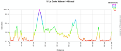
Below you can find the profile and the map with the race route of the first stage of the Tour du Haut Var 2011.


2/ Sunday 20 February 2011 - Draguignan > Draguignan - 207 km
The second stage which, according to Var Matin, should have started in Fayence, but will finally both start and finish in Draguignan in honour of the victims of the floods on 15 June in the Var.After the start from Draguignan, the riders go west towards a loop around Salernes where they'll climb the Côte de Tourtour. In Salernes they'll dispute the first intermediate sprint of this stage in front of Les Caves du Commandeur.
Via Fayosc they go back to Draguignan to attack the first climb of the Côte des Tuillières which they'll find once more at a decisive moment at the end of the stage. Before they reach the most eastwards point of this stage, the riders will get in the feed zone before turning towards Montauroux and the climb of its mur (wall) which contains a 300 meter portion at 22%!
After this non referenced climb, they'll continue straight through on the climb towards the top of the Col de Mons which is the highest point of the Tour du Haut Var 2011. A very winding descent will bring the riders back to Fayence for a new climb of the Côte de Montauroux.
Cutting short via Callian, they'll get back to Fayence to climb a 200 meter long wall at 25% before going towards Seillans for another sprint. After having passed Draguignan again and the finish line for the first time, they'll climb the Côte des Tuillières for the second time, at 23 kilometers from the finish.
The best climbers who would be leading on the top of this climb will have to give everything they can in the last 20 kilometers which are mostly downhill towards the finish line in the Boulevard Clémenceau in Draguignan.
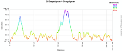
Below you can find the profile and the map with the race route of the second stage of the Tour du Haut Var 2011.


The Tour du Haut Var 2011 race route in Google Earth
If you'd like to see the race route of the two stages of the Tour du Haut Var 2011 in Google Earth, you can (after having installed Google Earth if necessary) click on the link below:>> Download the Tour du Haut Var 2011 race route in Google Earth

Vond u dit artikel interessant? Laat het uw vrienden op Facebook weten door op de buttons hieronder te klikken!
6 comments | 17882 views
this publication is published in: Tour du Haut Var | OpenStreetMap/Google Maps/Google Earth


 by marco1988 over
je suis fan de velo je regarde cette course tous les ans .a la tele surment pas cette annee mais je vais vous suivre sur internet beaucoup de belle bosses un français serait le bien venu comme au tour med bonne course a tour merci1
Merci pour votre superbe carte, Grace à celle-ci j'ai raté la course, ca aurait été bien si le parcours que vous avez détaillé sur le plan était le bon.
en effet je me suis rendu sur l'avenue de l'ancienne route de grasse au lieu de me rendre sur la vielle route de grasse!!
Merci
@vingere : mes cartes sur Google Maps sont établies sur base des informations fournies par l'organisateur de la course. Comme vous pouvez le constater vous-même sur le site officiel, les cartes fournies par l'organisateur sont illisibles. Je fais donc de mon mieux et au lieu de m'attaquer, je vous invite donc plutôt ... à attaquer l'organisateur de la course.
Toujours est-il que quand on se rend sur une course, on se renseigne aussi sur place. Cela m'étonnerait que vous n'ayiez pas eu l'impression d'être seul à attendre le passage de la course ... et que la route n'était pas fermée.
Désolé pour vous !
JE VOUDRAIS SAVOIR LE DEPART EXACTE DE FREYUS MERCI
Fréjus :
Départ fictif : Place de la Porte d’Hermès
Défilé : Rue Roger Louis, rond point à droite Avenue Paul Arène, RP tout droit rue William Shakespeare, RP à gauche Avenue de Provence [D559], RP à droite boulevard Séverin-Decuers [D98B], RP à droite rue des moulins et rue aristide briand, RP à gauche rue du docteur Robert Turcan, RP à gauche rue jean jaurès, à droite rue du général de gaulle, RP à droite Rue Henri Vadon, RP à droite avenue de Verdun, RP à droite [D4], RP tout droit [D4] et RP tout droit rue des combatants d'afrique du nord [D4].
Départ réel : rond-point des Combattants après 6,1 km de défilé.
Bonjour,
Pour voir le parcours précis des deux étapes du Tour du Haut Var 2012, je vous invite à vous rendre sur l'article correspondant dans la rubrique Tour du Haut Var : Le parcours du Tour du Haut Var 2012 sur Google Maps/Google Earth et les itinéraires horaires + profils.