initially published on 28 March 2012 at 12.10PM, updated on 15 August 2012 with some modifications based on local constraints
The race route of the Tour Poitou-Charentes 2012 and all other details have been presented only this morning and velowire.com already offers you the opportunity to find it on Google Maps/Google Earth!All details of this race which celebrates with its 26th edition its 25th anniversary can be found in this article: time- and route schedules, maps with the race route and stage profiles for each of the 5 stages which form this Tour Poitou-Charentes 2012.
New in the Google Maps race routes is that these have been illustrated with some photos of the stage start and finish cities! If you'd like to see them (please note that except for the stage starts on Thursday, these photos do not represent the exact start and finish locations), you can click on the icons for the stage start (départ fictif, white arrow on a blue circle) and finish (white/red checkerboard).
The Tour Poitou-Charentes 2012 race route on Google Maps
5 stages form the 26th edition of the Tour Poitou-Charentes from Tuesday 21 till Friday 24 August 2012: one stage in line on Tuesday, Wednesday and Friday and one stage in line plus an individual time trial on Thursday. Together, these stages offer a total distance of 691.5 kilometers.CONTINUE READING AFTER THIS ADVERTISEMENT
1/ Tuesday 21 August 2012 - Villebois-Lavalette > Royan - 182 km
After a stage start from the Place du Champ de Foire in the beautiful small city of Villebois-Lavalette, the riders will first do a 50 kilometer loop, first going south-west and than north-east via the first climb of this stage: a 5% hill over one sur un kilometer just before Rougnac.Once they visited Villebois-Lavalette for a second time, the riders continue with an intermediate sprint close to Fouquebrune before climbing another hill: 6% over 1,5 kilometers this time. They'll than continue with a sprint and feeding zone in Barbezieux and follow the road down to the seaside, or more precisely towards the Gironde where they'll battle for another intermediate sprint in Saint-Fort-sur-Gironde followed by a double climb of a 6% hill over one kilometer and the Côte de Tire cul which goes straight up with 15% over 400 meter.
From there they'll go straight through to the finish in Royan, on the Place du Maréchal Foch.
Hereunder you'll find the time- and route schedule, the profile and the race route on Google Maps for this stage. Click on each of the images to open them.


2/ Wednesday 22 August 2012 - Royan > Melle - 199.2 km
The longest stage of the Tour Poitou-Charentes 2012 will start in the coastal city where it finished the day before, from the Route du Front de Mer. After the start from the harbour of Royan, direction north-east, first of all to get to the first intermediate sprint in Plassay. Halfway of the stage, the riders will find the feeding zone in Saint-Pierre-de-Juilliers, a bit later followed by the second intermediate sprint of this stage, in Loiré-sur-Nie.Close to the finish, the riders will climb two hills, 4% over 700 meters and than 5% over 1.2 kilometers. In Lezay they'll battle for the 3rd and final intermediate sprint and than continue to the finish line in Melle. A final local circuit awaits them before they cross the finish line for the stage win on the Place René Groussard!
Hereunder you'll find the time- and route schedule, the profile and the race route on Google Maps for this stage. Click on each of the images to open them.


3/ Thursday 23 August 2012 - morning - Pleumartin > La Roche Posay - 99.4 km
On Thursday morning, a short stage will be waiting for the riders, between the Place de l'Hôtel de Ville in Pleumartin and the Rue de la Baignade in La Roche Posay. Between these two cities a quite original race route will allow the riders to get to a total distance of 99.4 kilometers in this stage.First of all they'll go south-west and than towards Chenevelles where they'll climb a 5% hill over 800 meters. They'll than continue north-east to get via the most northern point of this stage, Mairé, to the finish city: La Roche Posay. They'll continue with a second loop south of the thermal station via an intermediate sprint just before Vicq-sur-Gartempe and the climb of a 6% hill over 800 meter in Angles-sur-l'Anglin. They'll continue to the start city from where they'll go straight through to La Roche Posay again.
With this stage, the whole Communauté de communes des Vals de Gartempe et Creuse will thus be visited!
Hereunder you'll find the time- and route schedule, the profile and the race route on Google Maps for this stage. Click on each of the images to open them.


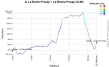
4/ Thursday 23 August 2012 - afternoon - time trial La Roche Posay > La Roche Posay - 22.1 km
If the morning stage is short that's of course done on purpose in order to allow the usual individual time trial to take place in the afternoon. This afternoon the start ramp will be installed in front of the Casino of La Roche Posay, one of the sponsors of the Tour Poitou-Charentes, for a solo ride of 22.1 kilometers which will finish at the same finish line as the morning stage. The race route forms a triangle between the thermal station, Vicq-sur-Gartempe and Pleumartin.Hereunder you'll find the time- and route schedule, the profile and the race route on Google Maps for this stage. Click on each of the images to open them.


CONTINUE READING AFTER THIS ADVERTISEMENT
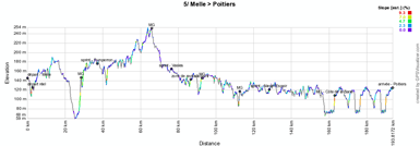
5/ Friday 24 August 2012 - Melle > Poitiers - 188.8 km
Friday's stage will go back to the finish city of the second stage, Melle, where it will start in front of the Complexe Sportif "Le Pinier". The finish will be as usual in the Rue de Nimègue in Poitiers.In Melle, the riders will go northwards to Saint-Maxent-l'Ecole and the climb of a 8% hill over 800 meters which ends in front of the church in Exireuil. At the entrance of Fomperron they'll battle for the first intermediate sprint of this stage, before the climb of the second difficulty of the stage which is 5% up over 1.2 kilometers.
Going east, they'll find an intermediate sprint in Vasles and the feeding zone a bit further. When they turn south-east they'll climb another 5% hill over 1.3 kilometers and close to Vivonne another one, at 6% over 600 meters.
Via the sprint in Nieuil l'Espoir they'll go back north to the final destination, Poitiers. After having crossed the city where Poitou-Charentes Animation is based, in Chasseneuil-du-Poitou, they'll do 3 laps on the local circuit which includes the steep climb of the Côte de la Barre (500 meters @ 11%).
At the end of this stage we'll know who will succeed Jesse Sergent as the winner of the Tour Poitou-Charentes!
Hereunder you'll find the time- and route schedule, the profile and the race route on Google Maps for this stage. Click on each of the images to open them.


The Tour Poitou-Charentes 2012 race route in Google Earth
Would you like to see all stages of the Tour Poitou-Charentes 2012 on one single map? Or would you like to go discover the 5 stages by doing a virtual fly-over of the race route? Than please download the KML file below and open it in Google Earth:>> Download the Tour Poitou-Charentes 2012 race route in Google Earth

The video of the Tour Poitou-Charentes 2012 race route
The organisor of the Tour Poitou-Charentes prepared quite an original video for its 2012 edition in which we not only see the race route of the different stages but also some photos of the cities which will receive this cycling race (of which quite many were taken by me in November last year ;-)):The teams which will be at the start of the Tour Poitou-Charentes 2012
On the 21st of August, 19 teams will come to the start of the race in Villebois-Lavalette.First of all there will be no less than 7 out of 18 UCI ProTeams with AG2R La Mondiale, Euskaltel-Euskadi, FDJ BigMat, GreenEDGE Cycling Team, Movistar Team, Radioshack-Nissan and Team Saxo Bank.
There will also be 6 Continental Pro teams of which 4 are French: Bretagne-Schuller, Cofidis, le crédit en ligne, Team Europcar and Saur-Sojasun plus the Belgian team Landbouwkrediet and the American Team Type 1-Sanofi.
Finally, 6 Continental teams complete the peloton at the start of the Tour Poitou-Charentes 2012:
- 4 French teams: Auber 93, Team La Pomme Marseille, Roubaix-Lille Métropole and Véranda Rideau-Super U
- 2 foreign teams: Rabobank Continental Team (The Netherlands) and Wallonie Bruxelles-Crédit Agricole (Belgium) door Thomas Vergouwen
Vond u dit artikel interessant? Laat het uw vrienden op Facebook weten door op de buttons hieronder te klikken!
2 comments | 15792 views
this publication is published in: Tour Poitou-Charentes | OpenStreetMap/Google Maps/Google Earth


 by Bernard over
  by Stuart over
  by Kiera over
http://www.les-actus-du-cyclisme.fr/article-tour-poitou-charentes-2012-son-parcours-sur-google-maps-google-102424070.html
https://cialiswithdapoxetine.com/ cialis alternative